Malá Fatra National Park
| Malá Fatra National Park Národný park Malá Fatra | |
|---|---|
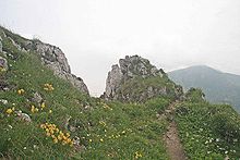
 Veľký Rozsutec (1,610 m) | |
| Location | West Slovakia |
| Coordinates | 49°12′50″N 19°04′51″E / 49.213969°N 19.080785°ECoordinates: 49°12′50″N 19°04′51″E / 49.213969°N 19.080785°E |
| Area | 226.3 km2 (87.37 mi2) |
| Established | 1 April 1988 |
| Governing body | Správa Národného parku Malá Fatra (Malá Fatra National Park administration) |

The Malá Fatra National Park (Slovak: Národný park Malá Fatra) is a national park in the northern part of the Malá Fatra mountains called Krivánska Malá Fatra.
It has an area of 226.3 km2 (87.37 mi2) and a 232.62 km2 (89.81 mi2) buffer zone. The park was declared in 1988. Between 1967 and 1988 it was a protected landscape area.
For a geological and geographical description see Malá Fatra.
Flora[]
The mountain is covered mainly with mixed beech forests, at higher elevations with fir and spruce. Pine woods and meadows occur at higher altitudes. About 83% of the area is covered in forest.
In the variety and beauty of flora species, the following examples stand out as the most remarkable:
- gentian (Gentiana clusii)
- auricula (Primula auricula)
- Dianthus nitidus
- round-leaved sundew (Drosera rotundifolia)
- lady's slipper orchid (Cypripedium calceolus)
The summit of Malý Kriváň (1,671 m) in the foreground

Šútovo Waterfall
Fauna[]
The fauna includes:
- golden eagle (Aquila chrysaetos)
- eagle-owl (Bubo bubo)
- black stork (Ciconia nigra)
- brown bear (Ursus arctos)
- lynx (Lynx lynx)
- beech marten (Martes foina)
- European otter (Lutra lutra)
- wildcat (Felis silvestris)
- grey wolf (Canis lupus)
Remarkable places[]
- (Crystal Cave) with calcite decoration, located in the Mountain
- the 38 metres high
- castles, such as the Strečno Castle and
- traditional architecture: Štefanová and Podšíp settlements
- Slovak folklore centres, such as the village of Terchová
- Jánošíkove diery (trans: Janosik holes) - system of gorges and canyons
See also[]
| Wikimedia Commons has media related to Národný park Malá Fatra. |
External links[]
| show Authority control |
|---|
Categories:
- IUCN Category II
- National parks of Slovakia
- Protected areas established in 1988
- Protected areas of the Western Carpathians
- Tourist attractions in Žilina Region
- Geography of Žilina Region