Malacca River
Coordinates: 2°12′N 102°15′E / 2.200°N 102.250°E

| Malacca River | |
|---|---|
 | |
| Native name | Sungai Melaka (Malay) |
| Physical characteristics | |
| Source | Tampin River |
| • location | Tampin, Negeri Sembilan |
| 2nd source | Batang Melaka River |
| • location | Batang Melaka |
| Mouth | Strait of Malacca |
• location | Malacca City |
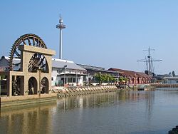
Malacca River (Malay: Sungai Melaka) which flows through the middle of Malacca City in Malacca, Malaysia, was a vital trade route during the heyday of Malacca Sultanate in the 15th century.
The river starts from the foothills in the neighbouring state of Negeri Sembilan and feeds into the Strait of Malacca. A USD$100 million (RM350 million) infrastructure project to revive and rejuvenate the river which is the central to Malacca as a historical city was carried out. This has included construction of a tidal barrage, restoration of buildings and bridges, dredging, concrete river banks with river walkways.[1] Land reclamation projects have extended the river mouth further into the Straits.[2]

Tourist attractions[]
See also[]
References[]
- ^ "Policy Responses to Attain the Water Quality Target: Malaysia Experience" (PDF). Retrieved 23 June 2016.
- ^ De Witt, Dennis (2010). Malacca from the Top. Malaysia: Nutmeg Publishing. p. 39. ISBN 9789834351922.
- ^ "Melaka River Cruise website".
- ^ "Melaka River Cruise".
| Wikimedia Commons has media related to Melaka River. |
This Malacca location article is a stub. You can help Wikipedia by . |
- Rivers of Malacca
- Tourist attractions in Malacca
- Rivers of Malaysia
- Malacca geography stubs
- Malaysia river stubs