Malaysian Federal Roads System
| Malaysian Federal Roads System (Sistem Jalan Persekutuan Malaysia) | |
|---|---|
 Highway shield of the Malaysian Federal Roads | |
| System information | |
| Maintained by Federal Public Works Department (JKR); numbers and routings assigned by Malaysian Ministry of Works.[1] | |
| Formed | 1957 (Peninsular Malaysia) 1986 (Sabah and Sarawak)[2] |
| Highway names | |
| Federal Roads | Federal Route nn (FT nn) |
| System links | |


Malaysian Federal Roads System (Malay: Sistem Jalan Persekutuan Malaysia), is the main national road network in Malaysia. All Federal Roads in Malaysia are under the purview of the Ministry of Works (MOW). According to the Ministerial Functions Act 1969, the MOW is responsible to plan, build and maintain all Federal Roads gazetted under the Federal Roads Act 1959.[3] However, most of the Federal roads' projects were built and maintained by the Malaysian Public Works Department (JKR), which is also one of the implementing agencies under the MOW (with the exception of Sabah and Sarawak, whereby JKR in these two states is under respective state government).
History[]
Most of the federal roads in Peninsular Malaysia were built during the British colonial era before 1957. At that time, the British government built the roads in order to enable them to transport goods and commodities easier.
In Sabah, most of the federal roads were built during the occupation of British North Borneo under North Borneo Chartered Company administration, and unlike most federal roads in Peninsular Malaysia which uses only numbers to label federal roads, Sabah federal road codes begin with the letter A followed by route number.
However, in Sarawak, no road network system was developed during the rule of White Rajah Brooke dynasty. As a result, right after Sarawak joined the federation of Malaysia on 16 September 1963, the federal government of Malaysia began to build a road network system connecting Sarawak to Sabah, known as Pan Borneo Highway.
Federal road standards[]
Overview[]
The total length of federal roads is 19,809 km (12,309 mi).[citation needed] (Grand Total for federal/state roads is 250,023km as of December 2019)
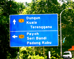
Federal routes are labeled with only numbers, for example Federal Route 1, while state routes are labeled with the state code letter followed by assigned numbers; for example Route (J)32 is a Johor state road. However, federal route numbers can also be added with the FT- prefix, which is normally used by JKR and Malaysian police. For example, Federal Route 1 can also be written as Federal Route FT1. Both federal and state roads have blue road signs and the text colour is white.
Most of the federal roads in Malaysia are two-lane roads. Malaysia implements a right-hand driving system where drivers drive on the left side of the road. However, there are in certain places where additional lanes are available. In town areas, federal roads may become four-lane roads to increase traffic capacity. In hilly areas, additional third climbing lane is available for slower vehicles such as buses and lorries.
Some federal roads may have motorcycle lanes. On Malaysian federal roads, the motorcycle lanes are placed at the extreme left side of each direction and only separated from the main lanes by black-and-white stripes to enable motorcyclists to overtake slower motorcycles and to turn right to exit the road.
Some expressways in Malaysia such as Federal Highway and Skudai Highway are federally funded, therefore all federally funded expressways are also classified as federal roads.
Nearly all federal roads are paved with typical tarmac except Skudai-Pontian Highway which is paved with concrete from Universiti Teknologi Malaysia interchange to Taman Sri Pulai junction and Sitiawan–Batak Rabit road (Federal route 5) from Sitiawan to Kota Setia. Meanwhile, at Federal Highway linking Klang to Kuala Lumpur, the section of the highway from Subang Jaya to Kota Darul Ehsan near Petaling Jaya are paved with asphalt.
Sarawak has some of the most extensive federal road network in Malaysia. All federal roads in Sarawak is connecting main divisions with exception of Mukah division. As for Kapit division, the only federal road serving this division is Jalan Bakun (starting from KM 95–KM 120). Coastal road of Bintulu–Miri is a still in dispute between federal government and state government right of maintenance. It is due to the construction is federal funded, but the compensation and acquisition of land are from Sarawak state government. No federal roads are isolated from the network unlike state roads. Uniquely in Sarawak, federal road network is adjoined internationally to Brunei highway at Sungai Tujuh (Miri) with Kuala Belait (Brunei), (Limbang) with Kuala Lurah (Brunei), Limbang with Puni (Brunei), Lawas with Labu (Brunei) and also to Indonesian road network at Tebedu (Serian district) with Entikong (Kalimantan Barat, Indonesia).
Malaysian federal roads are subject to the rural highway standard adopted by Malaysian Public Works Department (JKR), ranging from R1 and R1a (minor roads at villages and FELDA settlements with no access control and low speed limits) to R5 (federal roads or highways with limited access control and speed limits up to 90 km/h). R6 standard is exclusive for high-speed (up to 110 km/h) expressways with full access control.
Type of federal roads and route number categories[]
| Examples | Information | Number digits |
|---|---|---|
| Main federal route numbers | 001–249 | |
| Institutional facilities federal roads | 250–479 | |
| EXIT 1 EXIT 226 |
Federal road exit numbers | EXIT 1–EXIT 99 EXIT 201–EXIT 299 |
| Main federal route numbers (Sarawak) |
1-1–1-59 3-1–3-99 | |
A6 |
Main federal route numbers (Sabah; old numbering system) |
A01–A99 |
704 |
Main federal route numbers (Labuan) |
700–799 |
2485 |
FELDA/FELCRA federal route numbers | 1000–1999 2000–2999 |
| Industrial federal route numbers | 3000–3999 |
Main federal roads[]
Mostly found at Peninsula Malaysia, Sabah and Sarawak.
FELDA/FELCRA federal roads[]
Mostly found at FELDA and settlements in Peninsula Malaysia only. The road was built by FELDA or FELCRA and JKR.
In Sarawak, federal roads for FELDA is in Lundu and for SALCRA is in Sarikei.
Industrial federal roads[]
Mostly found at the industrial areas in Peninsula Malaysia only.
In Sarawak, there are two industrial federal roads, which are located at Pending Industrial Estate in Kuching and Kidurong Industrial Estate in Bintulu.
Institutional facilities federal roads[]
Mostly found at the entrance to the federal institutional facilities such as university, institute, military bases, , airports, TV and radio frequency stations, , hospitals and tourist attractions.
Road design[]
Rural[]
| Standard | Max design speed limit (km/h) |
Minimum lane width (m) |
Access control | Application |
|---|---|---|---|---|
| JKR R6 | 110 | 3.5 | Full | Expressways under the administration of Malaysian Highway Authority (MHA) |
| JKR R5 | 100 | 3.5 | Partial | Primary roads and partial access highways for the Federal JKR |
| JKR R4 | 90 | 3.25 | Partial | Main / secondary roads |
| JKR R3 | 70 | 3.0 | Partial | Secondary roads |
| JKR R2 | 60 | 2.75 | None | Minor roads Note: JKR R2 is the minimum geometrical standard for 2-lane roads |
| JKR R1 | 40 | (5.0)* | None | Single-lane minor roads (country lane) |
| JKR R1a | 40 | (4.5)* | None | Single-lane roads (roads to restricted areas such as quarries) |
Urban[]
| Standard | Max design speed limit (km/h) |
Minimum lane width (m) |
Access control | Application |
|---|---|---|---|---|
| JKR U6 | 90 | 3.5 | Full | Expressways under the administration of Malaysian Highway Authority (MHA) |
| JKR U5 | 80 | 3.5 | Partial | Arterial roads and partial access municipal highways |
| JKR U4 | 70 | 3.25 | Partial | Arterial / collector roads |
| JKR U3 | 60 | 3.0 | Partial | Collector roads / Local streets |
| JKR U2 | 50 | 2.75 | None | Local streets Note: JKR U2 is the minimum geometrical standard for 2-lane roads |
| JKR U1 | 40 | (5.0)* | None | Single-lane street (in towns) |
| JKR U1a | 40 | (4.5)* | None | Single-lane street (as in low-cost housing areas) |
* - Total width of 2-way road
(Source: Arahan Teknik (Jalan) 8/86 - A Guide on Geometric Design of Roads, Jabatan Kerja Raya Malaysia)
Asian Highway Network[]


Asian Highway Network is an international project between Asian nations to develop their highway systems which will form the main routes in the Asian Highway network. There are 7 Asian Highway routes passing through Malaysia - AH2, AH18, AH140, AH141, AH142, AH143, and AH150.
The Malaysian section of Route AH2 consists of:-
- North–South Expressway
- New Klang Valley Expressway
- North–South Expressway Central Link
- Federal Route 1
- Johor Bahru Eastern Dispersal Link Expressway
- Johor Causeway
The Malaysian section of Route AH18 consists of:-
- Federal Route 3
- Kuantan Bypass
- Johor Bahru–Kota Tinggi Highway
The Malaysian section of Route AH140 consists of:-
- Butterworth–Kulim Expressway
- East–West Highway
- Federal Route 4
The Malaysian section of Route AH141 consists of:-
- North Klang Straits Bypass and New North Klang Straits Bypass
- New Klang Valley Expressway
- Duta–Ulu Klang Expressway
- Kuala Lumpur Middle Ring Road 2
- Kuala Lumpur–Karak Expressway
- East Coast Expressway
- Gebeng Bypass
The Malaysian section of Route AH142 consists of:-
- MEC Highway
- Tun Razak Highway
- Federal Route 1
The Malaysian section of Route AH143 consists of:-
- Second Link Expressway
The Malaysian section of Route AH150 consists of:-
- Pan Borneo Highway
- Miri–Baram Highway
Federal road maintenances[]
Before early 2000, the Malaysian federal roads were maintained by the Public Works Department. Beginning in 2000, the main contractors and maintenance company have the responsibility to maintain all federal roads in Malaysia.
| Regions | Company |
|---|---|
| Northern region - Perlis, Kedah & Pulau Pinang | THB Maintenance Sdn. Bhd. |
| Northern region - Perak | Belati Wangsa (M) Sdn Bhd |
| Central and east coast region | Roadcare (M) Sdn Bhd |
| Southern region | Selia Selenggara Selatan (M) Sdn Bhd; |
| Sabah (including Federal Territory of Labuan) |
Lintasan Resources Sdn Bhd |
| Sarawak (Kuching, Samarahan, Sri Aman, Betong, Sarikei region) |
PPES Works Sdn. Bhd; a subsidiary of the Cahya Mata Sarawak Berhad (CMSB) Group |
| Sarawak (Sibu, Mukah, Bintulu region) |
HCM Engineering Sdn. Bhd.; a subsidiary of the |
| Sarawak (Miri, Limbang, Kapit region) |
Endaya Construction Sdn. Bhd.; a subsidiary of the |
Safety[]
Speed limits[]
The default speed limit and National Speed Limits is 90 km/h (55 mph); however, a lower speed limit of 80 km/h (50 mph) has been implemented during festive seasons starting from the 2006 Hari Raya Aidilfitri as a preventive measure to reduce accidents during festive seasons. In town areas, the speed limit is reduced to 60 km/h (40 mph). Speed traps are also deployed by the Malaysian police at many places along the federal roads.
Accidents[]
Malaysian federal roads are always sites of most of the road accidents in Malaysia, especially during festive seasons.
List of accident-prone areas in Malaysian federal roads[]
- km of Skudai–Pontian Highway (5) between Kangkar Pulai and Pekan Nenas.
- km of Skudai–Pontian Highway (5) near Pekan Nenas.
- km 25–34 of Muar–Segamat Road (23) near Kebun Bahru/Serom estate
- km 13–16 of Seremban–Kuala Pilah Road (51) near Bukit Putus
- km of Muar–Parit Sulong Road (24) near Bukit Mor
- km of along Pasir Gudang Highway (17)
- km of Kota Tinggi–Ulu Tiram Road (3)
- km of Gua Musang Highway between Kuala Lipis–Gua Musang near Merapoh (8)
- km of Gua Musang Highway between Kuala Krai–Gua Musang (8)
- km of Jemaluang–Kota Tinggi Road (3)
- km of Karak–Temerloh Road (2)
- km of Temerloh–Maran Road (2) between route 64 (Jengka) and Lubuk Paku junctions
- km of Maran–Gambang Road (2)
- km of Muar–Melaka Road (5) near Tiang Dua, Bemban junctions
- km of Melaka–Masjid Tanah Road (5)
- km of along Tun Razak Highway (12)
- km of Mantin–Seremban Road (1)
- km of Temerloh–Gemas Road (10) near Teriang estate
- km of Seremban–Port Dickson Road (53)
- km 18–22 of Asam Jawa–Sungai Buloh Road (54)
- km of Second East–West Highway (185)
- km of Tapah–Cameron Highlands Road (59)
- km of Kulai–Kota Tinggi Road (94)
- km of Pengerang Highway (314)
- km of Genting Sempah–Genting Highlands Highway (68)
- km of North Klang Straits Bypass (20)
- km of Benta–Jerantut Road (64)
- km of Raub–Benta Road (8)
- km of Benta–Kuala Lipis Road (8)
- km of Bukit Fraser Road (55)
- km of Second East–West Highway (185) near Perak–Pahang border
- km of Gua Musang–Kuala Krai Road (8)
- km of Seremban–Kuala Pilah Road (51) between Paroi and Ulu Bendul (Bukit Putus section)
- km of Seremban–Kuala Klawang Road (86)
- km of Serian–Sri Aman Road (1), at Bukit Begunan, Sri Aman, Sarawak
- km of Bintulu–Sibu Road (1), near Bintulu airport junction, Bintulu, Sarawak
- km of Labu–Lawas Road (1), just after Lawas Immigration Complex, Lawas, Sarawak (extreme road slope condition)
During festive seasons[]
During festive seasons such as Chinese New Year, Deepavali, Christmas and Hari Raya Aidilfitri, activities such as construction, road repairs and maintenance works have been stopped. Meanwhile, a heavy goods vehicles such as logging truck, cement truck, , construction materials truck and other heavy goods vehicles (except tanker lorry, provision goods truck, crane, tow truck, fire engine, ambulance, etc.) are banned from using roads, highways and expressways during festive seasons. A massive nationwide operation known as Ops Selamat (Previously named as Ops Sikap) are held annually by the Malaysian police to ensure safety on all roads in Malaysia during festive seasons.
Automated Enforcement System[]
The Automated Enforcement System (AES) is the road safety enforcement system to monitor all federal roads, highways and expressways in Malaysia. This system came into effect on 22 September 2012.
Type of AES[]
- Speed light camera
- Red light camera
Natural hazards[]
The Public Works Department has monitored all federal roads in Malaysia and make sure that no landslides, flash floods and other natural hazards may happen again.
List of landslide-prone areas[]
- km of along East–West Highway (4)
- km of Parit Sulong–Parit Yaani (24) between Tongkang Pechah and Sri Medan junctions
- km of Maran–Gambang Road (2)
- km of Mantin–Seremban Road (1)
- km of Changkat Jering–Kuala Kangsar Road (1) near Bukit Berapit
- km 13–16 of Seremban–Kuala Pilah Road (51) near Bukit Putus
- km of Tapah–Cameron Highlands Road (59)
- km of Genting Sempah–Bentong Road (68)
- km of Gombak–Genting Sempah Road (68)
- km of Genting Sempah–Genting Highlands Highway (68)
- km of Bukit Fraser Road (55})
- km of Ulu Tiram–Kota Tinggi Road (3)
- km of Tatau–Bintulu Road (1)
List of flash floods-prone areas[]
- km 15 of Federal Highway (2) at Batu Tiga, Shah Alam, Selangor
- km of Jerangau Highway (14), Terengganu
- km of Gua Musang Highway (8) from Kuala Krai to Kota Bharu, Kelantan.
- km of federal route 4 from Jeli to Pasir Puteh, Kelantan.
- km of Pasir Gudang Highway (17) at Kempas Interchange, Johor Bahru, Johor
- km of federal route 1 from Segamat to Yong Peng
- km of federal route 1 from Yong Peng to Ayer Hitam
- km of federal route 50 from Batu Pahat to Kluang
- km of federal route 50 from Kluang to Mersing
- km of federal route 23 from Parit Bunga to Sungai Mati, Muar, Johor
- km of federal route 24 from Parit Sulong to Parit Yaani
- km of federal route 5 from Muar to Batu Pahat
- km of federal route 5 from Merlimau, Melaka to Parit Bunga, Muar, Johor near Sungai Rambai and Kesang
- km of federal route 3 from Pekan to , Pahang.
- km of federal route 3 from , Pahang to Endau, Johor.
- km of federal route 3 from Endau to Mersing, Johor.
- km of federal route 3 from Kota Tinggi to Mersing, Johor.
- km of federal route 3 at Kota Tinggi, Johor
- km of federal route 91 at Kota Tinggi, Johor
- km of federal route 94 from Kulai to Kota Tinggi, Johor.
- km of federal route 1 from Bintulu to Miri, near Lambir National Park, Miri, Sarawak.
Facilities on the Malaysian federal roads[]
- Rest and Service Area and Restaurant and Rest Plaza – These facilities can be found at all federal roads such as Batak Rabit, Temerloh, Bandar Al-Muktafi Billah Shah and Mersing.
- U-turn – These U-turns can be found at the dual carriageway road.
- JKR Road Complaint Hotline – These services can be found at all signboards along federal roads.
- Road Transport Department (JPJ) Enforcement Stations – These stations can be found at all federal roads. These JPJ enforcement stations have weighing bridges to detect heavy vehicles.
- Police Watch Tower – These towers can be found at all federal roads in Malaysia to monitored traffic situations during festive seasons.
- Pedestrian bridge – These bridge can be found at schools, institutional facilities and towns.
- Traffic lights – These yellow light can be found at the junctions and intersections.
- Warning lights – These yellow light can be found at the hazardous and accident areas.
- Automated Enforcement System (AES) – These systems can be found at accident-prone areas and the red-light camera at traffic light junctions.
- Kilometre Post Monument – These monument usually found opposite the Pos Malaysia post office in the town.
Other facts[]
- The Pan Borneo Highway is the longest federal road system in Malaysia, with the total length of 1047.18 km (length measured from Sematan, Kuching to Sungai Tujuh, Miri). If measured from Sematan (Sarawak) to (Sabah), the total length is estimated to be 1900 km (excluding Brunei stretch of Pan Borneo Highway).
- Federal Routes 1, 77, 76, 5, 24 and 3 were main routes for Japanese Imperial forces from Thailand to Singapore during the Battle of Malaya between 1941 and 1942. There are many abandoned World War II-era bunkers along the roads.
- The Federal Route 1 is the earliest federal road in Malaysia and also the longest federal road in Peninsular Malaysia. Sarawak Federal Route is also labelled as no.1, with same signage.
- The service roads of Persiaran Raja Muda Musa (Route 2), labeled as 2A and 2B, are the only service roads designated as federal roads.
- Jalan Gunung Brinchang route 432 is the highest federal road and also the highest motorable road in Malaysia.
- The Tanjung Malim–Slim River tolled road (Federal Route 1) is the first tolled highway in Malaysia.
- The Sultan Yahya Petra Bridge (Federal Route 3) is the first tolled bridge in Malaysia.
- Jalan Sitiawan–Batak Rabit and Skudai–Pontian Highway (both on Federal Route 5) are the only federal roads paved with concrete. Meanwhile, the section of Federal Highway Route 2 from Subang Jaya to Kota Darul Ehsan is paved with asphalt.
- Putrajaya–Cyberjaya Expressway route 29 is the first future federal highway on Multimedia Super Corridor (MSC).
- The biggest cloverleaf federal highway interchange in Malaysia is Bulatan Darul Ehsan of Federal Highway route 2 in Shah Alam, Selangor.
- While most major airports in Malaysia have only one federal access road for each airport, there are two airports being served by more than one federal roads, namely the Kuala Lumpur International Airport (KLIA) and the Langkawi International Airport. The KLIA is being served by KLIA Expressway route 26, KLIA Outer Ring Road route 27, Putrajaya–Cyberjaya Expressway route 29, Jalan KLIA 1 route 182 and Jalan Masjid KLIA route 341, while the Langkawi International Airport is being served by Jalan Lapangan Terbang Langkawi 1 route 105 and Jalan Lapangan Terbang Langkawi 2 route 168.
- Langkawi Island and Labuan Island are a main island in Malaysia have a lot of federal roads.
- Sarawak is connected to Brunei and Indonesia via its vast federal road networks. However, Sarawak is the only state with missing link in its main federal road trunk, which is at Sungai Pandaruan which separates Sarawak district of Limbang and Brunei district of Temburong. However, there is no missing link between Kuching and Miri, as well as from Brunei district of Temburong to Lawas then up to Tawau in Sabah.
- There is one bailey bridge in Sarawak federal trunk road, which is also the narrowest bridge in federal road network system in Malaysia, crossing at Lawas, Sarawak.
- There is one on the East–West Highway (Route 4) from Gerik, Perak to Jeli, Kelantan. It is probably the only one of its type in Malaysia.
List of federal roads[]
See also[]
- Road signs in Malaysia
- National Speed Limits
- Malaysian Expressway System
- Malaysian State Roads system
- Highway
- United States Numbered Highways
References[]
- ^ Malaysian Ministry of Works (2013-04-11). "Know Federal Roads". Malaysian Ministry of Works. Retrieved 2015-11-08.
- ^ Federal Roads Act 1959 (Act 376). Accessed on 2015-11-08.
- ^ "FEDERAL ROADS ACT 1959" (PDF).
External links[]
- Ministry of Works (Malaysia)
- Malaysian Public Works Department Archived 2020-03-07 at the Wayback Machine
- FEDERAL ROADS (WEST MALAYSIA) (AMENDMENT) based on ACT 376 - Federal Roads Act 1959
- Malaysian Road Signs Information Brochure
| hide | ||
|---|---|---|
| Main Federal Roads (Peninsular Malaysia) |
|  |
| FELDA/FELCRA Federal Roads (Peninsular Malaysia) | ||
| Industrial Federal Roads (Peninsular Malaysia) | ||
| Institutional Facilities Federal Roads (Peninsular Malaysia) | ||
| Main Federal Roads (Sarawak) | ||
| Other Federal Roads (Sarawak) | ||
| Main Federal Roads (Sabah) | ||
| FELDA/FELCRA Federal Roads (Sabah) | ||
| Institutional Facilities Federal Roads (Sabah) |
| |
| Main Federal Roads (Labuan) | ||
- Malaysian Federal Roads
- Malaysian Public Works Department
- Roads in Malaysia