Mallasamudram
Mallasamudram
Mallai City, Mallai Maanagaram | |
|---|---|
Town | |
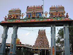 Sri Kandaswamy Temple | |
| Nickname(s): Mallai | |
 Mallasamudram Location in Tamil Nadu, India | |
| Coordinates: 11°28′48″N 78°1′48″E / 11.48000°N 78.03000°ECoordinates: 11°28′48″N 78°1′48″E / 11.48000°N 78.03000°E | |
| Country | |
| State | Tamil Nadu |
| District | Namakkal |
| Government | |
| • Panchayat president | Vacant |
| Elevation | 224 m (735 ft) |
| Population (2001) | |
| • Total | 17,181 |
| Languages | |
| • Official | Tamil |
| Time zone | UTC+5:30 (IST) |

Mallasamudram is a small town in Thiruchengode taluk, Namakkal district in the Indian state of Tamil Nadu. It is the headquarter of the Mallasamudram block. Mallasamudram is also known as "Mallai village", "Mallai".
Geography[]
Mallasamudram is about 25 km from Salem on the Salem - Tiruchengode Road, via Attayampatti. It has an average elevation of 22048 metres.
Demographics[]
As of 2001 India census,[1] Mallasamudram had a population of 17,125. Males constitute 51% of the population and females 49%. Mallasamudram has an average literacy rate of 62%, higher than the national average of 59.5%: male literacy is 70%, and female literacy is 53%. In Mallasamudram, 10% of the population is under 6 years of age. The town has many temples.
Economy[]
The major occupation of the people is textile Hand loom weaving, Agriculture & hotel .
Health[]
Government primary health center is situated in Mallasamudram to Pallipatti Main Road, Mallasamudram.
Education[]
There are elementary, primary, secondary as well as higher secondary schools in Mallasamudram. Mallasamudram has three private engineering colleges and a polytechnic college.
- Mahendra Engineering colleges,
- Mahendra Polytechnic college,
- Mahendra Arts & Science college.
- AKV Matriculation School
- AKV CBSE School
- Govt Boys Hr.Sec school
- Govt Girls Hr.Sec school
Distances[]
Tiruchengode -20 km
Namakkal -41 km
Rasipuram - 24 km
Salem - 25 km
Erode - 41 km
Sankagiri - 22 km
References[]
- ^ "Census of India 2001: Data from the 2001 Census, including cities, villages and towns (Provisional)". Census Commission of India. Archived from the original on 16 June 2004. Retrieved 1 November 2008.
| Wikimedia Commons has media related to Mallasamudram. |
This article related to a location in Namakkal district, Tamil Nadu, India is a stub. You can help Wikipedia by . |
- Cities and towns in Namakkal district
- Namakkal district geography stubs