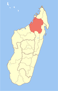
Mampikony
Mampikony | |
|---|---|
 Mampikony Location in Madagascar | |
| Coordinates: 16°5′30″S 47°38′50″E / 16.09167°S 47.64722°ECoordinates: 16°5′30″S 47°38′50″E / 16.09167°S 47.64722°E | |
| Country | |
| Region | Sofia |
| District | Mampikony |
| Elevation | 55 m (180 ft) |
| Population (2018)census | |
| • Total | 28,593 |
| Time zone | UTC3 (EAT) |
| Postal code | 414 |
Mampikony urban municipality in northern Madagascar. It belongs to the district of Mampikony, which is a part of Sofia Region. The population of the municipality was 28,593 in 2018.
Mampikony is located at the Route nationale 6 and served by the local Mampikony Airport. The town provides access to hospital services to its citizens.[2]
Geography[]
It is situated at 84 km from Ambondromamy on the Route nationale 6.
Religion[]
- FJKM - Fiangonan'i Jesoa Kristy eto Madagasikara (Church of Jesus Christ in Madagascar)
- FLM - Fiangonana Loterana Malagasy (Malagasy Lutheran Church)
- Roman Catholic church
- Adventist - ()
- Fiangonana APOKALIPSY (Apokalipsic Church)
Economy[]
Cotton and tobacco[3] plantations. The majority 75% of the population of the commune are farmers, while an additional 10% receives their livelihood from raising livestock. The most important crops are rice and onions; also cassava is an important agricultural product. Services provide employment for 15% of the population.[2]
A thermic central of Jirama is localized in this town.
Education[]
In addition to primary schooling the town offers secondary education at both junior and senior levels. A regional centre for distance education (CRTE) of the Centre National de Télé-Enseignement de Madagascar (CNETMAD) is also located in Mampikony.
References and notes[]
- ^ Estimated based on DEM data from Shuttle Radar Topography Mission
- ^ a b "ILO census data". Cornell University. 2002. Retrieved 2008-03-02.
- ^ Dilag-tours.ch - Mampikony
- Populated places in Sofia Region
- Tobacco in Madagascar

