Mananjary, Fianarantsoa
Mananjary | |
|---|---|
 Mananjary | |
 Mananjary Location in Madagascar | |
| Coordinates: 20°14′S 48°21′E / 20.233°S 48.350°E | |
| Country | |
| Region | Vatovavy |
| District | Mananjary |
| Elevation | 12 m (39 ft) |
| Population (2018) | |
| • Total | 25,222 |
| Time zone | UTC3 (EAT) |
| Code postal | 317 |

Mananjary is a city located in Vatovavy, Madagascar with a population of 25 222 inhabitants in 2018. It is the chief city of the Mananjary district.
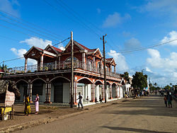
It contains a town of the same name, situated on the southern part of the east coast, where the Mananjary River flows into the Indian Ocean.[2] There's a small port and an airport.
Mananjary is situated at 130 km south of Nosy Varika on the RN 11[3] The Canal des Pangalanes divides the town into two sections.
Economy[]
Agriculture production is focused on vanilla, coffee, and pepper production.[4]
Religion[]
It is the seat of the Roman Catholic Diocese of Mananjary.
The small Antambahoaka tribe holds a ceremonial mass circumcision rite every seven years in the village, called "Sambatra."[5]
Education[]
- École primaire française de Mananjary[6]

Coordinates: 21°13′52″S 48°20′31″E / 21.23111°S 48.34194°E
References[]
- ^ Estimated based on DEM data from Shuttle Radar Topography Mission
- ^ www.britannica.com
- ^ Atlas Mondial, France Loisir, page 158
- ^ Madagascar & Comoros, pp. 230-31 (Lonely Planet, 2008)
- ^ Bradt, Hilary. Madagascar: The Bradt Travel Guide, p. 298 (2007)
- ^ "École primaire française de Mananjary." AEFE. Retrieved on May 7, 2015.
| Wikimedia Commons has media related to Mananjary. |
| Authority control |
|
|---|
- Cities in Madagascar
- Populated places in Vatovavy