Manatus Map
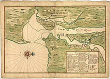

The Manatus Map is a 1639 city map of New Amsterdam and other New Netherland settlements surrounding New York Harbor, with pictorial elements, and bearing the title Manatus on the North River. Drafted during the period of Willem Kieft's directorship, its authorship disputed. Edward Van Winkle of the Holland Society of New York attributed it to the Dutch cartographer Johannes Vingboons, who made many manuscript maps for the West India Company.[1] According to Isaac Newton Phelps Stokes, Vingboons was among several possible creators, and only excludes Andries Hudde as the likely cartographer, as he was in a different part of the world at the time.[2]
The original drawing is lost and It survives only in two later 17th century copies made in the same studio with slight differences, as noted in Stokes' The Iconography of Manhattan Island.[2] One of the copies came from the same collection as the Castello Plan at Villa di Castello, the other from a Henry Harrisse donation to the Library of Congress. The Harrisse copy is twenty-six and five-eighth inches by eighteen and one-fourth inches in size and shows Manhattan Island with Westchester and Bronx Counties on the North; a good part of Long Island on the East; the Bay, Sant Punt, and Hoogen Hoeck on the South; with Staten Island, Achter t' Col, Newark Bay, the Hackensack and Passaic Rivers on the West. Sufficient of the surrounding country is shown to give a good idea of the comparative importance of the Island of Manhattan and its location with respect to the mainland.[1] It also includes an inset with the names of early Manhattan settlers.[1]
See also[]
References[]
- ^ a b c Van Winkle, Edward (1916). Manhattan, 1624-1639. The Knickerbocker Press.
 This article incorporates text from this source, which is in the public domain.
- ^ a b Stokes, Isaac Newton Phelps. "The Manatus Maps". The iconography of Manhattan Island, 1498-1909. New York: Robert H. Dodd.
External links[]
- The Manatus Maps, The Iconography of Manhattan Island
This cartography or mapping term article is a stub. You can help Wikipedia by . |
This New York City–related article is a stub. You can help Wikipedia by . |
- 1639 works
- 17th-century maps and globes
- History of New York City
- Maps of cities
- Maps of New York City
- New York (state) maps
- Cartography stubs
- New York City stubs