Manatuto
show This article may be expanded with text translated from the corresponding article in German. (November 2010) Click [show] for important translation instructions. |
Manatuto | |
|---|---|
Town | |
 | |
 Manatuto Location in East Timor | |
| Coordinates: 8°30′44″S 126°00′57″E / 8.51222°S 126.01583°ECoordinates: 8°30′44″S 126°00′57″E / 8.51222°S 126.01583°E | |
| Country | |
| Municipality | Manatuto |
| Administrative post | Manatuto |
| Area | |
| • Total | 271.38 km2 (104.78 sq mi) |
| Elevation | 0 m (0 ft) |
| Population (2010) | |
| • Total | 3,692 |
| • Density | 14/km2 (35/sq mi) |
| Time zone | UTC+09:00 (TLT) |
| Climate | BSh |

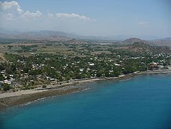
Manatuto is a city of Manatuto District, East Timor.
Manatuto Vila has 3,692 inhabitants (Census 2015) and is capital of the subdistrict and district Manatuto. It is on the north coast of Timor, located 64 km to the east of Dili, the national capital, on the way to Baucau. The capital is known for its salt production and abundance of tamarind.
The town of Manatuto suffered an excessive amount of damage and high murder rate in 1999 compared to other locations.[citation needed] The town is still being re-built.[citation needed]
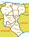
Map of Manatuto district

Climate[1]


References[]
External links[]
![]() Media related to Manatuto (city) at Wikimedia Commons
Media related to Manatuto (city) at Wikimedia Commons
| show Capitals of Municipalities of East Timor |
|---|
This East Timor location article is a stub. You can help Wikipedia by . |
Categories:
- Populated places in East Timor
- Manatuto Municipality
- East Timor geography stubs