Manchecourt
Manchecourt | |
|---|---|
Part of Le Malesherbois | |
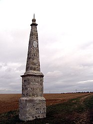 A Paris meridian marker in Manchecourt | |
show Location of Manchecourt | |
 Manchecourt | |
| Coordinates: 48°14′21″N 2°20′30″E / 48.2392°N 2.3417°ECoordinates: 48°14′21″N 2°20′30″E / 48.2392°N 2.3417°E | |
| Country | France |
| Region | Centre-Val de Loire |
| Department | Loiret |
| Arrondissement | Pithiviers |
| Canton | Malesherbes |
| Commune | Le Malesherbois |
| Area 1 | 16.23 km2 (6.27 sq mi) |
| Population (2017)[1] | 725 |
| • Density | 45/km2 (120/sq mi) |
| Time zone | UTC+01:00 (CET) |
| • Summer (DST) | UTC+02:00 (CEST) |
| Postal code | 45300 |
| Elevation | 107–138 m (351–453 ft) |
| 1 French Land Register data, which excludes lakes, ponds, glaciers > 1 km2 (0.386 sq mi or 247 acres) and river estuaries. | |


Manchecourt (French pronunciation: [mɑ̃ʃkuʁ]) is a former commune in the Loiret department in north-central France. On 1 January 2016, it was merged into the new commune of Le Malesherbois.[2]
See also[]
- Communes of the Loiret department
References[]
| Wikimedia Commons has media related to Manchecourt. |
This Loiret geographical article is a stub. You can help Wikipedia by . |
Categories:
- Former communes of Loiret
- Loiret geography stubs