Mangatangi
Mangatangi | |
|---|---|
Locality | |
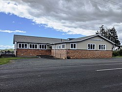 Mangatangi Hall | |
 | |
| Coordinates: 37°12′04″S 175°11′56″E / 37.201°S 175.199°ECoordinates: 37°12′04″S 175°11′56″E / 37.201°S 175.199°E | |
| Country | New Zealand |
| Region | Waikato |
| District | Waikato District |
| Elevation | 60 m (200 ft) |
| Population (2018 census) | |
| • Total | 441 |
| Time zone | UTC+12 (NZST) |
| • Summer (DST) | UTC+13 (NZDT) |

Mangatangi is a locality about 7 km east of Mangatawhiri and 10.5 km west of Miranda in the Waikato District in the North Island of New Zealand.
Mangatangi is in meshblocks 0841200 (NW), 0841300 (NE) and 0932801 (S), which had a combined population of 441 people in the 2018 New Zealand census.[1]
Mangatangi Reservoir in the Hunua Ranges to the north was created by the Mangatangi Dam, a rolled earth water supply dam built in the 1970s.[2] The Mangatangi River flows south from the reservoir to become the Maramarua River.
The New Zealand Ministry for Culture and Heritage gives a translation of "Stream of Weeping" for Mangatangi.[3]
The Mangatangi Hall on Kaiaua Road was opened in 1940 and extended in 1960. It contains the Mangatangi-Miranda roll of honour for local people who fought in the Second World War.[4]
Demographics[]
| Year | Pop. | ±% p.a. |
|---|---|---|
| 2006 | 858 | — |
| 2013 | 930 | +1.16% |
| 2018 | 1,083 | +3.09% |
| Source: [5] | ||
The statistical area of Mangatangi, which at 258 square kilometres is much larger than the locality, also includes Mangatawhiri. It had a population of 1,083 at the 2018 New Zealand census, an increase of 153 people (16.5%) since the 2013 census, and an increase of 225 people (26.2%) since the 2006 census. There were 339 households. There were 585 males and 498 females, giving a sex ratio of 1.17 males per female. The median age was 34.3 years, with 279 people (25.8%) aged under 15 years, 207 (19.1%) aged 15 to 29, 495 (45.7%) aged 30 to 64, and 108 (10.0%) aged 65 or older.
Ethnicities were 80.9% European/Pākehā, 18.3% Māori, 7.5% Pacific peoples, 3.6% Asian, and 2.8% other ethnicities (totals add to more than 100% since people could identify with multiple ethnicities).
The proportion of people born overseas was 16.3%, compared with 27.1% nationally.
Although some people objected to giving their religion, 59.6% had no religion, 32.1% were Christian, 0.8% were Hindu, and 1.7% had other religions.
Of those at least 15 years old, 120 (14.9%) people had a bachelor or higher degree, and 141 (17.5%) people had no formal qualifications. The median income was $39,800. The employment status of those at least 15 was that 483 (60.1%) people were employed full-time, 114 (14.2%) were part-time, and 30 (3.7%) were unemployed.[5]
Marae[]
The Mangatangi Marae and Marae Kirikiri meeting house is a traditional meeting ground of Ngāti Tamaoho and the Waikato Tainui hapū of Ngāi Tai and Ngāti Koheriki.[6][7]
In October 2020, the Government committed $2,584,751 from the Provincial Growth Fund to upgrade the marae and 7 other Waikato Tainui marae, creating 40 jobs.[8]
Education[]
Mangatangi School is a co-educational state full primary school covering years 1 to 8,[9] with a roll of 111 as of November 2021.[10] The school opened in 1919.[11]
References[]
- ^ "Meshblock Electoral Populations 2020 for proposed boundaries data". Statistics New Zealand. April 2020. Meshblocks 0841200, 0841300 and 0932801.
- ^ "Mangatangi Dam". Engineering New Zealand. Retrieved 31 August 2019.
- ^ "1000 Māori place names". New Zealand Ministry for Culture and Heritage. 6 August 2019.
- ^ "Mangatangi-Miranda roll of honour". New Zealand Ministry for Culture and Heritage. 30 April 2014.
- ^ a b "Statistical area 1 dataset for 2018 Census". Statistics New Zealand. March 2020. Mangatangi (169800). 2018 Census place summary: Mangatangi
- ^ "Te Kāhui Māngai directory". tkm.govt.nz. Te Puni Kōkiri.
- ^ "Māori Maps". maorimaps.com. Te Potiki National Trust.
- ^ "Marae Announcements" (Excel). growregions.govt.nz. Provincial Growth Fund. 9 October 2020.
- ^ Education Counts: Mangatangi School
- ^ "New Zealand Schools Directory". New Zealand Ministry of Education. Retrieved 22 December 2021.
- ^ "About Us - History". Mangatangi School. Retrieved 31 August 2019.
- Waikato District
- Populated places in Waikato