Manuk
| Manuk | |
|---|---|
| Highest point | |
| Elevation | 282 m (925 ft)[1] |
| Coordinates | 5°32′38″S 130°18′19″E / 5.5439°S 130.3054°ECoordinates: 5°32′38″S 130°18′19″E / 5.5439°S 130.3054°E |
| Geography | |
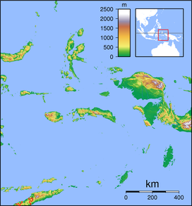
| Location | Banda Sea, Indonesia |
| Geology | |
| Mountain type | Stratovolcano |

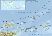
Manuk Island in the north east of the Barat Daya Islands
Manuk is an uninhabited volcanic island located in the Banda Sea, Indonesia. Administratively it is part of the Maluku Tengah Regency, Maluku Province.[2]
Manuk means bird in various Austronesian languages.
Mount Manuk[]
Mount Manuk is a truncated andesitic volcano on Manuk Island. Rising 3,000 m from the sea floor, it is the easternmost volcano of the Banda Arc chain that forms a volcanic island. No confirmed historical eruptions are known from Manuk.[1]
See also[]
References[]
- ^ Jump up to: a b "Manuk". Global Volcanism Program. Smithsonian Institution. Retrieved 2021-06-24.
- ^ Maluku Tengah Regency
This article about a location in Maluku Province is a stub. You can help Wikipedia by . |
Categories:
- Uninhabited islands of Indonesia
- Volcanoes of the Lesser Sunda Islands
- Stratovolcanoes of Indonesia
- Active volcanoes
- Barat Daya Islands
- Islands of the Maluku Islands
- Maluku (province) geography stubs