Marahoué
Marahoué Region
Région de la Marahoué | |
|---|---|
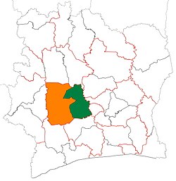 Location of Marahoué Region (green) in Ivory Coast and in Sassandra-Marahoué District | |
| Country | |
| District | Sassandra-Marahoué |
| 1997 | Established as a first-level subdivision |
| 2000 | Divided to create Fromager Region |
| 2011 | Converted to a second-level subdivision |
| Regional seat | Bouaflé |
| Government | |
| • Prefect | Kouamé Adrien Gbamélé |
| • Council President | Richmond Abi Koffi |
| Area | |
| • Total | 9,092 km2 (3,510 sq mi) |
| Population (2014)[3] | |
| • Total | 862,344 |
| • Density | 95/km2 (250/sq mi) |
| Time zone | UTC+0 (GMT) |
Marahoué Region is one of the 31 regions of Ivory Coast and is one of two regions in Sassandra-Marahoué District. The region's seat is Bouaflé. The region's area is 9,092 km²,[2][4] and its population in the 2014 census was 862,344.[3]
Departments[]
Marahoué Region is currently divided into three departments: Bouaflé, Sinfra, and Zuénoula.
History[]

Marahoué Region was created in 1997 as a first-level administrative region of the country. In 2000, Oumé Department was split off from Marahoué and combined with Gagnoa Department from Haut-Sassandra Region to form Fromager Region.
As part of the 2011 administrative reorganisation of the subdivisions of Ivory Coast, Marahoué was converted into a second-level administrative region and became part of the new first-level Sassandra-Marahoué District.[5] No territorial changes were made to Haut-Sassandra as a result of the reorganisation.
Notes[]
- ^ "Préfets de Région et de Préfets de Département (Conseil des ministres du mercredi 26 septembre 2012)", abidjan.net, 2 October 2012.
- ^ Jump up to: a b "Découverte de la Marahoué" Archived 2016-06-04 at the Wayback Machine, ardci-rd.org, accessed 23 February 2016.
- ^ Jump up to: a b "Côte d'Ivoire". geohive.com. Archived from the original on 22 November 2015. Retrieved 5 December 2015.
- ^ Since 2000. From 1997 to 2000, the area was greater.
- ^ Décret n° 2011-263 du 28 septembre 2011 portant organisation du territoire national en Districts et en Régions.

| show Regions of Ivory Coast (pre-2011) |
|---|
| Authority control |
|
|---|

- Marahoué
- Regions of Sassandra-Marahoué District
- 1997 establishments in Ivory Coast
- States and territories established in 1997