Marcelo Fernan Bridge
Marcelo Fernan Bridge | |
|---|---|
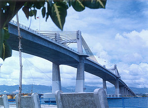 Marcelo Fernan Bridge, as seen from Mactan. | |
| Coordinates | 10°19′35.6″N 123°57′59.4″E / 10.326556°N 123.966500°ECoordinates: 10°19′35.6″N 123°57′59.4″E / 10.326556°N 123.966500°E |
| Carries | 4 lanes of |
| Crosses | Mactan Channel |
| Locale | Metro Cebu |
| Other name(s) | Second Cebu-Mactan Bridge (locally known) Consolacion Bridge (formerly) |
| Named for | Marcelo Fernan |
| Maintained by | Department of Public Works and Highways |
| Characteristics | |
| Design | Cable-stayed bridge |
| Total length | 1,230.2 m (4,036 ft)[1] |
| Longest span | 185 m (607 ft) |
| History | |
| Construction start | 1996 |
| Construction end | 1999 |
| Opened | August 3, 1999[2] |
| Location | |
 | |


Marcelo Fernan Bridge, also known as Second Cebu-Mactan Bridge is an extradosed cable-stayed bridge located in Metro Cebu in the Philippines. It spans across Mactan Channel connecting Mandaue City to Lapu-Lapu City in Mactan Island. It is currently the longest cable-stayed bridge in the Philippines Before it was named the Marcelo Fernan Bridge, it was called the Consolacion Bridge (which was a temporary name), named after the Municipality of Consolacion, which is 1.6 miles (2.6 km) from the north end of the bridge.
History[]
Marcelo Fernan Bridge was opened in August 1999 to decongest the traffic from the older Mactan–Mandaue Bridge. The bridge has a total length of 1,237 meters (4,058 ft) with a center span of 185 meters (607 ft), and was completed and inaugurated by President Joseph Estrada on August 3, 1999.[3] The bridge is one of the widest and longest bridge spans in the Philippines. The bridge was constructed with the help of the Japanese Government. It was named after Senator Marcelo Fernan, a political figure from Cebu City.
Additional information[]
On the Mactan Island side of the bridge, there is a park called the Millennium Park at the base of the bridge's piers, and the Filipino Seafarers Memorial is located in that park. Also, the bridge has two pedestrian walkways, one on the north side of the bridge, and one on the south side. On the Cebu Island side of the bridge, there is Mandaue City, and the bridge is accessed via United Nations Avenue. The Mactan Island side of the bridge, which is in Lapu-Lapu City, is accessed by Old Patiller Road, a spur road of the Manuel L. Quezon National Highway.
The bridge also sits astride the northern end of the Mactan Channel, which is a gateway to the Cebu International Port which is managed by the Cebu Port Authority, where about 80% of domestic and international shipping operators and shipbuilders in the Philippines are located. The Mactan-Mandaue Bridge is located about 1.6 kilometers (1 mile) south of the Marcelo Fernan Bridge.
See also[]
References[]
- ^ "List of National Bridge with length, type and condition per District Engineering Office as of 27 December 2019 - Cebu 6th District". Department of Public Works and Highways. Retrieved 21 March 2021.
- ^ "Marcelo Fernan Bridge repair to start Monday". The Freeman. Retrieved 2018-12-01.
- ^ "History of Lapulapu City". Recorded Events. The Lapu-lapu City Government Website. Archived from the original on 2007-12-17. Retrieved 2008-04-23.
External links[]
- Marcelo Fernan Bridge @ Structurae
 Media related to Marcelo Fernan Bridge at Wikimedia Commons
- WebSite for Mandaue City
- WebSite for Lapu-Lapu City
- Picture of the Filipino Seafarers Memorial.
- Picture of the Millenium Park under the bridge and another picture as well.
Cable-stayed bridges in Southeast Asia | ||
|---|---|---|
| Brunei |  | |
| Cambodia | ||
| Indonesia | ||
| Malaysia | ||
| Philippines | ||
| Thailand | ||
| Vietnam | ||
Cable-stayed bridges by country | ||
- Extradosed bridges
- Extradosed bridges in the Philippines
- Landmarks in the Philippines
- Cable-stayed bridges in the Philippines
- Transportation in Cebu
- Buildings and structures in Cebu
- Buildings and structures in Metro Cebu