Marine Corps Air Station Kaneohe Bay
| Marine Corps Air Station Kaneohe Bay | |||||||
|---|---|---|---|---|---|---|---|
Marion E. Carl Field | |||||||
| Part of Marine Corps Base Hawaii | |||||||
| Near Kaneohe, Hawaii in the United States | |||||||
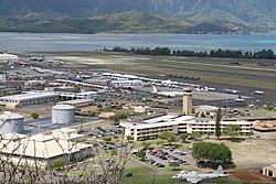 An aerial view of MCAS Kaneohe Bay during 2010. | |||||||
 MCAS Kaneohe Bay Location in Hawaii | |||||||
| Coordinates | 21°26′45″N 157°46′11″W / 21.44583°N 157.76972°WCoordinates: 21°26′45″N 157°46′11″W / 21.44583°N 157.76972°W | ||||||
| Type | Marine Corps Air Station | ||||||
| Site information | |||||||
| Owner | Department of Defense | ||||||
| Operator | US Marine Corps | ||||||
| Controlled by | 1st Marine Aircraft Wing | ||||||
| Condition | Operational | ||||||
| Website | www.mcbhawaii.marines.mil | ||||||
| Site history | |||||||
| Built | 1939 | ||||||
| In use | 1939 – 1949 (US Navy) 1952 – present (US Marine Corps) | ||||||
| Garrison information | |||||||
| Current commander | Lieutenant Colonel Tyler J. Holland | ||||||
| Garrison | Marine Aircraft Group 24 | ||||||
| Airfield information | |||||||
| Identifiers | IATA: NGF, ICAO: PHNG, FAA LID: NGF, WMO: 911760 | ||||||
| Elevation | 7 metres (23 ft) AMSL | ||||||
| |||||||
| Source: Airnav.com[1] | |||||||
U.S. National Register of Historic Places | |||||||
| Official name | Kaneohe Naval Air Station | ||||||
| Designated | 28 May 1987 | ||||||
| Reference no. | 87001299[2] | ||||||
| Period | 1900– | ||||||
| Area of significance | Military | ||||||

Marine Corps Air Station Kaneohe Bay or MCAS Kaneohe Bay (IATA: NGF, ICAO: PHNG, FAA LID: NGF) is a United States Marine Corps airfield located within the Marine Corps Base Hawaii complex, formerly known as Marine Corps Air Facility (MCAF) Kaneohe Bay or Naval Air Station (NAS) Kaneohe Bay.[3] It is located two miles (3 km) northeast of the central business district of Kaneohe, in Honolulu County, Hawaii, United States. The airfield has one runway (4/22) with a 7,771 x 200 ft (2,369 x 61 m) asphalt surface.[4]
History[]
Fort Hase and NAS Kaneohe Bay[]
The United States Army acquired 322 acres (1.30 km2) of the peninsula when President Woodrow Wilson signed executive order 2900 establishing the Kuwaaohe Military Reservation. Little is known about the operations of the fort, however, at the end of World War I, the military property was leased for ranching. In 1939, Kuwaaohe was reactivated, subjected to many name changes to include Camp Ulupa’u, and eventually named Fort Hase.
Prior to and during World War II, Fort Hase grew from a humble beginning as a defense battalion to a major unit of the Windward Coastal Artillery Command. Navy planners began to eye the peninsula in 1939 as the home of a strategic seaplane base. They liked the isolated location, the flat plains for an airfield and the probability of flights into prevailing trade winds. In 1939, the Navy acquired 464 acres (1.88 km2) of the peninsula for use of the PBY Catalina patrol seaplanes for long-range reconnaissance flights. One year later, the Navy owned all of the Mokapu Peninsula except for Fort Hase. In 1939 the Navy awarded a base construction contract to the Pacific Naval Air Base Contractors consortituim (PNABC).[5] Most of the original contract work at Kaneohe had been completed when the Navy transferred what was undone to the Seabees of the 56th Naval Construction Battalion on 1 April 1943.[5] The 112th CB was tasked with adding a second runway 400' x 5,000' to the airfield. That was completed by the men of the 74th CB.[5]

December 7, 1941, the Imperial Japanese Navy attacked the air station minutes prior to the attack on Pearl Harbor. Of the 36 Catalinas stationed here, 27 were destroyed and six others were damaged, along with 18 sailors who perished in the attack. The first Japanese aircraft destroyed in action were shot down at Kaneohe, along with Aviation Ordnanceman Chief Petty Officer John William Finn becoming one of the first Medal of Honor recipients of World War II for valor on that day.
During the war, the air station was a major training base in the Pacific Theater. The Fleet Gunnery School trained thousands of Navy gunners. There was a school for celestial navigation, sonar, aircraft recognition, and turret operations. Flight instructors also trained Navy and Marine Corps aviators in flight operations prior to being sent to a forward combat area. Following the war, Fort Hase had become a skeleton outpost and the air station consisted of limited air operations, a small security detachment, and a federal communications center.
In November 1958 the first of the Pacific Missile Impact Location System for the Navy's Pacific Missile Range (PMR) was operational at the station to monitor Intermediate Range Ballistic Missile (IRBM) test impacts northeast of Hawaii.[6][7]
Marine Operations[]

In 1949, the Navy decommissioned the air station. On January 15, 1952 the Marine Corps recommissioned the idle airfield Marine Corps Air Station Kaneohe Bay, making it an ideal training site for a combined air/ground team.[8] Station Operations and Headquarters Squadron supported flight operations until June 30, 1972, when Station Operations and Maintenance Squadron was commissioned in its place. SOMS served until it was disbanded on July 30, 1994. Marine Corps Air Facility Kaneohe Bay was formed on that date and continues today to serve the operational needs of the aviation community.
On May 28, 1987, the station was listed as a historic district on the National Register of Historic Places and a National Historic Landmark, in recognition of its role in World War II.[9][10][11]
Following the 1993 Base Realignment and Closure Commission decision to close Naval Air Station Barbers Point, the base acquired 4 Navy P-3 Orion patrol squadrons and one SH-60 Seahawk Anti-Submarine squadron in 1999. Today there are almost 10,000 active duty Navy and Marine Corps personnel there, directed by Marine Aircraft Group 24 and Navy Patrol and Reconnaissance Wing 2.
The installation was re-designated as an Air Station (vice an Air Facility) in May 2009.[12] At the same time, the airfield was named for MajGen Marion Eugene Carl, and the Corps announced that new squadrons would be stationed there.
On January 15, 2016, two Marine helicopters from the air station collided over the North Shore of Oahu, leaving 12 US Marines missing and feared dead.[13]
Based units[]
Flying and notable non-flying units based at MCAS Kaneohe Bay.[14]
United States Marine Corps[]
Marine Corps Installations – Pacific
- Headquarters and Headquarters Squadron – C-20G Gulfstream IV
[]
- Commander, Helicopter Maritime Strike Wing Pacific (CHMSWP)
- Commander, Patrol and Reconnaissance Wing 10 (CPRW-10)
- Special Projects Patrol Squadron 2 (VPU-2) – P-3C Orion
- Commander, Fleet Logistics Support Wing (CFLSW)
Insignia[]

Old MCAS Kaneohe Bay insignia 
Old MCAS Kaneohe Bay patch


See also[]
- List of National Historic Landmarks in Hawaii
- National Register of Historic Places listings in Oahu
- List of United States Marine Corps installations
- List of airports in Hawaii
References[]
- ^ "PHNG Kaneohe Bay Marine Corps Air Station (Marion E Carl Field)". Airnav.com. 21 May 2020. Retrieved 12 June 2020.
- ^ "Hawaii NHL Kaneohe Naval Air Station". National Archives Catalog.
- ^ MCAS Kaneohe Bay Archived 2010-12-21 at the Wayback Machine, official website, retrieved 2011-4-11
- ^ FAA Airport Form 5010 for NGF PDF, effective 2007-10-25
- ^ Jump up to: a b c Building the Navys Bases in World War II, History of the Bureau of Yards and Docks and Civil Engineering Corps, 1940-46, Chapter XXII, Pearl Harbor, part 1, Oahu, p.[1]
- ^ Subcommittee on Military Construction (March–April) (April 29, 1959). Military Construction Appropriations for 1960: Hearings. pp. 169–170. Retrieved 16 September 2020.
- ^ Subcommittee on Military Construction (May) (May 20, 1959). Military Construction Appropriations for 1960: Hearings. pp. 818, 824. Retrieved 16 September 2020.
- ^ "Air Station Salutes". Hawaii Marine. 11 (2). Marine Corps Base Hawaii. January 13, 1982. p. 4. Retrieved January 13, 2021.
- ^ "Kaneohe Naval Air Station". National Historic Landmark summary listing. National Park Service. Archived from the original on 2007-03-01. Retrieved 2008-07-04.
- ^ "NPS Form 10-900: National Register of Historic Places Inventory Nomination Form". National Register of Historic Places. National Park Service. June 17, 1986. Retrieved 21 March 2011.
- ^ "NPS Form 10-900; attached photos". National Register of Historic Places. National Park Service. June 17, 1986. Retrieved 21 March 2011.
- ^ "K-Bay gets new name, status". Honolulu Advertiser. Marine Corps Times. 2009-05-25. Archived from the original on 2012-02-23. Retrieved 2009-05-27.
- ^ "12 feared dead in military helicopter crash in Hawaii". United Press International. 2016-01-15. Retrieved 2016-01-15.
- ^ Kaminski, Tom (2019). "Aircraft of the US Marine Corps". US Navy & Marine Corps Air Power Yearbook 2019. Key Publishing. pp. 78–99.
External links[]
| Wikimedia Commons has media related to Marine Corps Air Station Kaneohe Bay. |
- Official website
- USMC Air Station Kaneohe Bay Overview & PCS Information (MarineCorpsUSA.org)
- Historic American Buildings Survey (HABS) No. HI-311-A, "U.S. Marine Corps Base Hawaii, Kaneohe Bay, Hangar No. 4, First Street between A & B Streets, Kailua, Honolulu County, HI", 11 photos, 12 data pages, 1 photo caption page
- Historic American Buildings Survey (HABS) No. HI-311-B, "U.S. Marine Corps Base Hawaii, Kaneohe Bay, Boat House, Southeast of intersection of Fueling Pier & D Street, Kailua, Honolulu County, HI", 5 photos, 5 data pages, 2 photo caption pages
- Historic American Buildings Survey (HABS) No. HI-311-C, "U.S. Marine Corps Base Hawaii, Kaneohe Bay, Stables, Mokapu & Summer Roads, Kailua, Honolulu County, HI", 6 photos, 12 data pages, 2 photo caption pages
- Historic American Buildings Survey (HABS) No. HI-311-D, "U.S. Marine Corps Base Hawaii, Kaneohe Bay, Enlisted Men's Mess Hall, Corner of Third & F Streets, Kailua, Honolulu County, HI", 6 photos, 13 data pages, 2 photo caption pages
- Resources for this airport:
- FAA airport information for NGF
- AirNav airport information for PHNG
- FlightAware airport information and live flight tracker
- NOAA/NWS latest weather observations for PHNG
- SkyVector aeronautical chart for NGF
- Airport information for PHNG (FAA: NGF) at World Aero Data. Data current as of October 2006.
- Airport information for PHNG (FAA: NGF) at Great Circle Mapper.
- Kaneohe Bay on GlobalSecurity.org
- WWII Era Photos of Kaneohe Bay
| show |
|---|

| show Operational military installations in Hawaii |
|---|
| show U.S. National Register of Historic Places |
|---|
| show Authority control |
|---|
- United States Marine Corps air stations
- Military facilities in Hawaii
- Airports in Hawaii
- Buildings and structures in Honolulu County, Hawaii
- Transportation in Honolulu County, Hawaii
- Historic American Buildings Survey in Hawaii
- Forts on the National Register of Historic Places in Hawaii
- World War II on the National Register of Historic Places in Hawaii
- Military airbases established in 1939
- 1939 establishments in Hawaii
- Historic districts on the National Register of Historic Places in Hawaii
- National Register of Historic Places in Honolulu County, Hawaii
- National Historic Landmarks in Hawaii