Mariners' Harbor station
Mariners' Harbor | |||
|---|---|---|---|
| Former Staten Island Railway station | |||
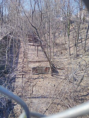 From Van Pelt Avenue overpass, 2020 | |||
| Station statistics | |||
| Borough | Staten Island | ||
| Locale | Mariners Harbor | ||
| Coordinates | 40°38′02″N 74°09′19″W / 40.6339°N 74.1552°WCoordinates: 40°38′02″N 74°09′19″W / 40.6339°N 74.1552°W | ||
| Division | [1] | ||
| Line | SIR North Shore Branch | ||
| Services | none | ||
| Platforms | 1 island platform | ||
| Tracks | 2 | ||
| Other information | |||
| Opened | Summer 1886 | ||
| Closed | March 31, 1953 | ||
| Former/other names | Erastina | ||
| Station succession | |||
| Next north | Harbor Road (demolished) | ||
| Next south | Lake Avenue | ||
| |||
| |||


Mariners' Harbor is a station on the abandoned North Shore Branch of the Staten Island Railway. It had two tracks (currently a single, abandoned and overgrown track) and one island platform. It is located in an open cut in the Staten Island neighborhood of Mariners Harbor at Van Pelt Avenue, about 4.6 miles (7.4 km) from the Saint George terminal.[2][3][4][5]
History[]
The station opened in summer 1886, as Erastina as part of an extension of the North Shore Branch west to Arlington. Buffalo Bill Cody named Erastina after Erastus Wiman,[6]: 167 who helped consolidate Staten Island's rail lines, and helped build Saint George Terminal, the North Shore Branch, and the South Beach Branch.[7] The nearby street Erastina Place retains this name today.[8] Vacant land nearby was used for staging Buffalo Bill’s “Wild West Show”, generating over 10,000 additional passengers from the St. George Ferry Terminal over the line. The neighborhood was renamed when he fell out of public favor due to scandal and bankruptcy.[9]
During the 1930s the station was depressed from grade-level into the current open cut,[10][11] rebuilt with a concrete island platform with a metal canopy extending across the platform's length.[5] A switch between the two tracks was located east of the station.[11]
The station was abandoned on March 31, 1953, along with the South Beach Branch and the rest of the North Shore Branch.[10][11] It is the westernmost station along the North Shore line which still stands as of 2010, although in unusable condition. The open-cut is overgrown, while the only remnants of the canopy are its support beams.[5][12] There is a closed gate to the station at Linden Avenue between Van Pelt Avenue and Maple Parkway.
Mariner's Harbor is one of the stations to be returned to operation under the proposals for reactivation of the North Shore branch for rapid transit, light rail, or bus rapid transit service.[3][4][5][8]
Station layout[]
| G | Street Level | - |
| P Former platform level |
Westbound | Trackbed |
| Island platform, not in use | ||
| Eastbound | Trackbed | |
References[]
- ^ "Glossary". Second Avenue Subway Supplemental Draft Environmental Impact Statement (SDEIS) (PDF). Vol. 1. Metropolitan Transportation Authority. March 4, 2003. pp. 1–2. Archived from the original (PDF) on February 26, 2021. Retrieved January 1, 2021.
- ^ Office of Diane J. Savino (2013). "State Senator Diane J. Savino's 2013 Staten Island Railway Rider Report" (PDF). nysenate.gov. New York State Senate. Retrieved July 31, 2015.
- ^ a b "North Shore Alternatives Analysis: Rail Alignment Drawings Arlington-St. George" (PDF). mta.info. Metropolitan Transportation Authority. September 2010. Retrieved July 20, 2015.
- ^ a b "NYCT NORTH SHORE ALTERNATIVES ANALYSIS: Alternatives Analysis Report" (PDF). mta.info. Metropolitan Transportation Authority. August 2012. Retrieved July 20, 2015.
- ^ a b c d "6.5: TRANSIT AND RAILROAD OPEN CUTS: STATEN ISLAND" (PDF). nyc.gov. New York City Department of City Planning. Archived from the original (PDF) on June 6, 2010. Retrieved August 6, 2015.
- ^ Wiman, Erastus (1893). Chances of Success: Episodes and Observations in the Life of a Busy Man. Trade supplied by the American News Company.
- ^ "Mariners Harbor Playground Highlights : NYC Parks".
- ^ a b "North Shore Alternatives Analysis May 2012" (PDF). streetsblog.org. Metropolitan Transportation Authority, SYSTRA. May 2012.
- ^ Rides and Rambles on Staten Island 1889
- ^ a b Leigh, Irvin; Matus, Paul (January 2002). "State Island Rapid Transit: The Essential History". thethirdrail.net. The Third Rail Online. Archived from the original on May 30, 2015. Retrieved June 27, 2015.
- ^ a b c Pitanza, Marc (2015). Staten Island Rapid Transit Images of Rail. Arcadia Publishing. ISBN 978-1-4671-2338-9.
- ^ "North Shore Alternatives Analysis: Public Meeting THURSDAY, APRIL 22, 2010 7:00 p.m." (PDF). zetlin.com. Metropolitan Transportation Authority. April 22, 2010. Archived from the original (PDF) on October 6, 2015. Retrieved July 31, 2015.
- North Shore Branch stations
- Railway stations in the United States opened in 1886
- Railway stations closed in 1953
- 1886 establishments in New York (state)
- 1953 disestablishments in New York (state)
- Mariners Harbor, Staten Island