Marj
Marj
المرج El Merj | |
|---|---|
City | |
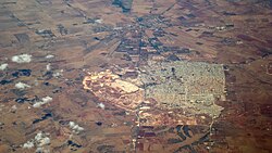 Old (above) and new city (below) | |
 Marj Location in Libya | |
| Coordinates: 32°29′12″N 20°50′02″E / 32.48667°N 20.83389°ECoordinates: 32°29′12″N 20°50′02″E / 32.48667°N 20.83389°E | |
| Libya | |
| Region | Cyrenaica |
| District | Marj |
| Elevation | 333 m (1,093 ft) |
| Population (2004)[1] | |
| • Total | 85,315 |
| Time zone | UTC+2 (EET) |

Marj /ˈmɑːrdʒ/ (Arabic: المرج, romanized: Al Marǧ, lit. 'The Meadows'), also spelt El Merj, generally believed to be on the site of the ancient city of Barca or Barce, is a city in northeastern Libya and the administrative seat of the Marj District.[2] It lies in an upland valley separated from the Mediterranean Sea by a range of hills, part of the Jebel Akhdar Mountains.
It has an estimated population of 85,315 (As of 2004).[1] There are a couple of banks on the main street and the main post office is in the city centre, not far from the Abu Bakr Assiddiq mosque.[3]
History[]


According to most archeologists, Marj marks the site of the ancient city of Barca, which, however, according to Alexander Graham, was at Tolmeita (Ptolemais).[4]
Marj grew around a Turkish fort built in 1842 and now restored. During the colonial dominance of Libya (1913–41), the town was called Barce and was developed as an administrative and market centre and hill resort.
During the World War II North African campaign, the 1st Field Regiment, Royal Australian Artillery won a battle for the region of Barce on 5 February 1941. The regiment commemorates this battle by naming the facilities at its base at Enoggera as Barce Lines.
From 1942–1943, the town was the capital of British-occupied Cyrenaica.[5]
Most of it was destroyed by a 5.6 earthquake on 21 February 1963,[3] which killed some 300 people and injured 500 more.[6] Major rebuilding was undertaken about 5 km (3.1 mi) from the old site, and was completed about 1970.
Transport[]
During the Italian colonization of Libya, Al Marj had been the eastern terminal of [it].
Nowadays, Al Marj is linked with Benghazi by two roads. One runs through Tocra (part of Libyan Coastal Highway). The other runs through Al Abyar.
Al Marj is linked also with Lamluda by two roads. One runs through Al Bayda (part of Libyan Coastal Highway). The other runs through Tacnis and Marawah. From Tacnis it leads to the Charruba–Timimi Road.
See also[]
Notes[]
- ^ Jump up to: a b c Wolfram Alpha
- ^ Room, Adrian (2006). Placenames of the World: Origins and Meanings of the Names for 6,600 Countries, Cities, Territories, Natural Features, and Historic Sites (2nd ed.). Jefferson, North Carolina: McFarland, Incorporated. p. 26. ISBN 978-0-7864-2248-7.
- ^ Jump up to: a b Pliez, Olivier (ed.) (2009) "Al Marj" Le Petit Futé Libye Petit Futé, Paris, p. 237, ISBN 2-7469-2276-2; in French
- ^ Graham, Alexander (1902) Roman Africa: an outline of the history of the Roman occupation of North Africa, based chiefly upon inscriptions and monumental remains in that country Longmans, Green, and Co., London, p. 312, OCLC 2735641
- ^ Stewart, John (1996) "Cyrenaica" The British Empire: an encyclopedia of the Crown's holdings, 1493 through 1995 McFarland & Co., Jefferson, North Carolina, p. 125, ISBN 0-7864-0177-X
- ^ Hewitt, Kenneth (1983) "Seismic Risk and Mountain Environments: The Role of Surface Conditions in Earthquake Disaster" Mountain Research and Development 3(1): pp. 27–44, p. 30
Further reading[]
- Hamilton, James (1856) Wanderings in North Africa J. Murray, London, OCLC 5659586
External links[]
| Wikimedia Commons has media related to Al Marj. |
| show Authority control |
|---|
- Marj
- Cyrenaica
- Cities destroyed by earthquakes
- Baladiyat of Libya