Marks, Russia
Marks
Маркс | |
|---|---|
Town[1] | |
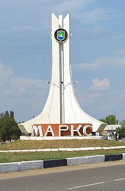 A stele at the entrance to Marks | |
 Coat of arms | |
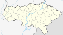
show Location of Marks | |
 Marks Location of Marks | |
| Coordinates: 51°43′N 46°45′E / 51.717°N 46.750°ECoordinates: 51°43′N 46°45′E / 51.717°N 46.750°E | |
| Country | Russia |
| Federal subject | Saratov Oblast[1] |
| Founded | 1767[2] |
| Town status since | 1918[3] |
| Elevation | 20 m (70 ft) |
| Population | |
| • Total | 31,531 |
| • Estimate (2018)[5] | 31,488 (−0.1%) |
Administrative status | |
| • Subordinated to | Marks Town Under Oblast Jurisdiction |
| • Capital of | Marksovsky District[6], Marks Town Under Oblast Jurisdiction |
Municipal status | |
| • Municipal district | Marksovsky Municipal District[7] |
| • Urban settlement | Marks Urban Settlement[7] |
| • Capital of | Marksovsky Municipal District[8], Marks Urban Settlement[7] |
| Time zone | UTC+4 (MSK+1 |
| Postal code(s)[10] | 413090, 413092, 413093 |
| Dialing code(s) | +7 84567[11] |
| OKTMO ID | 63626101001 |


Marks (Russian: Маркс), also spelled Marx, named after Karl Marx, is a town in Saratov Oblast, Russia, located 60 kilometers (37 mi) northeast of Saratov, the administrative center of the oblast. Population: 31,531 (2010 Census);[4] 32,849 (2002 Census);[12] 31,908 (1989 Census).[13]
It was previously known as Baronsk,[3] Yekaterinenshtadt (until 1920),[3] Marksshtadt (until 1941).[3]
History[]
It was founded in 1767 as a Volga German community called Baronsk (Баронск).[14] It was soon renamed Yekaterinenshtadt (Екатериненштадт; Jekaterinenstadt/Katharinenstadt; 1915 - 1920 Yekaterinograd), after Catherine the Great. In 1918, it was granted town status and in 1920 it was renamed Marksshtadt (Марксштадт; Marxstadt), after Karl Marx.[15] In 1941, during the resettlement of Germans, the town was given its present name.[citation needed]
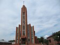
Christ the King Catholic church
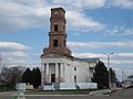
The old Lutheran church in 2015


Administrative and municipal status[]
Within the framework of administrative divisions, Marks serves as the administrative center of Marksovsky District,[6] even though it is not a part of it.[16] As an administrative division, it is incorporated separately as Marks Town Under Oblast Jurisdiction[16]—an administrative unit with the status equal to that of the districts.[citation needed] As a municipal division, Marks Town Under Oblast Jurisdiction is incorporated within Marksovsky Municipal District as Marks Urban Settlement.[7]
References[]
Notes[]
- ^ Jump up to: a b Charter of Saratov Oblast
- ^ "Where is Ekaterinenshtadt? Cities Of Russia, April 29, 2010". Retrieved June 7, 2018.
- ^ Jump up to: a b c d "Где находится Екатериненштадт? Города России".
- ^ Jump up to: a b Russian Federal State Statistics Service (2011). Всероссийская перепись населения 2010 года. Том 1 [2010 All-Russian Population Census, vol. 1]. Всероссийская перепись населения 2010 года [2010 All-Russia Population Census] (in Russian). Federal State Statistics Service.
- ^ "26. Численность постоянного населения Российской Федерации по муниципальным образованиям на 1 января 2018 года". Federal State Statistics Service. Retrieved January 23, 2019.
- ^ Jump up to: a b Государственный комитет Российской Федерации по статистике. Комитет Российской Федерации по стандартизации, метрологии и сертификации. №ОК 019-95 1 января 1997 г. «Общероссийский классификатор объектов административно-территориального деления. Код 63 226», в ред. изменения №278/2015 от 1 января 2016 г.. (State Statistics Committee of the Russian Federation. Committee of the Russian Federation on Standardization, Metrology, and Certification. #OK 019-95 January 1, 1997 Russian Classification of Objects of Administrative Division (OKATO). Code 63 226, as amended by the Amendment #278/2015 of January 1, 2016. ).
- ^ Jump up to: a b c d Law #97-ZSO
- ^ Law #78-ZSO
- ^ "Об исчислении времени". Официальный интернет-портал правовой информации (in Russian). June 3, 2011. Retrieved January 19, 2019.
- ^ Почта России. Информационно-вычислительный центр ОАСУ РПО. (Russian Post). Поиск объектов почтовой связи (Postal Objects Search) (in Russian)
- ^ "The international country phone code of Russia +7". Retrieved June 7, 2018.
- ^ Russian Federal State Statistics Service (May 21, 2004). Численность населения России, субъектов Российской Федерации в составе федеральных округов, районов, городских поселений, сельских населённых пунктов – районных центров и сельских населённых пунктов с населением 3 тысячи и более человек [Population of Russia, Its Federal Districts, Federal Subjects, Districts, Urban Localities, Rural Localities—Administrative Centers, and Rural Localities with Population of Over 3,000] (XLS). Всероссийская перепись населения 2002 года [All-Russia Population Census of 2002] (in Russian).
- ^ Всесоюзная перепись населения 1989 г. Численность наличного населения союзных и автономных республик, автономных областей и округов, краёв, областей, районов, городских поселений и сёл-райцентров [All Union Population Census of 1989: Present Population of Union and Autonomous Republics, Autonomous Oblasts and Okrugs, Krais, Oblasts, Districts, Urban Settlements, and Villages Serving as District Administrative Centers]. Всесоюзная перепись населения 1989 года [All-Union Population Census of 1989] (in Russian). Институт демографии Национального исследовательского университета: Высшая школа экономики [Institute of Demography at the National Research University: Higher School of Economics]. 1989 – via Demoscope Weekly.
- ^ Handbook for Travellers in Russia, Poland, and Finland. J. Murray. January 1, 1875.
- ^ "Where is Ekaterinenshtadt? Cities Of Russia, April 29, 2010". Retrieved June 7, 2018.
- ^ Jump up to: a b Государственный комитет Российской Федерации по статистике. Комитет Российской Федерации по стандартизации, метрологии и сертификации. №ОК 019-95 1 января 1997 г. «Общероссийский классификатор объектов административно-территориального деления. Код 63 422», в ред. изменения №278/2015 от 1 января 2016 г.. (State Statistics Committee of the Russian Federation. Committee of the Russian Federation on Standardization, Metrology, and Certification. #OK 019-95 January 1, 1997 Russian Classification of Objects of Administrative Division (OKATO). Code 63 422, as amended by the Amendment #278/2015 of January 1, 2016. ).
Sources[]
- Саратовская областная Дума. Закон №46-ЗСО от 2 июня 2005 г. «Устав (Основной Закон) Саратовской области», в ред. Закона №54-ЗСО от 28 апреля 2015 г. «О внесении изменений в Устав (Основной Закон) Саратовской области». Вступил в силу после официального опубликования. Опубликован: "Неделя области", Спецвыпуск, №38 (156), 4 июня 2005 г. (Saratov Oblast Duma. Law #46-ZSO of June 2, 2005 Charter (Basic Law) of Saratov Oblast, as amended by the Law #54-ZSO of April 28, 2015 On Amending the Charter (Basic Law) of Saratov Oblast. Effective as of after the official publication.).
- Саратовская областная Дума. Закон №79-ЗСО от 23 декабря 2004 г «О городских округах». Вступил в силу с 1 января 2005 г. Опубликован: "Саратов — столица Поволжья", №264 (1215), 24 декабря 2004 г. (Saratov Oblast Duma. Law #79-ZSO of December 23, 2004 On the Urban Okrugs. Effective as of January 1, 2005.).
- Саратовская областная Дума. Закон №97-ЗСО от 27 декабря 2004 г. «О муниципальных образованиях, входящих в состав Марксовского муниципального района», в ред. Закона №134-ЗСО от 2 августа 2012 г. «О внесении изменений в Закон Саратовской области "О муниципальных образованиях, входящих в состав Марксовского муниципального района"». Вступил в силу с 1 января 2005 г. Опубликован: "Саратов — столица Поволжья", №4–5 (1227–1228), 14 января 2005 г. (Saratov Oblast Duma. Law #97-ZSO of December 27, 2004 On the Municipal Formations Marksovsky Municipal District Comprises, as amended by the Law #134-ZSO of August 2, 2012 On Amending the Law of Saratov Oblast "On the Municipal Formations Marksovsky Municipal District Comprises". Effective as of January 1, 2005.).
External links[]
- Mojgorod.ru. Entry on Marks (in Russian)
| Authority control |
|---|
- Marks, Russia
- Cities and towns in Saratov Oblast
- Samara Governorate
- Populated places established in 1767
- German communities in Russia
- 1767 establishments in the Russian Empire
- Volga German people