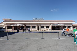
Marsa Matruh International Airport
Marsa Matruh International Airport مطار مرسى مطروح الدولي | |||||||||||||||
|---|---|---|---|---|---|---|---|---|---|---|---|---|---|---|---|
 | |||||||||||||||
| Summary | |||||||||||||||
| Airport type | Public | ||||||||||||||
| Operator | Government | ||||||||||||||
| Serves | Mersa Matruh, Egypt | ||||||||||||||
| Elevation AMSL | 94 ft / 29 m | ||||||||||||||
| Coordinates | 31°19′30″N 27°13′20″E / 31.32500°N 27.22222°E | ||||||||||||||
| Map | |||||||||||||||
 MUH Location of airport in Egypt | |||||||||||||||
| Runways | |||||||||||||||
| |||||||||||||||

Marsa Matruh International Airport, formerly Mersa Matruh Airport (Arabic: مطار مرسى مطروح الدولي) (IATA: MUH, ICAO: HEMM), is an international airport in Mersa Matruh, Egypt. In 2011, the airport served 99,515 passengers (−13.7% compared to 2010).
The Mersa Matruh VOR-DME (Ident: MMA) is located on the field.[4]
Airlines and destinations[]
| Airlines | Destinations |
|---|---|
| Animawings[5] | Seasonal: Bucharest |
Military operations[]
Mersa Matruh Air Base (possibly collocated with the civilian field) hosts the 102nd Tactical Fighter Brigade, with 26 Squadron flying the F-7 and FT-7 and an 82 Squadron detachment flying the Mirage 2000BM and 2000EM.
See also[]
References[]
- ^ "Airport information for HEMM". World Aero Data. Archived from the original on 5 March 2019.CS1 maint: unfit URL (link) Data current as of October 2006. Source: DAFIF.
- ^ Airport information for MUH at Great Circle Mapper.
- ^ Google Maps - Marsa Matruh
- ^ "SkyVector: Flight Planning / Aeronautical Charts". skyvector.com. Retrieved 20 August 2018.
- ^ "Flight schedule". animawings.com.
External links[]
- Current weather for HEMM at NOAA/NWS
- Accident history for MUH at Aviation Safety Network
- OurAirports - Mersa Matruh
- OpenStreetMap - Marsa Matruh
This article about an airport in Egypt is a stub. You can help Wikipedia by . |
Categories:
- Airports in Egypt
- Egyptian Air Force bases
- Mersa Matruh
- North African airport stubs
- Egypt transport stubs