Martin Peninsula
This article does not cite any sources. (December 2009) |
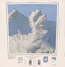
1:250,000 scale topographic map of the Martin Peninsula.
Martin Peninsula (74°20′S 114°30′W / 74.333°S 114.500°WCoordinates: 74°20′S 114°30′W / 74.333°S 114.500°W) is a peninsula about 96 km (60) mi long and 32 km (20 mi) wide that is ice-covered except for a few rock outcrops along its margins, located between Getz Ice Shelf and Dotson Ice Shelf on the coast of Marie Byrd Land, Antarctica. The farthest point of the peninsula is Jacobsen Head.
 WikiMiniAtlas
Delineated from aerial photographs taken by USN Operation Highjump in January 1947. Named by US-ACAN after Col. Lawrence Martin, USA (Ret.), American geographer and authority on Antarctic exploration with the Library of Congress; member of US-SCAN, 1943–46.
This Marie Byrd Land location article is a stub. You can help Wikipedia by . |
Categories:
- Peninsulas of Antarctica
- Landforms of Marie Byrd Land
- Marie Byrd Land geography stubs