Mas-d'Orcières
Mas-d'Orcières | |
|---|---|
Part of Mont Lozère et Goulet | |
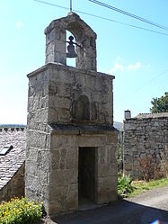 The , in Mas-d'Orcière | |
show Location of Mas-d'Orcières | |
 Mas-d'Orcières | |
| Coordinates: 44°28′49″N 3°42′30″E / 44.4803°N 3.7083°ECoordinates: 44°28′49″N 3°42′30″E / 44.4803°N 3.7083°E | |
| Country | France |
| Region | Occitanie |
| Department | Lozère |
| Arrondissement | Mende |
| Canton | Saint-Étienne-du-Valdonnez |
| Commune | Mont Lozère et Goulet |
| Area 1 | 36.56 km2 (14.12 sq mi) |
| Population (2017)[1] | 94 |
| • Density | 2.6/km2 (6.7/sq mi) |
| Time zone | UTC+01:00 (CET) |
| • Summer (DST) | UTC+02:00 (CEST) |
| Postal code | 48190 |
| Elevation | 1,000–1,699 m (3,281–5,574 ft) (avg. 1,070 m or 3,510 ft) |
| 1 French Land Register data, which excludes lakes, ponds, glaciers > 1 km2 (0.386 sq mi or 247 acres) and river estuaries. | |


Mas-d'Orcières (Occitan: Mas d'Aussièira) is a former commune in the Lozère department in southern France. On 1 January 2017, it was merged into the new commune Mont Lozère et Goulet.[2] Its population was 94 in 2017.[1]
See also[]
References[]
- ^ Jump up to: a b Téléchargement du fichier d'ensemble des populations légales en 2017, INSEE
- ^ Arrêté préfectoral 23 May 2016 (in French)
| Wikimedia Commons has media related to Mas-d'Orcières. |
This Lozère geographical article is a stub. You can help Wikipedia by . |
Categories:
- Former communes of Lozère
- Lozère geography stubs