Masohi
This article needs additional citations for verification. (October 2011) |
Masohi | |
|---|---|
Town | |
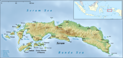 Masohi Location in Seram Island | |
| Coordinates: 3°17′56″S 128°57′58″E / 3.29889°S 128.96611°ECoordinates: 3°17′56″S 128°57′58″E / 3.29889°S 128.96611°E | |
| Country | Indonesia |
| Province | Maluku |
| Regency | Central Maluku |
| Area | |
| • Total | 37.30 km2 (14.40 sq mi) |
| Population (2020 Census)[1] | |
| • Total | 36,433 |
| [2] | |
| Time zone | UTC+9 (WIT) |

Masohi is a coastal town on the Indonesian island of Seram. It is the capital of the Central Maluku Regency (Kebupaten Maluku Tengah). It was the site of a detention camp for political prisoners in the 1970s. It had 36,433 inhabitants at the 2020 Census.[3] The headquarters of Manusela National Park is located in Masohi.
Administrative villages (kelurahan)[]
The town comprises the five urban villages or kelurahan (with their 2010 Census populations) of Ampera (5,558), Lesane (4,305), Letwaru (5,187), Namaelo (13,367) and Namasina (3,338).[4]
Christian-Muslim violence[]
The Maluku sectarian conflict impacted Masohi at the end of 1999 and in early 2000.[1] A fresh outbreak of violence occurred in 2008 in Masohi over alleged blasphemy by a teacher. Dozens of houses were burnt, as well as a church and a village hall. Five injuries were reported.[2][3][4][5]
Transportation[]
- Roads run east and west along the coast from Masohi. Another road goes over the mountains to on the north coast.
- An airport exists here, linking Masohi with Ambon and Banda.
- The sea port serves boats arriving from Ambon, Saparua and other parts of the Moluccas.
Around Masohi[]
Points of interest include the cave Goa Akohi (near Tamilouw village) and a small lake, Ihu Allah.
External links[]
References[]
- Central Maluku Regency
- Populated places in Seram Island
- Regency seats of Maluku (province)