Massif des Écrins
show This article may be expanded with text translated from the corresponding article in French. (January 2013) Click [show] for important translation instructions. |
| Massif des Écrins | |
|---|---|
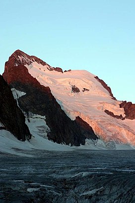 Barre des Écrins in early morning light, July 2006 | |
| Highest point | |
| Peak | Barre des Écrins |
| Elevation | 4,102 m (13,458 ft) |
| Coordinates | 44°55′23″N 6°21′36″E / 44.92306°N 6.36000°ECoordinates: 44°55′23″N 6°21′36″E / 44.92306°N 6.36000°E |
| Geography | |
 Principal summits of the Écrins, together with the national park boundaries
| |
| Country | France |
| Parent range | Dauphiné Alps |

The mountains of the Massif des Écrins (French: [ma.sif de.z‿e.kʁɛ̃]) form the core of the Écrins National Park in France.
Mountains[]
- Barre des Écrins 4102 m
- La Meije 3983 m
- Ailefroide 3954 m
- Mont Pelvoux 3946 m
- Pic Sans Nom 3913 m
- Pic Gaspard 3883 m
- Le Râteau 3809 m
- 3774 m
- La Grande Ruine 3765 m
- Roche Faurio 3730 m
- Les Bans 3669 m
- Les Agneaux 3663 m
- 3628 m
- Pic de Neige Cordier 3614 m
- Aiguille du Plat de la Selle 3597 m
- Les Rouies 3589 m
- Olan 3564 m
- 3564 m
- Tête de l'Etret 3559 m
- 3544 m
- 3533 m
- Pointe des Arcas 3478 m
- Roche de la Muzelle 3465 m
- 3460 m
- Tête des Fétoules 3459 m
- 3440 m
- Tête du Rouget 3435 m
- 3421 m
- 3419 m
- Aiguille des Arias 3403 m
- Pointe de l'Aiglière 3308 m
- 3294 m
- 3288 m
- 3242 m
- 3179 m
- Vieux Chaillol 3163 m
- Têtes des Vautisse 3156 m
- 3155 m
- Aiguille Dibona 3130 m
- Pic des Souffles 3098 m
- 3084 m
- 3080 m
- Le Rochail 3023 m
- 2883 m
- 2776 m
Glaciers[]
References[]
External links[]
- Massif des Écrins (in French)
- GR54 Hike in the Écrins (in Dutch)
| Authority control |
|---|
This Auvergne-Rhône-Alpes geographical article is a stub. You can help Wikipedia by . |
This Provence-Alpes-Côte d'Azur geography article is a stub. You can help Wikipedia by . |
Categories:
- Landforms of Isère
- Mountain ranges of Auvergne-Rhône-Alpes
- Mountain ranges of the Alps
- Mountains of Hautes-Alpes
- Mountain ranges of Provence-Alpes-Côte d'Azur
- Auvergne-Rhône-Alpes geography stubs
- Provence-Alpes-Côte d'Azur geography stubs