Mauban
Mauban | |
|---|---|
| Municipality of Mauban | |
     (From top, left to right:) Panoramic view of Mauban town center from Rizal Hill Park; Rizal Monument at Rizal Hill Park; Pansacola Ancestral House; Saint Bonaventure Parish Church; public bath built in 1725 | |
 Seal | |
 Map of Quezon with Mauban highlighted | |
OpenStreetMap  | |
 Mauban Location within the Philippines | |
| Coordinates: 14°11′28″N 121°43′51″E / 14.1911°N 121.7308°ECoordinates: 14°11′28″N 121°43′51″E / 14.1911°N 121.7308°E | |
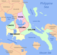
| Country | Philippines |
| Region | Calabarzon |
| Province | Quezon |
| District | 1st district |
| Founded | July 15, 1583 |
| Barangays | 40 (see Barangays) |
| Government | |
| • Type | Sangguniang Bayan |
| • Mayor | Marita T. Llamas |
| • Vice Mayor | Marivel M. Trinidad |
| • Representative | Wilfrido Mark M. Enverga |
| • Municipal Council | Members |
| • Electorate | 42,217 voters (2019) |
| Area | |
| • Total | 415.98 km2 (160.61 sq mi) |
| Elevation | 58 m (190 ft) |
| Highest elevation | 376 m (1,234 ft) |
| Lowest elevation | 0 m (0 ft) |
| Population (2020 census) [4] | |
| • Total | 71,081 |
| • Density | 170/km2 (440/sq mi) |
| • Households | 14,682 |
| Economy | |
| • Income class | 1st municipal income class |
| • Poverty incidence | 18.09% (2015)[5] |
| • Revenue | ₱662,018,017.17 (2020) |
| • Assets | ₱1,523,087,981.83 (2020) |
| • Expenditure | ₱424,779,440.67 (2020) |
| • Liabilities | ₱418,072,016.49 (2020) |
| Service provider | |
| • Electricity | Manila Electric Company (Meralco) |
| Time zone | UTC+8 (PST) |
| ZIP code | 4330 |
| PSGC | |
| IDD : area code | +63 (0)42 |
| Native languages | Tagalog |
| Website | www |
Mauban, officially the Municipality of Mauban (Tagalog: Bayan ng Mauban), is a 1st class municipality in the province of Quezon, Philippines. According to the 2020 census, it has a population of 71,081 people. [4]
It lies 157 kilometers (98 mi) southeast of Manila and some 52 kilometers (32 mi) north of Lucena City, the provincial capital.
Barangays[]
Mauban is politically subdivided into 40 barangays.
- Bagong Bayan (Poblacion)
- Daungan (Poblacion)
- Lual (Poblacion)
- Mabato (Poblacion)
- Rizaliana (Poblacion)
- Sadsaran (Poblacion)
- Abo-abo
- Alitap
- Baao
- Balaybalay
- Bató
- Cagbalete I
- Cagbalete II
- Cagsiay I
- Cagsiay II
- Cagsiay III
- Concepción
- Liwayway
- Lucutan
- Lual Rural
- Luya-luya
- Macasin
- Polo
- Remedios I
- Remedios II
- Rosario
- San Gabriel (formerly Tubog [6])
- San Isidro
- San José
- San Lorenzo
- San Miguel
- San Rafael
- San Roque
- San Vicente
- Santa Lucía
- Santo Ángel
- Santo Niño
- Santol
- Soledad
- Tapucan
Climate[]
| Climate data for Mauban, Quezon | |||||||||||||
|---|---|---|---|---|---|---|---|---|---|---|---|---|---|
| Month | Jan | Feb | Mar | Apr | May | Jun | Jul | Aug | Sep | Oct | Nov | Dec | Year |
| Average high °C (°F) | 26 (79) |
27 (81) |
29 (84) |
31 (88) |
31 (88) |
30 (86) |
29 (84) |
29 (84) |
29 (84) |
29 (84) |
28 (82) |
26 (79) |
29 (84) |
| Average low °C (°F) | 22 (72) |
22 (72) |
22 (72) |
23 (73) |
24 (75) |
24 (75) |
24 (75) |
24 (75) |
24 (75) |
24 (75) |
23 (73) |
23 (73) |
23 (74) |
| Average precipitation mm (inches) | 83 (3.3) |
55 (2.2) |
44 (1.7) |
37 (1.5) |
90 (3.5) |
123 (4.8) |
145 (5.7) |
125 (4.9) |
135 (5.3) |
166 (6.5) |
163 (6.4) |
152 (6.0) |
1,318 (51.8) |
| Average rainy days | 15.1 | 10.8 | 11.9 | 11.4 | 19.9 | 23.7 | 26.3 | 23.9 | 23.9 | 22.1 | 20.2 | 18.6 | 227.8 |
| Source: Meteoblue [7] | |||||||||||||
Demographics[]
| Year | Pop. | ±% p.a. |
|---|---|---|
| 1903 | 12,021 | — |
| 1918 | 12,516 | +0.27% |
| 1939 | 14,832 | +0.81% |
| 1948 | 14,417 | −0.31% |
| 1960 | 18,703 | +2.19% |
| 1970 | 29,822 | +4.77% |
| 1975 | 32,653 | +1.84% |
| 1980 | 37,814 | +2.98% |
| 1990 | 43,740 | +1.47% |
| 1995 | 47,442 | +1.53% |
| 2000 | 50,134 | +1.19% |
| 2007 | 55,866 | +1.50% |
| 2010 | 61,141 | +3.34% |
| 2015 | 63,819 | +0.82% |
| 2020 | 71,081 | +2.14% |
| Source: Philippine Statistics Authority [8] [9] [10][11] | ||
Economy[]
| Poverty Incidence of Mauban | |
| Source: Philippine Statistics Authority[12][13][14][15][16][17] | |
In 2000, the Quezon Power Project, a 440 megawatt coal power plant was constructed to bring consistent power to the area. It was the first privately built, owned, and operated power generating facility in the Philippines.[18]
Education[]
As of August 2008, the Department of Education lists 35 public schools in Mauban;[19] 29 are Elementary schools, while the remaining 6 are High Schools. The Elementary schools are divided into two districts: Mauban North and Mauban South.
Mauban North Elementary School District[]
- Balaybalay Elementary School
- Concepcion Elementary School
- Liwayway Elementary School
- Mabato Elementary School
- Mauban North Elementary School I
- Mauban North Elementary School II
- Remedios I Elementary School
- Remedios I Preschool (Annex) Bulusok
- Remedios II Elementary School
- San Lorenzo Elementary School
- San Miguel- San Rafael Elementary School
- SWA Elementary School
Mauban South Elementary School District[]
- Alitap Elementary School
- Bagong Bayan Elementary School
- Cagbalete I Annex Elementary School
- Cagbalete I Elementary School
- Cagbalete II (P.H. Dela Costa) Elementary School
- Cagsiay I Elementary School
- Cagsiay II Elementary School
- Cagsiay III Annex Elementary School
- Cagsiay III Elementary School
- Doña Aurora Elementary School
- Mauban South Central Elementary School I
- Mauban South Central Elementary School II
- Plaridel Elementary School
- Polo Elementary School
- Rosario Elementary School
- San Jose Elementary School
- Santa Lucia Elementary School
- Santo Niño Elementary School
High schools[]
- Cagbalete Island National High School
- Cagsiay I National High School
- Cagsiay III-Cagsiay I National High School Extension
- Dr. Maria D. Pastrana National High School (Mauban Science-Oriented High School)
- Liwayway National High School
- Manuel S. Enverga Memorial School of Arts and Trades (Quezon National School of Arts & Trades)
Mauban also has two private schools, Central Quezon Academy in Barangay Mabato[20] and Mother Perpetua Parochial School in Barangay Lual Poblacion.[21] It also has one college, Pambayang Kolehiyo ng Mauban.[22]
List of Cultural Properties of Mauban[]
| Cultural Property wmph identifier |
Site name | Description | Province | City/municipality | Address | Coordinates | Image |
|---|---|---|---|---|---|---|---|
| Spanish-Era Public Bath of Mauban | Built in 1725, the public bath was declared an Important Cultural Property by the National Museum of the Philippines | Quezon | Mauban, Quezon | San Buenaventura Street | 14°11′33″N 121°43′56″E / 14.192394°N 121.732338°E |  | |
| RAS Copra Mill | The first copra mill in the town, owned and operated by the Sardea Family since the 1970s | Quezon | Mauban, Quezon | 14°11′29″N 121°44′00″E / 14.191396°N 121.733333°E |  | ||
| 1925 Rizal Monument | Built on the town promontory called Calvario in 1925. | Quezon | Mauban, Quezon | 14°11′21″N 121°43′51″E / 14.189245°N 121.730926°E |  | ||
| NCR & Rienton Bus Terminal | Norma Cambal Rienton & Rienton Bus Lines, operating since the 1950s | Quezon | Mauban, Quezon | 14°11′24″N 121°43′55″E / 14.189904°N 121.731865°E |  | ||
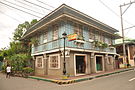
| Virgilio Pansacola Ancestral House | Ancestral house of Virgilio Pansacola, built in 1915. | Quezon | Mauban, Quezon | 14°11′23″N 121°43′50″E / 14.189838°N 121.730629°E |  | ||
| Taino Ancestral House | Ancestral house of the Taino Clan | Quezon | Mauban, Quezon | 14°11′23″N 121°43′50″E / 14.189838°N 121.730629°E | 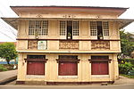 | ||
| Padre Horacio de la Costa Ancestral House | Ancestral house of Horacio de la Costa, S.J., first Filipino Provincial Superior of the Jesuits | Quezon | Mauban, Quezon | 14°11′23″N 121°43′50″E / 14.18973°N 121.730461°E |  | ||
| Talabong-Pansacola Ancestral House | Ancestral house of the Talabong-Pansacola Family | Quezon | Mauban, Quezon | 14°11′23″N 121°43′49″E / 14.189761°N 121.730415°E |  | ||
| Almires-Clemente Ancestral House | Ancestral house of the Almires-Clemente Family, and residence of Regional Trial Court Judge Ramón Clemente. Completed on 15 December 1915. | Quezon | Mauban, Quezon | 14°11′23″N 121°43′49″E / 14.189849°N 121.730286°E |  | ||
| Alquiros-Pastrana Ancestral House | Ancestral house of the Alquiros-Pastrana Family | Quezon | Mauban, Quezon | 14°11′24″N 121°43′50″E / 14.189937°N 121.730637°E |  | ||
| Quintana-Pastrana Ancestral House | Ancestral house of the Quintana-Pastrana Family | Quezon | Mauban, Quezon | 14°11′24″N 121°43′51″E / 14.190059°N 121.730736°E |  | ||
| Garcia-Pastrana Ancestral House | Ancestral house of the García-Pastrana Family | Quezon | Mauban, Quezon | 14°11′25″N 121°43′51″E / 14.19017°N 121.730774°E | 
| ||
| Llamas-Naranjilla Ancestral House | Ancestral house of the Llamas-Naranjilla Family | Quezon | Mauban, Quezon | 14°11′21″N 121°43′49″E / 14.189136°N 121.730179°E |  | ||
| Dejumas-Pastrana Ancestral House | Ancestral house of the Dejumas-Pastrana family. Formerly the Administration Building of Filipinas College | Quezon | Mauban, Quezon | 14°11′21″N 121°43′49″E / 14.189153°N 121.730179°E |  | ||
| Mauban Old Catholic Cemetery | Former municipal graveyard for Roman Catholics | Quezon | Mauban, Quezon | 14°11′32″N 121°43′43″E / 14.192172°N 121.728737°E |  | ||
| Central Quezon Academy | Rosario Building of Central Quezon Academy, established in 1929. | Quezon | Mauban, Quezon | 14°11′29″N 121°43′50″E / 14.191398°N 121.730446°E |  | ||
| Encomienda Ancestral House | Ancestral house of the Encomienda Clan | Quezon | Mauban, Quezon | 14°11′29″N 121°43′49″E / 14.191377°N 121.730385°E |  | ||
| Pelejo Ancestral House | Ancestral house of the Pelejo Clan | Quezon | Mauban, Quezon | Rizal corner Clemente streets | 14°11′27″N 121°43′49″E / 14.190768°N 121.730385°E |  | |
| Gloria Pastrana Ancestral House | Ancestral house of Gloria Pastrana | Quezon | Mauban, Quezon | Rizal Street | 14°11′26″N 121°43′55″E / 14.190638°N 121.732079°E |  | |
| Pomarada Ancestral House | Ancestral house of the Pomarada Clan | Quezon | Mauban, Quezon | Rizal Street | 14°11′26″N 121°43′55″E / 14.190597°N 121.732063°E |  | |
| Bantayan Ancestral House | Ancestral house of the Bantayan Clan | Quezon | Mauban, Quezon | Evangelista corner Gómez streets | 14°11′28″N 121°43′52″E / 14.191076°N 121.731026°E |  | |
| Eleazar-Ysrael Ancestral House | Ancestral house of the Eleazar-Ysrael Family, completed in 1928. | Quezon | Mauban, Quezon | Gómez Street | 14°11′28″N 121°43′51″E / 14.191174°N 121.730759°E |  | |
| Pomarada Ancestral House (Jacinto corner Gómez streets) | Ancestral house of the Pomarada Clan | Quezon | Mauban, Quezon | Jacinto corner Gómez streets | 14°11′29″N 121°43′50″E / 14.191427°N 121.73056°E |  | |
| Balquiedra Ancestral House | Ancestral house of the Balquiedra lan | Quezon | Mauban, Quezon | Gómez corner Jacinto streets | 14°11′29″N 121°43′50″E / 14.191308°N 121.730492°E |  | |
| Inaanuran Ancestral House | Ancestral house of the Inaanuran Clan | Quezon | Mauban, Quezon | Jacinto Street | 14°11′28″N 121°43′49″E / 14.191137°N 121.730362°E |  | |
| Pastores Ancestral House | Ancestral house of the Pastores Clan, built in 1915. | Quezon | Mauban, Quezon | Gómez Street | 14°11′28″N 121°43′51″E / 14.191174°N 121.730759°E |  | |
| Balamban Ancestral House | Ancestral house of the Balamban Clan | Quezon | Mauban, Quezon | Aguinaldo corner Plaridel streets | 14°11′27″N 121°43′47″E / 14.190953°N 121.72982°E |  | |
| Fortunado Ancestral House | Ancestral house of the Fortunado Clan | Quezon | Mauban, Quezon | Aguinaldo Street | 14°11′27″N 121°43′47″E / 14.190806°N 121.729689°E |  | |
| Domingo Moreno Ancestral House | Ancestral house of Domingo Moreno | Quezon | Mauban, Quezon | R. Pansacola corner Aguinaldo streets | 14°11′26″N 121°43′46″E / 14.190491°N 121.729523°E |  | |
| Camposagrado Ancestral House | Ancestral house of the Camposagrado Clan | Quezon | Mauban, Quezon | R. Pansacola corner Bonifacio streets | 14°11′27″N 121°43′46″E / 14.19083°N 121.729309°E |  | |
| Del Banco Ancestral House | Del Banco Ancestral House, dated 23 Nov 1911 on its cement steps. | Quezon | Mauban, Quezon | San Buenaventura Street | 14°11′26″N 121°43′54″E / 14.190509°N 121.731712°E |  | |
| Ysrael Ancestral House | Ancestral house of the Ysrael Clan | Quezon | Mauban, Quezon | San Buenaventura Street | 14°11′26″N 121°43′54″E / 14.190552°N 121.731659°E |  | |
| Sardea Ancestral House | Ancestral house of the Sardea Clan | Quezon | Mauban, Quezon | San Buenaventura Street | 14°11′26″N 121°43′54″E / 14.190553°N 121.731682°E |  | |
| Calvario Ancestral House | Ancestral house of the Calvario Clan | Quezon | Mauban, Quezon | Jocson corner Evangelista streets | 14°11′32″N 121°43′53″E / 14.192169°N 121.731331°E |  | |
| Felipe Escudero, Sr. Ancestral House | Ancestral house of Felipe Escudero, Sr. | Quezon | Mauban, Quezon | Jocson corner General Flores streets | 14°11′32″N 121°43′52″E / 14.19227°N 121.731239°E |  | |
| Villamayor Ancestral House | Ancestral house of the Villamayor Clan | Quezon | Mauban, Quezon | Aguinaldo Street | 14°11′32″N 121°43′50″E / 14.192301°N 121.730454°E |  | |
| Pasamba Ancestral House | Ancestral house of the Pasamba Clan | Quezon | Mauban, Quezon | Bonifacio corner Clemente streets | 14°11′31″N 121°43′48″E / 14.191891°N 121.729965°E |  | |
| Times Theatre of Mauban | Owned by José Rozaldo, operating since the 1950s | Quezon | Mauban, Quezon | 14°11′25″N 121°43′57″E / 14.190317°N 121.732475°E |  | ||
| Mauban Sea Wall | Built in 1935, this structure was declared a Significant Cultural Property by the National Museum of the Philippines. | Quezon | Mauban, Quezon | 14°11′22″N 121°43′59″E / 14.189442°N 121.733025°E |  | ||
| Times Kitchenette and Lodging House | Times Kitchenette and Lodging House, owned by Anita Remolona-Rozaldo | Quezon | Mauban, Quezon | 14°11′25″N 121°43′57″E / 14.190217°N 121.732391°E |  | ||
| Saint Bonaventure Parish Church of Mauban | Parish church of Mauban, dedicated to Saint Bonaventure | Quezon | Mauban, Quezon | 14°11′25″N 121°43′51″E / 14.190397°N 121.730965°E |  |
References[]
- ^ Municipality of Mauban | (DILG)
- ^ "2015 Census of Population, Report No. 3 – Population, Land Area, and Population Density" (PDF). Philippine Statistics Authority. Quezon City, Philippines. August 2016. ISSN 0117-1453. Archived (PDF) from the original on May 25, 2021. Retrieved July 16, 2021.
- ^ https://en-nz.topographic-map.com/maps/i8sg/Mauban/.
- ^ a b Census of Population (2020). "Region IV-A (Calabarzon)". Total Population by Province, City, Municipality and Barangay. PSA. Retrieved 8 July 2021.
- ^ https://psa.gov.ph/sites/default/files/City%20and%20Municipal-level%20Small%20Area%20Poverty%20Estimates_%202009%2C%202012%20and%202015_0.xlsx; publication date: 10 July 2019; publisher: Philippine Statistics Authority.
- ^ "An Act Changing the Name of the Barrio of Tubog in the Municipality of Mauban, Province of Quezon, to San Gabriel". PhilippineLaw.info. Retrieved 2013-01-25.
- ^ "Mauban: Average Temperatures and Rainfall". Meteoblue. Retrieved 27 January 2020.
- ^ Census of Population (2015). "Region IV-A (Calabarzon)". Total Population by Province, City, Municipality and Barangay. PSA. Retrieved 20 June 2016.
- ^ Census of Population and Housing (2010). "Region IV-A (Calabarzon)". Total Population by Province, City, Municipality and Barangay. NSO. Retrieved 29 June 2016.
- ^ Censuses of Population (1903–2007). "Region IV-A (Calabarzon)". Table 1. Population Enumerated in Various Censuses by Province/Highly Urbanized City: 1903 to 2007. NSO.
- ^ "Province of Quezon". Municipality Population Data. Local Water Utilities Administration Research Division. Retrieved 17 December 2016.
- ^ "Poverty incidence (PI):". Philippine Statistics Authority. Retrieved 28 December 2020.
- ^ https://psa.gov.ph/sites/default/files/NSCB_LocalPovertyPhilippines_0.pdf; publication date: 29 November 2005; publisher: Philippine Statistics Authority.
- ^ https://psa.gov.ph/sites/default/files/2003%20SAE%20of%20poverty%20%28Full%20Report%29_1.pdf; publication date: 23 March 2009; publisher: Philippine Statistics Authority.
- ^ https://psa.gov.ph/sites/default/files/2006%20and%202009%20City%20and%20Municipal%20Level%20Poverty%20Estimates_0_1.pdf; publication date: 3 August 2012; publisher: Philippine Statistics Authority.
- ^ https://psa.gov.ph/sites/default/files/2012%20Municipal%20and%20City%20Level%20Poverty%20Estima7tes%20Publication%20%281%29.pdf; publication date: 31 May 2016; publisher: Philippine Statistics Authority.
- ^ https://psa.gov.ph/sites/default/files/City%20and%20Municipal-level%20Small%20Area%20Poverty%20Estimates_%202009%2C%202012%20and%202015_0.xlsx; publication date: 10 July 2019; publisher: Philippine Statistics Authority.
- ^ "Philippine President Estrada Inaugurates Quezon Power Project". InterGen. Archived from the original on 2013-01-26. Retrieved 2012-10-05.
- ^ "Masterlist of Public Schools". Department of Education of the Philippines. Retrieved 2010-02-27.
- ^ "Masterlist of Private Schools". Department of Education of the Philippines. Archived from the original on 2010-04-12. Retrieved 2010-02-27.
- ^ "Mother Perpetua Parochial School (HS)". Municipal Government of Mauban. Archived from the original on 2011-08-20. Retrieved 2010-02-27.
- ^ "The Directory of Higher Education Institutions and Programs as of November 11, 2009" (PDF). Commission on Higher Education, Philippines. Retrieved 2010-02-27.
External links[]
| Wikimedia Commons has media related to Mauban. |
- Mauban Profile at PhilAtlas.com
- Municipality of Mauban Website
- Mauban Tourism Website
- Philippine Standard Geographic Code
- Philippine Census Information
- Local Governance Performance Management System
Places adjacent to Mauban | |
|---|---|
- Populated places established in 1583
- Municipalities of Quezon