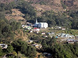
Maubisse
This article may be expanded with text translated from the corresponding article in German. (November 2010) Click [show] for important translation instructions.
|
This article needs additional citations for verification. (April 2017) |
Maubisse | |
|---|---|
 | |
 Maubisse subdistrict | |
 Maubisse Location in East Timor | |
| Coordinates: 8°50′17″S 125°35′50″E / 8.83806°S 125.59722°ECoordinates: 8°50′17″S 125°35′50″E / 8.83806°S 125.59722°E | |
| Country | |
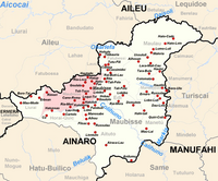
| District | Ainaro District |
| Subdistrict | Maubisse Subdistrict |
| Suco | Maubisse |
| Population | |
| • Total | 6,229 (2,015) |
| Climate | Cwb |

Maubisse (Maubesse, Mau-Bessi, Maobisse, Maubise) is a historic town in the hills 70 km south of Dili, in Ainaro District, East Timor. It is a popular tourist destination and a weekend visiting spot for people from the capital. The suco has 6,229 inhabitants (2015).[1]
Climate[]
Maubisse has a tropical savanna climate (Köppen Aw), bordering on a subtropical highland climate (Köppen Cwb) due to its high elevation.
| Climate data for Maubisse | |||||||||||||
|---|---|---|---|---|---|---|---|---|---|---|---|---|---|
| Month | Jan | Feb | Mar | Apr | May | Jun | Jul | Aug | Sep | Oct | Nov | Dec | Year |
| Average high °C (°F) | 23.9 (75.0) |
23.6 (74.5) |
23.7 (74.7) |
23.7 (74.7) |
23.1 (73.6) |
22.6 (72.7) |
22.6 (72.7) |
23.7 (74.7) |
25.7 (78.3) |
26.8 (80.2) |
26.5 (79.7) |
24.7 (76.5) |
24.2 (75.6) |
| Daily mean °C (°F) | 20.3 (68.5) |
20.1 (68.2) |
20.1 (68.2) |
19.9 (67.8) |
19.5 (67.1) |
18.7 (65.7) |
18.3 (64.9) |
18.5 (65.3) |
20 (68) |
21.2 (70.2) |
21.6 (70.9) |
20.8 (69.4) |
19.9 (67.9) |
| Average low °C (°F) | 18.2 (64.8) |
17.9 (64.2) |
17.7 (63.9) |
17.3 (63.1) |
16.9 (62.4) |
15.9 (60.6) |
15 (59) |
14.3 (57.7) |
15.4 (59.7) |
16.9 (62.4) |
18.1 (64.6) |
18.4 (65.1) |
16.8 (62.3) |
| Average rainfall mm (inches) | 356 (14.0) |
331 (13.0) |
312 (12.3) |
194 (7.6) |
88 (3.5) |
46 (1.8) |
23 (0.9) |
10 (0.4) |
17 (0.7) |
45 (1.8) |
164 (6.5) |
340 (13.4) |
1,926 (75.9) |
| Source: Climate-Data.org[2] | |||||||||||||
References[]
- ^ "2015 Census Publication". Statistic Timor-Leste. Retrieved 2017-04-24.
- ^ "Maubisse climate". Climate-Data.org. Retrieved May 18, 2021.
This East Timor location article is a stub. You can help Wikipedia by . |
Categories:
- Populated places in East Timor
- Ainaro Municipality
- East Timor geography stubs