Mayr Ridge
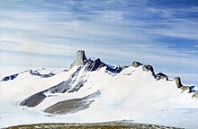
Mayr Ridge (72°11′S 2°22′E / 72.183°S 2.367°ECoordinates: 72°11′S 2°22′E / 72.183°S 2.367°E) is a mountainous ridge including Nupskammen Ridge and Von Essen Mountain, forming the southwestern extremity of the Gjelsvik Mountains in Queen Maud Land, Antarctica. The name "Mayrkette" was applied in the general area by the Third German Antarctic Expedition under Alfred Ritscher, 1938–39, for , the pilot of the flying boat Passat used by the expedition. The correlation of the name with this feature may be arbitrary but is recommended for the sake of international uniformity and historical continuity.[1]
 WikiMiniAtlas
References[]
- ^ "Mayr Ridge". Geographic Names Information System. United States Geological Survey. Retrieved 2013-08-30.
![]() This article incorporates public domain material from the United States Geological Survey document: "Mayr Ridge". (content from the Geographic Names Information System)
This article incorporates public domain material from the United States Geological Survey document: "Mayr Ridge". (content from the Geographic Names Information System)
- Ridges of Queen Maud Land
- Princess Martha Coast
- Princess Martha Coast geography stubs