Mazda Stadium
  | |
 | |
| Full name | Hiroshima Municipal Stadium |
|---|---|
| Location | 2-3-1 Minami-Kaniya, Minami-ku, Hiroshima, Japan |
| Public transit | R Sanyo Main Line at Hiroshima |
| Owner | Hiroshima City |
| Operator | Hiroshima Toyo Carp |
| Capacity | 32,000 300 for wheelchairs Field seats |
| Field size | Left Field - 101 metres (331 ft) Left-Center - 116 metres (381 ft) Center Field - 122 metres (400 ft) Right-Center - 116 metres (381 ft) Right Field - 100 metres (328 ft)  |
| Surface | grass |
| Construction | |
| Opened | April 10, 2009 |
| Architect | |
| Main contractors | Penta-Ocean Construction Co., Ltd. Masuoka Architectural Constructors Inc |
| Tenants | |
| Hiroshima Toyo Carp (NPB) (2009–present) | |
| Wikimedia Commons has media related to Hiroshima Municipal Stadium (2009). |
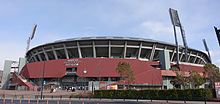
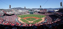
Mazda Stadium Hiroshima (MAZDA Zoom-Zoom スタジアム広島, Matsuda Zūmu-Zūmu Sutajiamu Hiroshima), also called Hiroshima Municipal Stadium (広島市民球場, Hiroshima Shimin Kyūjō), is a baseball stadium in Minami-ku, Hiroshima, Japan. It is used primarily for baseball and is the home of the Hiroshima Toyo Carp of the Japanese Central League. The ballpark has a capacity of 32,000 people and opened on April 10, 2009. It replaced First Hiroshima Municipal Stadium and initially retained the old ballpark's official name. The stadium architecture is considered to be labeled as a retro-classic ballpark.[1]
Naming rights[]
On November 6, 2008, Hiroshima City gave Mazda Motor Corporation naming rights to the stadium. In October of that year, Mazda proposed to call the stadium MAZDA Zoom-Zoom Stadium Hiroshima for the period between April 1, 2009 and March 31, 2014. On December 24, 2008, Mazda entered into a contract with the City of Hiroshima regarding the stadium's name and made official the abbreviated name "Mazda Stadium (マツダスタジアム)". The "Zoom-Zoom" name was a reference to a marketing campaign by Mazda.
References[]
- ^ "Archived copy". Archived from the original on 2012-07-31. Retrieved 2012-08-01.CS1 maint: archived copy as title (link)
External links[]
Coordinates: 34°23′33″N 132°29′02″E / 34.3925°N 132.484°E

This article about a baseball venue in Japan is a stub. You can help Wikipedia by . |
- Baseball venues in Japan
- Sports venues in Hiroshima
- Hiroshima Toyo Carp
- Mazda
- Sports venues completed in 2009
- 2009 establishments in Japan
- Asian baseball venue stubs
- Japanese sports venue stubs