Mehetia
Native name: Meheti'a | |
|---|---|
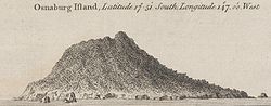 Coastal view of Osnaburg Island, now Mehetia | |
 | |
| Geography | |
| Location | Pacific Ocean |
| Coordinates | 17°52′S 148°04′W / 17.867°S 148.067°WCoordinates: 17°52′S 148°04′W / 17.867°S 148.067°W |
| Archipelago | Society Islands |
| Total islands | 1 |
| Major islands | Mehetia |
| Area | 2.3 km2 (0.89 sq mi) |
| Highest elevation | 435 m (1427 ft) |
| Highest point | Mont Fareura |
| Administration | |
| Overseas collectivity | French Polynesia |
| Administrative subdivision | Windward Islands |
| Commune | Taiarapu-Est |
| Demographics | |
| Population | uninhabited |

| Mont Fareura | |
|---|---|
 NASA Geocover 2000 image | |
| Highest point | |
| Elevation | 435 m (1,427 ft) |
| Prominence | 435 m (1,427 ft) |
| Coordinates | 17°52′S 148°4′W / 17.867°S 148.067°W |
| Geography | |
| Location | Society Islands |
| Geology | |
| Mountain type | Stratovolcano |
| Last eruption | Unknown |
Meheti'a or Me'eti'a is a volcanic island in the Windward Islands, in the east of the Society Islands in French Polynesia. This island is a very young active stratovolcano 110 kilometres (68 mi) east of the Taiarapu Peninsula of Tahiti. It belongs to the Teahiti'a-Mehetia hotspot.
The island has an area of 2.3 square kilometres (0.89 sq mi) and its highest point is 435 metres (1,427 ft). Meheti'a's well-defined volcanic crater contains a very active hot point. In 1981 the island was the centre of earthquakes.
History[]
Tahitian oral tradition holds that navigators stopped at Mehiti'a, which was regarded as sacred, on their long voyage to New Zealand.[1] This oral history correlates with geological evidence found in southern New Zealand which can be traced back to Mehiti'a.[2]
The early Polynesian voyagers commonly gave Polynesian ancestral names and symbolism to new places.[3] The high point of Mehetia is Mount Hiurai (Hi’ura’i/Hikurangi) [4] The name Hikurangi in Aotearoa / New Zealand probably came from Mehetia [5] and the name Hi’ura’i probably has its origin in Si'ulagi (Si'ulangi) in Ta'u, Samoa [6]
The first European sighting was by the Spanish expedition of Pedro Fernández de Quirós on 9 February 1606, that charted it as Decena (ten in Spanish).[7] Later on it was sighted by Samuel Wallis in HMS Dolphin 1767 and Louis Antoine de Bougainville in 1768.[8] It was also sighted by Spanish navigator Domingo de Boenechea on November 6, 1772, on ship Aguila.[8]: 241 He named this island San Cristóbal.
Administration[]
Meheti'a is administratively part of the commune (municipality) of Taiarapu-Est and of its easternmost commune associée Tautira. The island is uninhabited and does not have much vegetation but has a small coral reef on the underwater slopes.
See also[]
- List of volcanoes in French Polynesia
- List of islands
- Desert island
References[]
- ^ "Scoria blocks reinforces early Polynesian links to Southland". The Southland Times. Stuff. 3 April 2019. Retrieved 15 April 2019.
- ^ "Rock find in New Zealand rewrites story of Polynesian voyage". NZ Herald. 2019-04-06. ISSN 1170-0777. Retrieved 2020-08-24.
- ^ "Ancestral Naming of Places",
- ^ "Mount Hiurai (Hi’ura’i/Hikurangi)"
- ^ "Mount Hiurai (Hi’ura’i/Hikurangi)"
- ^ "Si'ulagi(Si'ulangi)in Ta'u"
- ^ Corney, Bolton Granvill The quest and occupation of Tahiti by emissaries of Spain during the years 1772-1776, London, 1913, Vol I, p.XXX
- ^ a b Salmond, Anne (2010). Aphrodite's Island. Berkeley: University of California Press. pp. 39, 45, 93. ISBN 9780520261143.
External links[]
| |||
This French Polynesia-related geography article is a stub. You can help Wikipedia by . |
- French Polynesia geography stubs
- Volcanoes of French Polynesia
- Stratovolcanoes of France
- Active volcanoes
- Islands of the Society Islands
- Uninhabited islands of French Polynesia