Merir
This article needs additional citations for verification. (November 2020) |
Merir or Melieli is a small outlying island of the Palau group, in the western Pacific Ocean. The island measures 0.90 km2 and is uninhabited. There is an abandoned village in the north-west of the island which previously hosted a radio station. It is very long and narrow, stretching approximately 2.4 kilometers from north to south, but only approximately 667 meters at its widest.
The island itself is covered with trees but it is surrounded by a beach around which is a lagoon. Outside this, the whole is surrounded by a coral reef and the open ocean.
Together with the islands of Sonsorol and Fanna, which are 110 km to the north-west, and the island of Pulo Anna 50 km away, Merir forms the state of Sonsorol in the republic of Palau.
The first recorded sighting of Merir by the Europeans was by the Spanish missionary expedition commanded by Sargento Mayor Francisco Padilla on board of the patache Santísima Trinidad in November 1710.[1]
Gallery[]
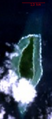
Satellite view of the Island of Merir
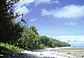
Luxuriant vegetation and beach scene in western Merir

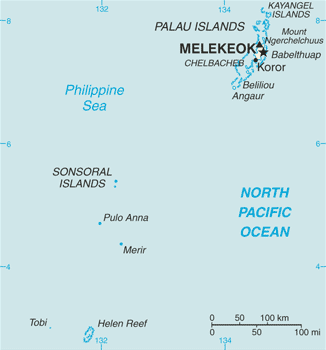
Map including Merir (DMA, 1991)


References[]
- ^ Rienzi, M.L. Historia de la Oceanía, o quinta parte del mundo, Barcelona, 1845-1846, vol.2, p.78
External links[]
| Wikimedia Commons has media related to Merir. |
Coordinates: 4°19′N 132°19′E / 4.317°N 132.317°E

This Palau location article is a stub. You can help Wikipedia by . |
- Islands of Palau
- Sonsorol
- Palau geography stubs