Merki District
Merki | |
|---|---|
District | |
| Меркі ауданы | |
 Coat of arms | |
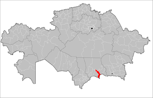 Location of Merki District in Kazakhstan | |
| Coordinates: 42°52′48″N 73°10′48″E / 42.88000°N 73.18000°E | |
| Country | |
| Region | Jambyl Region |
| Administrative center | Merki |
| Area | |
| • Total | 7,100 km2 (2,700 sq mi) |
| Population (2013) | |
| • Total | 81,712 |
| Time zone | UTC+6 (East) |

Merki (Kazakh: Меркі ауданы, Merki aýdany) is a district of Jambyl Region in south-eastern Kazakhstan. The administrative center of the district is the selo of Merki.[1]
References[]
- ^ "www.geonames.de Subdivisions of Kazakhstan in local languages". Archived from the original on 2018-10-06. Retrieved 2008-05-07.
Capital: Taraz | ||
| Districts | 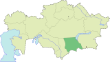 | |
| Major cities | ||
Coordinates: 42°52′48″N 73°10′48″E / 42.88000°N 73.18000°E
This Kazakhstan location article is a stub. You can help Wikipedia by . |
Categories:
- Districts of Kazakhstan
- Jambyl Region
- Kazakhstan geography stubs