Merrion Road
 | |||
 | |||
| Native name | Bóthar Mhuirfean (Irish) | ||
|---|---|---|---|
| Namesake | Merrion Castle, seat of the Viscounts FitzWilliam | ||
| Length | 2.9 km (1.8 mi) | ||
| Width | 24 metres (79 ft) | ||
| Location | Dublin, Ireland | ||
| Postal code | D04 | ||
| Coordinates | 53°19′16″N 6°12′59″W / 53.321005°N 6.216309°WCoordinates: 53°19′16″N 6°12′59″W / 53.321005°N 6.216309°W | ||
| north end | Ball's Bridge | ||
| south end | Rock Road, Trimleston Avenue | ||
| Other | |||
| Known for | St. Vincent's University Hospital, Wanderers F.C., Royal Dublin Society, embassies | ||

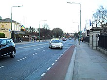
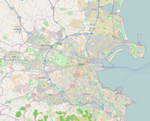
Merrion Road is a major road, part of the R118, in Dublin 4.
It joins the Pembroke Road section of the R118 at Herbert Park and runs south-east to Merrion, where it meets the Rock Road, Booterstown.
At Merrion Gates it meets Strand Road (R131) just after the latter crosses the DART line.
There are a number of well-known buildings along Merrion Road. These include the Royal Dublin Society (RDS), the British Embassy, the Catholic church Our Lady Queen Of Peace, the Merrion Shopping Centre, some well-known hotels and part of the Embassy Belt, Ballsbridge. Wanderers F.C. (rugby union) and St. Vincent's University Hospital are also located on the road.
See also[]
This Irish road or road transport-related article is a stub. You can help Wikipedia by . |
Categories:
- Streets in Dublin (city)
- Merrion, Dublin
- Ireland road stubs