Mersing River
This article needs additional citations for verification. (May 2008) |
| Mersing River | |
|---|---|
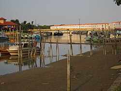 Mersing River at Mersing town | |
| Native name | Sungai Mersing (Malay) |
| Location | |
| Country | Malaysia |
| Physical characteristics | |
| Mouth | |
• location | South China Sea |
• coordinates | 2°26′9″N 103°50′25″E / 2.43583°N 103.84028°ECoordinates: 2°26′9″N 103°50′25″E / 2.43583°N 103.84028°E |
• elevation | 0 m (0 ft) |
| Basin size | 270 km2 (100 sq mi) |

The Mersing River (Malay: Sungai Mersing) is a river in Johor state Malaysia. It flows from south to north with a catchment of 270 km².[1] The River mouth is in Mersing and goes to the South China Sea.
References[]
- ^ "Archived copy" (PDF). Archived from the original (PDF) on 2011-07-21. Retrieved 2011-04-09.
{{cite web}}: CS1 maint: archived copy as title (link)
| Wikimedia Commons has media related to Mersing River. |
This Johor location article is a stub. You can help Wikipedia by . |
Categories:
- Mersing District
- Rivers of Johor
- Johor geography stubs
- Malaysia river stubs