Mescal Range
| Mescal Range | |
|---|---|
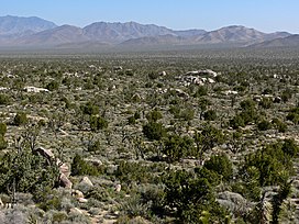 Viewed from Cima Dome, the Mescal Range is the ridge on the horizon slightly left of center | |
| Highest point | |
| Elevation | 1,981 m (6,499 ft) |
| Coordinates | 35°25.908′N 115°32.780′W / 35.431800°N 115.546333°W |
| Geography | |
 location of Mescal Range in California[1] | |
| Country | United States |
| State | California |
| District | San Bernardino County |
| Range coordinates | 35°26′27.938″N 115°33′7.991″W / 35.44109389°N 115.55221972°WCoordinates: 35°26′27.938″N 115°33′7.991″W / 35.44109389°N 115.55221972°W |
| Topo map | USGS Mescal Range |

The Mescal Range is a small mountain range in the eastern Mojave Desert in California about 12 miles from the Nevada state line.
The range lies just to the south of Interstate 15 near Mountain Pass. The Clark Mountain Range lies to the north. It lies northwest of the Ivanpah Mountains across Paiute Valley. To the west is the broad Shadow Valley. The mountains are approximately six miles long. Mines in the range include the Mollusk, Blue Buzzard and Iron Horse mines along the eastern end.[2]
References[]
- ^ "Mescal Range". Geographic Names Information System. United States Geological Survey. Retrieved 2009-05-04.
- ^ Ivanpah, California—Nevada, 30x60 Minute Topographic Quadrangle, USGS, 1985
- Allan, Stuart (2005). California Road and Recreation Atlas. . p. 97. ISBN 0-929591-80-1.
This San Bernardino County, California–related article is a stub. You can help Wikipedia by . |
Categories:
- Mountain ranges of Southern California
- Mountain ranges of the Mojave Desert
- Mountain ranges of San Bernardino County, California
- San Bernardino County, California geography stubs