Meusnier Point
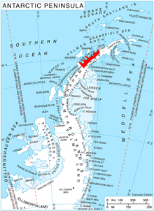
Meusnier Point (64°33′S 61°38′W / 64.550°S 61.633°WCoordinates: 64°33′S 61°38′W / 64.550°S 61.633°W) is a point within Charlotte Bay, forming the western extremity of Eurydice Peninsula, and lying 4 nautical miles (7 km) southeast of Portal Point on the west coast of Graham Land, Antarctica. It was charted by the Belgian Antarctic Expedition under Gerlache, 1897–99, and was named by the UK Antarctic Place-Names Committee in 1960 for French military engineer Jean B.M. Meusnier, the prophetic designer, in 1785, of the first dirigible airship.[1]
 WikiMiniAtlas
References[]
- ^ "Meusnier Point". Geographic Names Information System. United States Geological Survey. Retrieved 2013-09-23.
![]() This article incorporates public domain material from the United States Geological Survey document: "Meusnier Point". (content from the Geographic Names Information System)
This article incorporates public domain material from the United States Geological Survey document: "Meusnier Point". (content from the Geographic Names Information System)
This Danco Coast location article is a stub. You can help Wikipedia by . |
- Headlands of Graham Land
- Danco Coast
- Danco Coast geography stubs