Międzylesie
This article needs additional citations for verification. (January 2021) |
Międzylesie | |
|---|---|
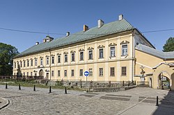 Castle | |
 Flag  Coat of arms | |
 Międzylesie | |
| Coordinates: 50°8′58″N 16°39′59″E / 50.14944°N 16.66639°ECoordinates: 50°8′58″N 16°39′59″E / 50.14944°N 16.66639°E | |
| Country | |
| Voivodeship | Lower Silesian |
| County | Kłodzko |
| Gmina | Międzylesie |
| Area | |
| • Total | 14.37 km2 (5.55 sq mi) |
| Population (2019-06-30[1]) | |
| • Total | 2,575 |
| • Density | 180/km2 (460/sq mi) |
| Website | http://www.miedzylesie.pl |

Międzylesie [mʲɛnd͡zɨˈlɛɕɛ] (German: Mittelwalde) is a town in Kłodzko County, Lower Silesian Voivodeship, in south-western Poland. It is the seat of the administrative district (gmina) called Gmina Międzylesie, close to the Czech border. It lies approximately 33 kilometres (21 mi) south of Kłodzko, and 112 kilometres (70 mi) south of the regional capital Wrocław.
As at 2019, the town has a population of 2,575.
See also[]
References[]
- ^ "Population. Size and structure and vital statistics in Poland by territorial division in 2019. As of 30th June". stat.gov.pl. Statistics Poland. 2019-10-15. Retrieved 2020-02-14.
| hide | ||
|---|---|---|
| Town and seat |  | |
| Villages | ||
| show Authority control |
|---|
This Kłodzko County location article is a stub. You can help Wikipedia by . |
Categories:
- Cities and towns in Lower Silesian Voivodeship
- Kłodzko County
- Cities in Silesia
- Kłodzko County geography stubs