Michigamme River
| Michigamme River | |
|---|---|
 | |
| Location | |
| Country | United States |
| State | Michigan |
| Physical characteristics | |
| Mouth | |
• coordinates | 45°57′12″N 88°11′43″W / 45.9533°N 88.1953°W |
| Length | 67.0 miles (107.8 km) |

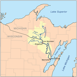
The Michigamme River is a 67.0-mile-long (107.8 km)[1] tributary of the Menominee River on the Upper Peninsula of Michigan in the United States. Via the Menominee River, its water flows to Lake Michigan.
The Michigamme River flows from Lake Michigamme in Marquette County, through Dickinson County, , Peavy Pond and Michigamme Lake in Iron County to its confluence with the Brule River, forming the Menominee River. The confluence can be viewed from the dam on Michigamme Lake. In addition, there is a spillway from the Paint River which flows into Peavy Pond.
See also[]
References[]
- ^ U.S. Geological Survey. National Hydrography Dataset high-resolution flowline data. The National Map Archived 2012-04-05 at WebCite, accessed December 19, 2011
This Marquette County, Michigan location article is a stub. You can help Wikipedia by . |
This Dickinson County, Michigan location article is a stub. You can help Wikipedia by . |
This Iron County, Michigan location article is a stub. You can help Wikipedia by . |
- Rivers of Michigan
- Rivers of Marquette County, Michigan
- Rivers of Dickinson County, Michigan
- Rivers of Iron County, Michigan
- Tributaries of Lake Michigan
- Upper Peninsula, Michigan geography stubs
- Michigan river stubs