Milbanke Sound
| Milbanke Sound | |
|---|---|
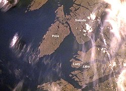 Satellite image of Milbanke Sound | |
 Milbanke Sound Location in British Columbia | |
| Location | British Columbia, Canada |
| Coordinates | 52°19′N 128°33′W / 52.317°N 128.550°WCoordinates: 52°19′N 128°33′W / 52.317°N 128.550°W |
| Type | Sound |
| Ocean/sea sources | Pacific Ocean |

Milbanke Sound is a sound on the coast of the Canadian province of British Columbia.[1]
Geography[]
Milbanke Sound extends east from Queen Charlotte Sound, with Price Island on the west, Swindle Island on the north, and the Bardswell Group of islands on the south.[2] Milbanke Sound is one of the open sea portions of the Inside Passage, with Seaforth Channel joining from the east and Finlayson Channel from the north.[3][4] Mathieson Channel also connects to Milbanke Sound from the north, and leads to Fiordland Conservancy.
On the islands surrounding the sound is a group of five volcanos called the Milbanke Sound cones.[5]
History[]
The Heiltsuk peoples traditionally occupied the land around Milbanke Sound.[6][7][8]
In late June, 1788, the British fur trader Charles Duncan, captain of Princess Royal, entered Milbanke Sound, which was then uncharted waters. He spent a few days trading with the Heiltsuk.[9] He named the sound after Vice Admiral Mark Milbanke.[10] Explorer George Vancouver sailed through the sound a few years later.[8][11] In 1805, a trading ship from Boston, the Atahualpa, was attacked by a group of Tlingit; the captain and some of the crew were killed.[12][13]
In 1833 the Hudson's Bay Company established Fort McLoughlin in the Milbanke Sound area.[14][15] William Fraser Tolmie was stationed there in 1833-1834. Tolmie wrote about the fur trade in the area, saying that it was conducted with the Coast Tsimshians and Heiltsuks, using a pidgin jargon composed of the Kaigani and Tshatshinni dialects of Haida and English. Chinook Jargon, commonly used elsewhere, was not widely known in Milbanke Sound at the time.[16] The fort operated for about ten years, and then was abandoned; the company later opened a small store at the same location.[17]
To improve the safety of the developing travel and shipping lanes, a lighthouse was built in 1898 at Robb Point on Ivory Island.[18]
In recent times archaeological investigations have been carried out in the Milbanke Sound area.[19][20]
Economy[]
The sound is popular with sports fishing enthusiasts.[21]
See also[]
References[]
- ^ "Milbanke Sound". Canadian Geographical Names. Natural Resources Canada. Retrieved March 19, 2018.
- ^ British Columbia Pilot ...: The coast of British Columbia from Cape Caution to Portland Inlet, including the Queen Charlotte Islands and Dixon Entrance. U.S. Government Printing Office. 1930. p. 103.
- ^ Great Britain. Hydrographic Department (1935). The British Columbia Pilot: Comp. from Admiralty Surveys. p. v.
- ^ United States. Hydrographic Office (1952). Sailing Directions for British Columbia: The coast of British Columbia from Cape Caution to Portland Inlet, including the Queen Chalotte Island and Dixon Entrance. U.S. Government Printing Office. pp. 62–65.
- ^ Charles A. Wood; Jurgen Kienle (ed) (27 November 1992). Volcanoes of North America: United States and Canada. Cambridge University Press. p. 130. ISBN 978-0-521-43811-7.CS1 maint: extra text: authors list (link)
- ^ "Heiltsuk (Bella Bella)", The Canadian Encyclopedia
- ^ Historical Notes on the Bella Bella Heiltsuk Archived 2009-04-09 at the Wayback Machine, The Heiltsuk Cultural Education Centre
- ^ Jump up to: a b W. Kaye Lamb (15 May 2017). The Voyage of George Vancouver, 1791–1795: Volumes I–IV. Taylor & Francis. p. 1062. ISBN 978-1-317-01233-7.
- ^ Galois, Robert (2004). Voyage to the Northwest Side of America: The Journals of James Colnett, 1786-89. University of British Columbia (UBC) Press. pp. 9, 11, 17, 62, 99, 263–264, 329. ISBN 978-0-7748-0855-2. online at Google Books
- ^ V., Akrigg, G. P. (1997). British Columbia place names. Akrigg, Helen B. (3rd ed.). Victoria, BC: UBC Press. ISBN 0774806362. OCLC 41086359.
- ^ Barry Gough (15 June 2015). Juan de Fuca's Strait: Voyages in the Waterway of Forgotten Dreams. Harbour Publishing. p. 90. ISBN 978-1-55017-653-7.
- ^ Mary Malloy (1998). "Boston Men" on the Northwest Coast: The American Maritime Fur Trade 1788-1844. Limestone Press. p. 74. ISBN 978-1-895901-18-4.
- ^ Owen Matthews (12 November 2013). Glorious Misadventures: Nikolai Rezanov and the Dream of a Russian America. Bloomsbury Publishing. pp. 285–. ISBN 978-1-62040-241-2.
- ^ Jan Peterson (2002). Black Diamond City: Nanaimo, the Victorian Era. Heritage House Publishing Co. p. 25. ISBN 978-1-894384-51-3.
- ^ "Our History: The Scots who helped build B.C.". Times Colonist, Jan Peterson / May 16, 2014
- ^ Wurm, Stephen A.; Peter Mühlhäusler; Darrell T. Tryon (1996). Atlas of Languages of Intercultural Communication in the Pacific, Asia, and the Americas. Mouton de Gruyter. p. 1198. ISBN 3-11-013417-9. online at Google Books
- ^ Barry Pritzker (1998). Native Americans: An Encyclopedia of History, Culture, and Peoples. ABC-CLIO. p. 230. ISBN 978-0-87436-836-9.
- ^ Jim Gibbs (January 1986). Lighthouses of the Pacific. Schiffer Pub. p. 245. ISBN 978-0-88740-054-4.
- ^ Archaeological Investigations in the Hecate Strait-Milbanke Sound Area, Archaeological Survey of Canada
- ^ "Angling at B.C.'s Top Fishing Resorts". Vancouver Sun, David Y. Wei and Suzanne L. Clouthier , May 16, 2016
- ^ "Great Fishing on the Wild Central Coast of British Columbia". Sports Fishing Magazine, Doug Olander. September 15, 2014
External links[]
| Wikimedia Commons has media related to Milbanke Sound. |
- Sounds of British Columbia
- Central Coast of British Columbia
- Heiltsuk
- Range 3 Coast Land District