Milk River (Alberta–Montana)
| Milk River | |
|---|---|
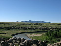 The Milk River in Writing-on-Stone Provincial Park | |
 The Milk River shown highlighted | |
| Etymology | Named by the Lewis and Clark Expedition for its milky color |
| Location | |
| Countries | United States and Canada |
| State | Montana |
| Province | Alberta |
| Physical characteristics | |
| Source | Confluence of South and Middle Forks |
| • location | Glacier County, Montana |
| • coordinates | 48°51′20″N 113°01′10″W / 48.85556°N 113.01944°W[1] |
| • elevation | 4,403 ft (1,342 m) |
| Mouth | Missouri River |
• location | Valley County, Montana |
• coordinates | 48°03′26″N 106°19′07″W / 48.05722°N 106.31861°WCoordinates: 48°03′26″N 106°19′07″W / 48.05722°N 106.31861°W[1] |
• elevation | 2,024 ft (617 m) |
| Length | 729 mi (1,173 km) |
| Basin size | 23,800 sq mi (62,000 km2)[2] |
| Discharge | |
| • location | Nashua, Montana, 22.7 mi (36.5 km) from the mouth[3] |
| • average | 618 cu ft/s (17.5 m3/s)[4] |
| • minimum | 0 cu ft/s (0 m3/s) |
| • maximum | 45,300 cu ft/s (1,280 m3/s) |

The Milk River is a tributary of the Missouri River, 729 mi (1,173 km) long, in the U.S. state of Montana and the Canadian province of Alberta. Rising in the Rocky Mountains, the river drains a sparsely populated, semi-arid watershed of 23,800 sq mi (61,642 km2), ending just east of Fort Peck, Montana.
Geography[]
It is formed in Glacier County in northwestern Montana, 21 miles (34 km) north of Browning, Montana, by the confluence of its South and Middle forks. The 30-mile (48 km) long South Fork and 20-mile (32 km) long Middle Fork both rise in the Rocky Mountains just east of Glacier National Park, in the Blackfeet Indian Reservation.[citation needed] Much of the water in the North Fork is diverted from the St. Mary River through a canal and inverted siphon.[5]
The main stream flows east-northeast into southern Alberta, where it is joined by the , from there It flows past the town of Milk River and Writing-on-Stone Provincial Park, then turns southeast into Montana, running east along the north side of the Sweetgrass Hills, turning south, passing through the Fresno Dam, then east past Havre and along the north side of the Fort Belknap Indian Reservation. Near Malta, it turns north, then southeast, flowing past Glasgow and joining the Missouri in Valley County, Montana, 5 miles (8 km) downstream from Fort Peck Dam.[citation needed]
The watershed of the river extends into the Canadian provinces of Alberta and Saskatchewan and the US state of Montana. The watershed of the river covers an area of 61,642 km2 (23,800 sq mi). Of this 6,500 km2 (2,510 sq mi) lies in Alberta, 14,942 km2 (5,769 sq mi) in Saskatchewan and the remaining in Montana.[6] The area in Alberta and Saskatchewan is one of the only parts of the Mississippi River watershed that extends into Canada.
| River | Location | Discharge |
|---|---|---|
| North Fork Milk River | US-Canada Border | 99 cu ft/s (2.8 m3/s)[7] |
| South Fork Milk River | near Browning | 98 cu ft/s (2.8 m3/s)[8] |
| Milk River | Nashua | 618 cu ft/s (17.5 m3/s) |
History[]
The Milk River was given its name by Captain Meriwether Lewis,[9] of the Lewis and Clark Expedition, who described the river in his journal:
- "the water of this river possesses a peculiar whiteness, being about the colour of a cup of tea with the admixture of a tablespoonfull of milk. from the colour of its water we called it Milk river."
This appearance results from clays and silts suspended in its waters. These fine-grained sediments result from the erosion of soft clay-rich rocks along the Milk River basin in southern Alberta, such as the Foremost, Oldman and Dinosaur Park formations.[10]

At the time of Lewis's exploration, the Milk River drainage was legally part of the United States as a component of the Louisiana Purchase. However, in 1818 U.S. negotiators swapped a portion of the Milk River watershed that lay north of 49° north latitude, receiving in exchange for a parcel of Red River of the North drainage that had previously been part of British North America.[citation needed]
In 1908, the waters of the Milk River were the subject of a United States Supreme Court case clarifying the water rights of American Indian reservations. The case is known as Winters v. United States.
See also[]
- Montana Stream Access Law
- List of longest rivers of Canada
- List of longest rivers of the United States (by main stem)
- List of rivers of Montana
- List of rivers of Alberta
References[]
- ^ Jump up to: a b "Milk River". Geographic Names Information System. United States Geological Survey. 1980-04-04. Retrieved 2011-10-28.
- ^ "Overview of the Milk River Watershed". Milk River Watershed Council Canada. Archived from the original on July 29, 2013.
- ^ "USGS Gage #06174500 on the Milk River at Nashua, MT" (PDF). National Water Information System. U.S. Geological Survey. 2010. Retrieved 2011-10-28.
- ^ "USGS Gage #06174500 on the Milk River at Nashua, MT" (PDF). National Water Information System. U.S. Geological Survey. 2010. Retrieved 2011-10-28.
- ^ "Milk River Project". . Retrieved 2017-10-16.
- ^ "Overview of the Milk River Watershedt". U.S. Bureau of Reclamation. 2011-05-11. Retrieved 2011-10-28.
- ^ "USGS Surface Water data for Montana: USGS Surface-Water Annual Statistics".
- ^ "USGS Surface Water data for Montana: USGS Surface-Water Annual Statistics".
- ^ "The Journals of the Lewis and Clark Expedition". University of Nebraska. Retrieved 2016-12-04.
- ^ Prior, G. J., Hathaway, B., Glombick, P.M., Pana, D.I., Banks, C.J., Hay, D.C., Schneider, C.L., Grobe, M., Elgr, R., and Weiss, J.A. (2013). "Bedrock Geology of Alberta. Alberta Geological Survey, Map 600". Archived from the original on 2013-09-25. Retrieved 2013-08-13.CS1 maint: multiple names: authors list (link)
External links[]
| Wikimedia Commons has media related to Milk River (Alberta–Montana). |

| show Authority control |
|---|
- Lewis and Clark Expedition
- Rivers of Alberta
- Rivers of Montana
- Tributaries of the Missouri River
- International rivers of North America
- Rivers of Glacier County, Montana