Minamikarasuyama
Minamikarasuyama
南烏山 | |
|---|---|
District | |
 | |
 Minamikarasuyama | |
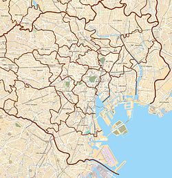
| Coordinates: 35°40′5.77″N 139°36′4.4″E / 35.6682694°N 139.601222°ECoordinates: 35°40′5.77″N 139°36′4.4″E / 35.6682694°N 139.601222°E | |
| Country | Japan |
| City | Tokyo |
| Ward | Setagaya |
| Population (September 1, 2019)[1] | |
| • Total | 23,445 |
| Time zone | UTC+9 (JST) |
| Postal code | 156-0062[2] |
| Area code | 03 |

Minamikarasuyama (南烏山) is a district of Setagaya, Tokyo, Japan.
Geography[]
Minamikarasuyama borders Kasuya and Kamisoshigaya to the south, Kyūden to the west, Kitano in Mitaka, Kitakarasuyama to the north, Muri in Suginami, Kugayama and Hachimanyama to the east.
The southern part originated from a village along the Kōshū Kaidō, and the northern part was mainly triggered by the following "Karasuyama Temple Town". For this reason, the northern part has different characteristics from the area around Chitose-Karasuyama Station, such as some facilities called "Kugayama" and "Mitaka".
References[]
- ^ "世田谷区の町丁別人口と世帯数". 世田谷区. 2019-09-03. Retrieved 2019-09-29.
- ^ "郵便番号". 日本郵便. Retrieved 2019-08-30.
| hide | ||||||||||||
|---|---|---|---|---|---|---|---|---|---|---|---|---|
| Districts |
| 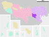 | ||||||||||
| Education | ||||||||||||
| Major stations |
| |||||||||||
Categories:
- Districts of Setagaya