Mindat District
Mindat District |
|---|
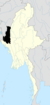
Mindat District (Burmese: မင်းတပ်ခရိုင်) is a district in the Chin State of Myanmar. It consists of two townships and 840 villages.

History[]
In 1948, after the formation of the constitution for the Union of Burma, Pakokku province was created with two districts - Pakokku District and Mindat District. They comprised a total of 11 townships - Pakokku (capital city), Mindat, Yesagyo, Pauk, Seikphyu, Myaing, Gangaw, Htilin, Saw, Kanpetlet, and Matupi.
On March 2nd, 1962 the military led by General Ne Win took control of Burma through a coup d'état, which put the government under the direct control of the military. A new constitution of the Socialist Republic of the Union of Burma was established on May 4th, 1974.
Pakokku province was then broken up in a fashion, whereby Pakokku District was added to the Magway Division, and Mindat District was added to Chin State.[1][2][3][4][5]
Townships[]
Mindat District contains the townships of Mindat and Kanpetlet.
References[]
- ^ "မတူပီမြို့နှင့် ရှစ်မိုင်ခန့်အကွာတွင် ခရိုင်ရုံး တည်ဆောက်ရန် လျာထားမှုကို သဘောမတူဘဲ မြို့၏ စည်ပင်သာယာ နယ်နိမိတ်အတွင်း၌သာ ဆောက်လုပ်ရန် လိုလားကြောင်း ဒေသခံများက ရန်ကုန်မြို့၌ သတင်းစာ ရှင်းလင်း". အီလဲဗင်း သတင်းစာ.
- ^ "ပလက်ဝမြို့နယ်အား မတူပီခရိုင်အတွင်း ထည့်သွင်းမဖွဲ့စည်းရန် ချင်းပါတီတောင်းဆို". ဒီဗွီဘီ].
- ^ "မတူပီခရိုင်ဖွဲ့စည်းရေး မြေနေရာအခက်အခဲကြောင့်ကြန့်ကြာ".
- ^ "တိုင်းဒေသကြီးနှင့် ပြည်နယ်များရှိ ခရိုင်၊ မြို့နယ်၊ မြို့၊ ရပ်ကွက်၊ ကျေးရွာအုပ်စုနှင့် ကျေးရွာဦးရေ စာရင်းချုပ်". .
- ^ "တိုင်းဒေသကြီးနှင့် ပြည်နယ်များရှိ ခရိုင်၊ မြို့နယ်၊ မြို့၊ ရပ်ကွက်၊ ကျေးရွာအုပ်စုနှင့် ကျေးရွာဦ��ရေ စာရင်းချုပ်(၃၁.၃.၂၀၁၆)". .
Capital: Hakha | ||
| Falam District |
|  |
| Hakha District |
| |
| Matupi District | ||
| Mindat District | ||
| Cities and towns | ||
Coordinates: 21°28′N 93°24′E / 21.467°N 93.400°E

This Myanmar location article is a stub. You can help Wikipedia by . |
- Districts of Myanmar
- Chin State
- Myanmar geography stubs