Miradero, Cabo Rojo, Puerto Rico
Miradero | |
|---|---|
Barrio | |
 Joyuda in Miradero | |
 Flag  Seal | |
 Location of Miradero within the municipality of Cabo Rojo shown in red | |
 Miradero Location of Puerto Rico | |
| Coordinates: 18°05′19″N 67°10′38″W / 18.088587°N 67.177172°WCoordinates: 18°05′19″N 67°10′38″W / 18.088587°N 67.177172°W[1] | |
| Commonwealth | |
| Municipality | |
| Area | |
| • Total | 9.66 sq mi (25.0 km2) |
| • Land | 7.70 sq mi (19.9 km2) |
| • Water | 1.96 sq mi (5.1 km2) |
| Elevation | 49 ft (15 m) |
| Population (2010) | |
| • Total | 15,521 |
| • Density | 2,013.1/sq mi (777.3/km2) |
| Source: 2010 Census | |
| Time zone | UTC−4 (AST) |
| ZIP code | 00623 |
Miradero is a barrio in the municipality of Cabo Rojo, Puerto Rico. Its population in 2010 was 15,521.[3][4][5] Joyuda, a small fishing village on Cabo Rojos' gastronomic route, is in Miradero.
Features[]
There is a square called Plaza del Pescador in Miradero which happens to be the venue for the annual Festival del pescao (the festival of the fish).[6]
Joyuda, a fishing village in Miradero is known for its many seafood restaurants along Puerto Rico Highway 102, a coastal road.[7] Joyuda was the most impacted area of Cabo Rojo, when Hurricane María hit Puerto Rico on September 20, 2017.[8]
The Ana G. Méndez University has a campus in Miradero.
History[]
Puerto Rico was ceded by Spain in the aftermath of the Spanish–American War under the terms of the Treaty of Paris of 1898 and became an unincorporated territory of the United States. In 1899, the United States Department of War conducted a census of Puerto Rico finding that the population of Miradero barrio was 2,011.[9]
| Historical population | |||
|---|---|---|---|
| Census | Pop. | %± | |
| 1900 | 2,011 | — | |
| 1910 | 2,093 | 4.1% | |
| 1920 | 2,257 | 7.8% | |
| 1930 | 2,599 | 15.2% | |
| 1940 | 2,843 | 9.4% | |
| 1950 | 4,156 | 46.2% | |
| 1980 | 8,799 | — | |
| 1990 | 10,757 | 22.3% | |
| 2000 | 14,358 | 33.5% | |
| 2010 | 15,521 | 8.1% | |
| U.S. Decennial Census[10] 1899 (shown as 1900)[11] 1910-1930[12] 1930-1950[13] 1980-2000[14] 2010[15] | |||
Gallery[]
Places in Miradero:
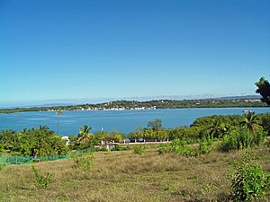
Puerto Real Bay in Miradero

La Playita in Puerto Real

Plaza del Pescador
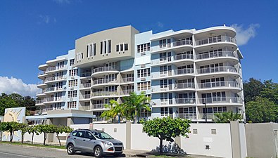
Building in Joyuda
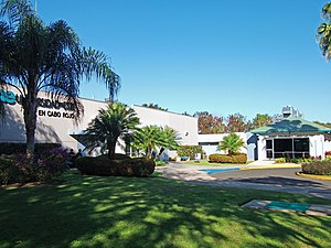
The Ana G. Méndez University, Cabo Rojo campus


See also[]
References[]
- ^ a b "US Gazetteer 2019". US Census. US Government.
- ^ U.S. Geological Survey Geographic Names Information System: Miradero barrio
- ^ Picó, Rafael; Buitrago de Santiago, Zayda; Berrios, Hector H. Nueva geografía de Puerto Rico: física, económica, y social, por Rafael Picó. Con la colaboración de Zayda Buitrago de Santiago y Héctor H. Berrios. San Juan Editorial Universitaria, Universidad de Puerto Rico,1969.
- ^ Gwillim Law (20 May 2015). Administrative Subdivisions of Countries: A Comprehensive World Reference, 1900 through 1998. McFarland. p. 300. ISBN 978-1-4766-0447-3. Retrieved 25 December 2018.
- ^ Puerto Rico 2010: population and housing unit counts.pdf (PDF). U.S. Dept. of Commerce, Economics and Statistics Administration, U.S. Census Bureau. 2010.
- ^ Caban, Sara Marrero (July 9, 2019). "Cabo Rojo celebrará la edición 49 de la Fiesta del Pescao".
- ^ "Joyuda Seafood Restaurants | Discovering Puerto Rico".
- ^ "María, un nombre que no vamos a olvidar. María golpea Joyuda, pero fue más gentil con el resto del Cabo Rojo" [Maria, a name we will never forget. María hurt Joyuda, but was more gentle with the rest of Cabo Rojo]. El Nuevo Día (in Spanish). 2019-06-13. Retrieved 2021-08-24.
- ^ Joseph Prentiss Sanger; Henry Gannett; Walter Francis Willcox (1900). Informe sobre el censo de Puerto Rico, 1899, United States. War Dept. Porto Rico Census Office (in Spanish). Imprenta del gobierno. p. 164.
- ^ "U.S. Decennial Census". United States Census Bureau. Archived from the original on February 13, 2020. Retrieved September 21, 2017.
- ^ "Report of the Census of Porto Rico 1899". War Department Office Director Census of Porto Rico. Archived from the original on July 16, 2017. Retrieved September 21, 2017.
- ^ "Table 3-Population of Municipalities: 1930 1920 and 1910" (PDF). United States Census Bureau. Archived (PDF) from the original on August 17, 2017. Retrieved September 21, 2017.
- ^ "Table 4-Area and Population of Municipalities Urban and Rural: 1930 to 1950" (PDF). United States Census Bureau. Archived (PDF) from the original on August 30, 2015. Retrieved September 21, 2014.
- ^ "Table 2 Population and Housing Units: 1960 to 2000" (PDF). United States Census Bureau. Archived (PDF) from the original on July 24, 2017. Retrieved September 21, 2017.
- ^ Puerto Rico:2010:population and housing unit counts.pdf (PDF). U.S. Dept. of Commerce Economics and Statistics Administration U.S. Census Bureau. 2010. Archived (PDF) from the original on 2017-02-20. Retrieved 2019-08-02.
This Cabo Rojo, Puerto Rico location article is a stub. You can help Wikipedia by . |
- Barrios of Cabo Rojo, Puerto Rico
- Puerto Rico Senatorial district IV geography stubs