Miraflores, Añasco, Puerto Rico
Miraflores | |
|---|---|
Barrio | |
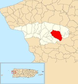 Location of Miraflores within the municipality of Añasco shown in red | |
 Miraflores Location of Puerto Rico | |
| Coordinates: 18°16′45″N 67°04′49″W / 18.279132°N 67.080144°WCoordinates: 18°16′45″N 67°04′49″W / 18.279132°N 67.080144°W[1] | |
| Commonwealth | |
| Municipality | |
| Area | |
| • Total | 3.71 sq mi (9.6 km2) |
| • Land | 3.65 sq mi (9.5 km2) |
| • Water | 0.06 sq mi (0.2 km2) |
| Elevation | 151 ft (46 m) |
| Population (2010) | |
| • Total | 567 |
| • Density | 155.3/sq mi (60.0/km2) |
| Source: 2010 Census | |
| Time zone | UTC−4 (AST) |

Miraflores is a barrio in the municipality of Añasco, Puerto Rico. Its population in 2010 was 567.[3][4][5]
Hurricane Maria[]
The barrio of Miraflores became inaccessible when Hurricane Maria hit Puerto Rico on September 20, 2017 and caused landslides and destruction.[6] Five months after the hurricane struck, engineers and officials were grappling with the massive amounts of repairs that were needed to PR-109 in Añasco and multiple other areas of this barrio and of Añasco, as a whole.[7][8]
Features and demographics[]
| Historical population | |||
|---|---|---|---|
| Census | Pop. | %± | |
| 1950 | 941 | — | |
| 1980 | 764 | — | |
| 1990 | 619 | −19.0% | |
| 2000 | 730 | 17.9% | |
| 2010 | 567 | −22.3% | |
| U.S. Decennial Census[9] 1899 (shown as 1900)[10] 1910-1930[11] 1930-1950[12] 1980-2000[13] 2010[14] | |||
Sectors[]
Barrios (which are like minor civil divisions)[15] in turn are further subdivided into smaller local populated place areas/units called sectores (sectors in English). The types of sectores may vary, from normally sector to urbanización to reparto to barriada to residencial, among others.[16][17][18]
The following sectors are in Miraflores barrio:[19]
Special communities[]
Since 2001 when law 1-2001 was passed,[20] measures have been taken to identify and address the high levels of poverty and the lack of resources and opportunities affecting specific communities in Puerto Rico. Initially there were 686 places that made the list.[21] By 2008, there were 742 places on the list of Comunidades especiales de Puerto Rico. The places on the list are barrios, communities, sectors, or neighborhoods and in 2004, Miraflores had made the list.[21][22][23]
See also[]
References[]
- ^ a b "US Gazetteer 2019". US Census. US Government.
- ^ U.S. Geological Survey Geographic Names Information System: Miraflores barrio
- ^ Picó, Rafael; Buitrago de Santiago, Zayda; Berrios, Hector H. Nueva geografía de Puerto Rico: física, económica, y social, por Rafael Picó. Con la colaboración de Zayda Buitrago de Santiago y Héctor H. Berrios. San Juan Editorial Universitaria, Universidad de Puerto Rico,1969.
- ^ Gwillim Law (20 May 2015). Administrative Subdivisions of Countries: A Comprehensive World Reference, 1900 through 1998. McFarland. p. 300. ISBN 978-1-4766-0447-3. Retrieved 25 December 2018.
- ^ Puerto Rico:2010:population and housing unit counts.pdf (PDF). U.S. Dept. of Commerce, Economics and Statistics Administration, U.S. Census Bureau. 2010.
- ^ "Añasco urge atención para recuperar carreteras, puentes y alcantarillados". La Isla Oeste (in Spanish). Retrieved 9 September 2020.
- ^ "Añasco urge atención para recuperar carreteras, puentes y alcantarillados". La Isla Oeste (in Spanish). 14 February 2018. Retrieved 9 September 2020.
- ^ "Añasco Miraflores PR-109 Kilometer 13.4". laislaoeste.com. Retrieved 9 September 2020.
- ^ "U.S. Decennial Census". United States Census Bureau. Archived from the original on February 13, 2020. Retrieved September 21, 2017.
- ^ "Report of the Census of Porto Rico 1899". War Department Office Director Census of Porto Rico. Archived from the original on July 16, 2017. Retrieved September 21, 2017.
- ^ "Table 3-Population of Municipalities: 1930 1920 and 1910" (PDF). United States Census Bureau. Archived (PDF) from the original on August 17, 2017. Retrieved September 21, 2017.
- ^ "Table 4-Area and Population of Municipalities Urban and Rural: 1930 to 1950" (PDF). United States Census Bureau. Archived (PDF) from the original on August 30, 2015. Retrieved September 21, 2014.
- ^ "Table 2 Population and Housing Units: 1960 to 2000" (PDF). United States Census Bureau. Archived (PDF) from the original on July 24, 2017. Retrieved September 21, 2017.
- ^ Puerto Rico:2010:population and housing unit counts.pdf (PDF). U.S. Dept. of Commerce Economics and Statistics Administration U.S. Census Bureau. 2010. Archived (PDF) from the original on 2017-02-20. Retrieved 2019-08-02.
- ^ "US Census Barrio-Pueblo definition". factfinder.com. US Census. Archived from the original on 13 May 2017. Retrieved 5 January 2019.
- ^ "Agencia: Oficina del Coordinador General para el Financiamiento Socioeconómico y la Autogestión (Proposed 2016 Budget)". Puerto Rico Budgets (in Spanish). Retrieved 28 June 2019.
- ^ Rivera Quintero, Marcia (2014), El vuelo de la esperanza: Proyecto de las Comunidades Especiales Puerto Rico, 1997-2004 (first ed.), San Juan, Puerto Rico Fundación Sila M. Calderón, ISBN 978-0-9820806-1-0
- ^ "Leyes del 2001". Lex Juris Puerto Rico (in Spanish). Retrieved 24 June 2020.
- ^ "PRECINTO ELECTORAL AÑASCO 040" (PDF). Comisión Estatal de Elecciones (in Spanish). PR Government. 21 September 2019. Retrieved 22 July 2020.
- ^ "Leyes del 2001". Lex Juris Puerto Rico (in Spanish). Retrieved 24 June 2019.
- ^ a b "Comunidades Especiales de Puerto Rico" (in Spanish). 8 August 2011. Retrieved 24 June 2019.
- ^ "Evoluciona el proyecto de Comunidades Especiales". El Nuevo Dia (in Spanish). 24 February 2017. Retrieved 24 June 2019.
- ^ "Ya es ley Oficina para el Desarrollo Socioeconómico y Comunitario". El Vocero de Puerto Rico (in Spanish). Retrieved 24 June 2019.
This Añasco, Puerto Rico location article is a stub. You can help Wikipedia by . |
- Barrios of Añasco, Puerto Rico
- Puerto Rico Senatorial district IV geography stubs