Mirik, Azerbaijan
Coordinates: 39°41′19″N 46°19′57″E / 39.68861°N 46.33250°E

Mirik | |
|---|---|
 Mirik | |
| Coordinates: 39°41′19″N 46°19′57″E / 39.68861°N 46.33250°E | |
| Country | |
| District | Lachin |
| Population (2015) | |
| • Total | 179 |
| Time zone | UTC+4 (AZT) |
| • Summer (DST) | UTC+5 (AZT) |
| Area code(s) | +994 26 |
Mirik is a village in the Lachin District of Azerbaijan.
History[]
The village was part of Azerbaijan until early 1990s. Then it was located in the Armenian-occupied territories surrounding Nagorno-Karabakh, coming under the control of ethnic Armenian forces during the First Nagorno-Karabakh War.
The village subsequently became part of the self-proclaimed Republic of Artsakh as part of its Kashatagh Province, referred to as Mirik (Armenian: Միրիկ).
It was returned to Azerbaijan as part of the 2020 Nagorno-Karabakh ceasefire agreement.
Historical monuments[]
- Temple, 16th-13th century Mirik village
- Castle, Mirik village of ancient times
- Sovme, 16th century Mirik village
- Spring (Behbudali spring), Mirik village of the XVIII century
- Mill, medieval village of Mirik
- Black roof, medieval
- Black roof, medieval Mirik village
- Black roof, medieval Mirik village
- Bridge, 1970 Mirik village 45 Cave (Dark kaha) Mirik village
- Burial mounds Mirik village
- Kalafalig (residence), Stone Age Mirik village
- Plot character carving Mirik gorge
- Stone figure with a plot Mirik gorge
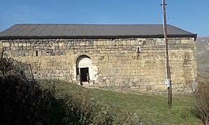
The temple was built in the western part of Mirik village (in the direction of Bozlu village) on bare slabs in the western part of the 16th century and is dated to 1662. remains.
Outside the basilica, the total length is 20.60 meters and the width is 12 meters. Local pud stones and lime were used in the construction of the monument, which is 1.55 meters thick. The area around the only exit door and the southern facade are decorated with interesting ornaments and carvings. In the interior of the monument, a sundial is engraved on the stone.
The interior of the basilica is illuminated by 6 windows that extend from the inside. The inner columns of the building are circular at equal distances. The protrusions of the arch stones extend to the cornerstones of the building and are woven with special precision, giving the building a special beauty. The ceiling of the building is fixed to the side walls with fragmented stones. The construction of the monument gives grounds to say that the use of this monument does not include the performance of religious rites.

We still do not know whether the Armenians changed the walls of the monument after the occupation. The only thing known is that the Armenian government has given the monument the status of an Armenian church since 2006 by a special decision.
During the Soviet era, this monument first served as the village's food warehouse and later as the village's house of culture.
Geography and climate[]
Kirkhbulag forest (view from the side of the castle) Mirik village is located on the left bank of the Minkend branch of the Hakari river, 2 km west of Bozlu village, at an altitude of 1440-1520 meters above sea level.
Rivers flowing through the village: Mirik river, Dalikli water, Minkend branch of Hakari river.
Springs in the village[]
Alishan spring, Hummat spring, Navli spring, Shirin spring, 3 Shor spring, Korja spring, Dash spring, Shirin spring, Gizlar spring, Hamza spring, Mammo spring, 2 Tursh spring, Selim spring, Sharih spring, Sheyin spring, Karba spring Behbudali spring, Goybulag, Sona spring, Kirkhbulag.
Village place names and pastures[]
Mirik river (rivers-Apple orchard, cherry orchard), Karim's orchard, Beyler's-Sevdimali's candle, Jabbar's candle, Gadmallar's garden, Gulmallar's garden, Alakbar's garden, Emral's garden, Mollaushagi's garden, Mehti's garden, Gormat's garden, Hum Hill, Curves, Agalar's place, Novruz's place, Alisha's forest, Yellow hill, Girrov pine, Stone road, Qasim planting, Hasan's forest, Indirect road, Wide valley, Burning breast, Hacha dash, Ganshar trap, Mirik north, Roof north, Hur north , Nagy steppes, Edilkhan pit, Top stone, Sweet spring gorge, Mirik south, Stone south, Mumlu rock, Shaver steppe, Chakhmakhli south, Golden rock, Tumors, Castle head, Parca forest, Kirkhbulag forest, Galaxi branch, Bayg branch , Kirkhbulag, Dalikli's kahasi, Dalikli's gorge, Gullagan steppe, Kalafalig, Sheyin marzi, Yurdlar, Gafar trap, Allahverdiolan valley, Hills, Barley valley, Goybulag, Sonabulagi, Dry valley, Ibrahim Khalil fortress, Galax trap.
Population[]
The ethnic composition of Mirik village consists of Azerbaijani Turks. In fact, the population is over 2,000.
Generations[]
- Əhmədlər – qolları: Qorcular, Nurular, Ələsgərlər, Kərbəlayı, Suleymanlar (və ya Kərimlər)
- Qəlilər (və ya Qəllər) – qolları: Gulmallar, Niftallar, Hüsenyuşağı, Nəcəflilər (və ya Qədmallar)
- Hüsenallar
- Şirinlər
- Hopurlar ( və ya Hopurru) – qolları: Həsənlər, Abbaslar, Alirzalar, Alişanlar
- Qaraxanlar – qolu: Həşimlər
- Urtikli (Hurtikli)
- İmanlılar
- Dəmolar
- Kolanılar
Economy[]
The main occupations of the population were gardening, gardening, beekeeping, animal husbandry and, at least in part, weaving. Recently, the tendency to trade in the village has increased. Mirik village was one of the most prestigious places in the region for the production of agricultural products, especially potatoes. The houses of the population consisted of kahas, black roofs, and later modern village houses with modern balconies.
References[]
- Mirik, Azerbaijan at GEOnet Names Server
- State Statistics Committee of the Republic of Azerbaijan (2019). "Classification of administrative territories"

Capital: Berdzor | ||
| Urban communities |  | |
| Rural communities | ||
| Not under Artsakh control |
| |
- Villages in Azerbaijan
- Populated places in Lachin District