Misato, Saitama (city)
Misato
三郷市 | |
|---|---|
 Misato City Hall | |
 Flag  Seal | |
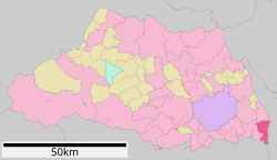 Location of Misato in Saitama Prefecture | |
 Misato Location of Misato in Saitama Prefecture | |
| Coordinates: 35°49′48.5″N 139°52′20.4″E / 35.830139°N 139.872333°ECoordinates: 35°49′48.5″N 139°52′20.4″E / 35.830139°N 139.872333°E | |
| Country | Japan |
| Region | Kantō |
| Prefecture | Saitama |
| Area | |
| • Total | 30.13 km2 (11.63 sq mi) |
| Population (February 2021) | |
| • Total | 142,835 |
| • Density | 4,700/km2 (12,000/sq mi) |
| Time zone | UTC+9 (Japan Standard Time) |
| - Tree | Castanopsis |
| - Flower | Rhododendron |
| - Bird | Tachybaptus ruficollis |
| Phone number | 048-953-1111 |
| Address | 648-1 Hanawada, Misato-shi, Saitama-ken 341-8501 |
| Website | Official website |


Misato (三郷市, Misato-shi) is a city located in Saitama Prefecture, Japan. As of 1 January 2021, the city had an estimated population of 142,835 in 65,950 households and a population density of 4700 persons per km².[1] The total area of the city is 30.13 square kilometres (11.63 sq mi).
Geography[]
Misato is located in the extreme southeastern corner Saitama Prefecture. The Edogawa River runs along the eastern border of the city, the Naka River runs along the western border, and the Oba River runs through the central part of the city. Located in the middle of the Kantō Plain, the land is generally flat, with the highest point being about 8 meters above sea level. The city is approximately 20 kilometers from downtown Tokyo.
Surrounding municipalities[]
Tokyo Metropolis
- Katsushika-ku
- Nagareyama
- Matsudo
Climate[]
Misato has a Humid subtropical climate (Köppen Cfa) characterized by warm summers and cool winters with light to no snowfall. The average annual temperature in Misato is 15.1 °C. The average annual rainfall is 1387 mm with September as the wettest month. The temperatures are highest on average in August, at around 26.9 °C, and lowest in January, at around 4.4 °C.[2]
Demographics[]
Per Japanese census data,[3] the population of Misato has increased rapidly from the 1960s, and has been relatively steady for the past 30 years.
| Year | Pop. | ±% |
|---|---|---|
| 1920 | 12,825 | — |
| 1930 | 13,317 | +3.8% |
| 1940 | 14,476 | +8.7% |
| 1950 | 16,711 | +15.4% |
| 1960 | 17,735 | +6.1% |
| 1970 | 42,753 | +141.1% |
| 1980 | 98,223 | +129.7% |
| 1990 | 128,376 | +30.7% |
| 2000 | 131,047 | +2.1% |
| 2010 | 131,418 | +0.3% |
History[]
The area of modern Misato was originally part of Shimōsa Province, and was transferred to Musashi Province in 1683. The villages of Hikonari, Waseda, Togasaki and Yagisato were created within Kitakatsushika District, Saitama with the establishment of the modern municipalities system on April 1, 1889. Togasaki and Yagisato merged on July 1, 1933 to form the village of Towa. On September 30, 1956, Hikonari, Waseda and Towa merged to form the village of Misato, which was raised to town status on October 1, 1964. The area experienced rapid population growth in the 1960s and 1970s with the large-scale construction of public housing new town developments.
Misato was elevated to city status on May 3, 1972.
Government[]
Misato has a mayor-council form of government with a directly elected mayor and a unicameral city council of 22 members. Misato contributes two members to the Saitama Prefectural Assembly. In terms of national politics, the city is part of Saitama 14th district of the lower house of the Diet of Japan.
Economy[]
Due to this location, Misato is primarily a bedroom community with a significant percentage of its population commuting to the Tokyo metropolis for work.
Education[]
Misato has 19 public elementary schools and eight public middle schools operated by the city government and three public high schools (Misato North High School, Misato Technical High School, Misato High School) operated by the Saitama Prefectural Board of Education, The prefecture also operates one special education school for the handicapped.
Transportation[]
Railway[]
![]() JR East – Musashino Line
JR East – Musashino Line
- Misato - Shin-Misato
![]() Metropolitan Intercity Railway Company - Tsukuba Express
Metropolitan Intercity Railway Company - Tsukuba Express
Highway[]
Noted people from Misato[]
- Yūya Uchida, voice actress
- Mika Kikuchi, actress
- Shunketsu Yūji, sumo wrestler
- Tomoyuki Sakai, professional soccer player
- Junko Furuta, murder victim
References[]
- ^ "Misato city official statistics" (in Japanese). Japan.
- ^ Misato climate data
- ^ Misato population statistics
External links[]
| Wikimedia Commons has media related to Misato, Saitama (city). |
- Official Website (in Japanese)
| show Authority control |
|---|
- Cities in Saitama Prefecture
- Misato, Saitama (city)