Missisquoi River Bridge
Missisquoi River Bridge | |
|---|---|
 | |
| Coordinates | 45°0′49″N 72°35′16″W / 45.01361°N 72.58778°WCoordinates: 45°0′49″N 72°35′16″W / 45.01361°N 72.58778°W |
| Carries | |
| Crosses | Missisquoi River |
| Locale | The Canada–United States border between Richford, Vermont and Sutton, Quebec |
| Characteristics | |
| Design | Parker through truss bridge |
| History | |
| Opened | 1929 |
| Statistics | |
Missisquoi River Bridge | |
| Area | less than 1 acre (0.40 ha) |
| Built by | Pittsburgh-Des Moines Steel Co. |
| MPS | Metal Truss, Masonry, and Concrete Bridges in Vermont MPS |
| NRHP reference No. | 90001494[1] |
| Added to NRHP | October 11, 1990 |
| Location | |
 | |

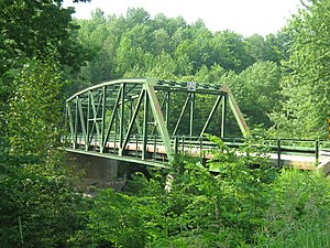
The Mississquoi River Bridge (in Canada Pont de la Vallée) is a steel truss bridge, spanning the Missisquoi River between Richford, Vermont and Sutton, Quebec on the Canada–United States border. It connects Chemin de la Vallée Missisquoi in Sutton with Vermont Route 105A in Richford, between the border stations of the East Richford–Glen Sutton Border Crossing. The bridge was built by the state of Vermont in 1929, and is one of two in the state built by the Pittsburgh-Des Moines Steel Company. It was listed on the United States National Register of Historic Places in 1990.[1]
Description and history[]
The Missisquoi River Bridge is located in northeastern Richford and southeastern Sutton, at a point where the Missisquoi River flows across the international border (an east-west line) in a roughly southwesterly direction. The bridge is just northwest of the small village of East Richford, with only Canada's Glen Sutton border station in the immediate vicinity north of the border. The bridge is a two-span metal Parker through truss structure, 205 feet (62 m) in length, and was assembled with riveted construction. The trusses rest on abutments and a pier of poured concrete. One span is 150 feet (45.72 m) long, and the other is 50 feet (15.24 m) long. The bridge is 21.6 feet (6.58 m) wide, and carries two lanes of traffic on a concrete deck. The maximum truss depth is 19 feet (5.79 m) and the end portals have clearance of 15 feet (4.57 m).[2]
The bridge was built by the state of Vermont in 1929, as part of a program to build more than 1,200 bridges after devastating floods in 1927. The bridge was manufactured by the Pittsburgh-Des Moines Steel Company, and is only one of two known bridges in the state to be built by that firm. The bridge exhibits characteristics of standardized design developed by the state to speed construction of bridges at the time. The border crossing point was at the time economically important, providing access to the markets of southern Quebec to the industries in Richford.[2]
The bridge is currently closed and is being rehabilitated, with a re-opening date scheduled for October 16, 2018.[citation needed][needs update]
Border crossing[]
The East Richford–Glen Sutton Border Crossing connects the towns of Sutton, Quebec and Richford, Vermont via the Missisquoi River Bridge on the Canada–US border. In 1936, the United States built a large border station which is still in use today, and is also listed on the National Register of Historic Places.
See also[]
- National Register of Historic Places listings in Franklin County, Vermont
- List of bridges on the National Register of Historic Places in Vermont
- List of Canada–United States border crossings
References[]
- ^ Jump up to: a b "National Register Information System". National Register of Historic Places. National Park Service. July 9, 2010.
- ^ Jump up to: a b Mary Hotaling (1990). "NRHP nomination for Missisquoi River Bridge". National Park Service. Retrieved 2016-11-13. with photos from 1985
| Wikimedia Commons has media related to Missisquoi River Bridge. |
| hide | |
|---|---|
| Topics | |
| Lists by state |
|
| Lists by insular areas | |
| Lists by associated state | |
| Other areas | |
| Related | |
| |
- Bridges on the National Register of Historic Places in Vermont
- National Register of Historic Places in Franklin County, Vermont
- Bridges completed in 1929
- Bridges in Franklin County, Vermont
- Buildings and structures in Richford, Vermont
- Road bridges in Vermont
- Road bridges in Quebec
- Canada–United States bridges
- Steel bridges in the United States
- Steel bridges in Canada
- Parker truss bridges in the United States
- Parker truss bridges in Canada
- 1929 establishments in Vermont