Miyako Strait
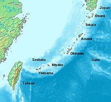
The Miyako Strait (宮古海峡, Miyako Kaikyō, Miyako: Myāku Kaikyū), also known as the Kerama Gap, is a waterway which lies between Miyako Island and Okinawa Island consisting of an approx. 250km wide passageway with international waters and airspace.[1] It is the widest strait in the Ryukyu Islands.
Political significance[]
The Miyako Strait is of global geopolitical significance, as it is one of the few international waterways for China's People's Liberation Army Navy to access the Pacific Ocean from the East China Sea.[2] Japan insists that China has committed to informing them in advance if their Navy sails through the strait, a claim that the Chinese deny has ever been agreed upon. The PLA Navy used the strait on a large scale for the first time in April 2010,[3] an act which has since become a commonplace practice for them to conduct military exercises in the Pacific.[4][5]
Cultural significance[]
The Miyako Strait represents a cultural and linguistic split between the Southern and Northern Ryukyuan languages, with the north being more influenced by Japanese culture. The Northern Ryukyu Islands have historically been more advanced (socially, technologically, and infrastructurally) than the Southern Ryukyu Islands.[6]
| hide | ||
|---|---|---|
| Core city | ||
| Cities | ||
| Districts | ||
List of mergers in Okinawa Prefecture
| ||
References[]
- ^ Diplomat, Franz-Stefan Gady, The. "China Flies 6 Heavy Long-Range Bombers Near Japan". The Diplomat. Retrieved 2018-02-27.
- ^ "China dispatches one of its largest air force fleets ever near Okinawa in show of force to Japan". South China Morning Post. 25 September 2016. Retrieved 26 September 2016.
- ^ China's Navy Gets Its Act Together, and Gets Aggressive | Danger Room | Wired.com
- ^ China Says No Japan Maritime Deal in Place
- ^ US can no longer contain China within First Island Chain: Duowei Archived 2014-11-03 at the Wayback Machine. Retrieved 2013-11-04.
- ^ Kerr, George H. Okinawa: History of an Island People. Tokyo: Charles E. Tuttle Company, 1958. 116-117.

- Ryukyu Islands
- Straits of Japan
- Landforms of Okinawa Prefecture