Mobeetie, Texas
Mobeetie, Texas | |
|---|---|
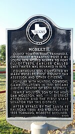 Texas Historical marker for Mobeetie | |
 | |
| Coordinates: 35°32′1″N 100°26′21″W / 35.53361°N 100.43917°WCoordinates: 35°32′1″N 100°26′21″W / 35.53361°N 100.43917°W | |
| Country | United States |
| State | Texas |
| County | Wheeler |
| Area | |
| • Total | 0.61 sq mi (1.58 km2) |
| • Land | 0.61 sq mi (1.58 km2) |
| • Water | 0.00 sq mi (0.00 km2) |
| Elevation | 2,641 ft (805 m) |
| Population (2010) | |
| • Total | 101 |
| • Estimate (2019)[2] | 95 |
| • Density | 155.74/sq mi (60.09/km2) |
| Time zone | UTC-6 (Central (CST)) |
| • Summer (DST) | UTC-5 (CDT) |
| ZIP code | 79061 |
| Area code(s) | 806 |
| FIPS code | 48-48852[3] |
| GNIS feature ID | 1363014[4] |

Mobeetie is a city in northwestern Wheeler County, Texas, United States, located on Sweetwater Creek and State Highway 152. Its population was 101 at the 2010 census, six below the 2000 figure.[5]
History[]
Mobeetie (formerly known as "Cantonment Sweetwater") was a trading post for hunters and trappers for nearby United States Army outpost Fort Elliott. It was first a buffalo hunters' camp unofficially called "Hidetown". Connected to the major cattle-drive town of Dodge City, Kansas, by the Jones-Plummer Trail, Mobeetie was a destination for stagecoach freight and buffalo skinners. As it grew, the town supported the development of cattle ranches within a hundred-mile radius by supplying the staple crops.1
The first formal name for the town was "Sweetwater". It was located on the North Fork Red River, a tributary of the Red River of the South. Nearby Fort Elliott, developed to protect the buffalo trade from Indian raiders, stimulated further growth of the town. On January 24, 1876, the "Sweetwater Shootout" occurred. Anthony Cook (Corporal "Sergeant" Melvin A. King; of the then-4th Cavalry Company H, stationed at Fort Elliot) shot and killed Mollie Brennan (a dancehall girl and former prostitute). Sgt. King then wounded Bat Masterson, who in turn killed him (King may have shot Masterson first and then killed Brennan; accounts vary).[6][7] Texas cattleman Charles Goodnight said about the town: "I think it was the hardest place I ever saw on the frontier except Cheyenne, Wyoming."
When the town applied for a post office in 1879, the name "Sweetwater" was already in use. The town took the new name of "Mobeetie", believed to be a Native American word for Sweetwater. It was allegedly later revealed that the word, in fact, meant "buffalo dung."[8]
Because of the presence of Fort Elliott and Mobeetie's importance as a commercial center, Wheeler County became the first politically organized county in the Texas Panhandle, in 1879, followed by Oldham County at Tascosa, now a ghost town. Mobeetie became the first county seat for Wheeler County. From 1880 to 1883, the notorious Robert Clay Allison ranched with his two brothers, John William and Jeremiah Monroe, 12 miles northeast of town, at the junction of the Washita River and Gageby Creek. One day, Allison rode through Mobeetie drunk and naked.[9][10] Allison married America Medora "Dora" McCulloch in Mobeetie on February 15, 1881.[11]
Lester Fields Sheffy, in The Life and Times of Timothy Dwight Hobart, 1855-1935: Colonization of West Texas (1950), describes Mobeetie as:
Mobeetie was perhaps the most typical frontier town in the American Southwest on account of its background and the cosmopolitan character of its people. It was never a large town as early plains towns went, but it was a busy and a thriving center. When [land surveyor] Timothy Dwight Hobart arrived at Mobeetie in 1886, the town was in the heyday of its existence. Its several merchandise stores and other business firms, its blacksmith shops and livery stables, its law offices and real estate agencies, its nine saloons, and its fort, its substantial rock school building, and its church organizations were a splendid index to the varied interest and character of the people. Mobeetie had all the elements of people that it took to make a typical frontier village. It had its buffalo hunters and its bull whackers, its soldiers and its scouts, its indolents and its prostitutes, its substantial businessmen, and its legal fraternity. ...
One of the most stabilizing influences among the citizenry of Mobeetie was its soldiers. While most of the soldiers themselves were transient and never became permanent citizens of the community, they exercised a restraining influence over the town and surrounding country because of the feeling of security which their presence gave to the region. ... At times there was dissension between the soldiers and the civilians, but the most cordial relationships existed at all times between the officers at the fort and the more substantial business leaders of the town. The presence of several hundred soldiers at the fort increased the profits of the merchants, the saloon keepers, the dance halls, and brought considerable ready cash into the community...[12]
When Army Lieutenant Colonel John Porter Hatch was reassigned from Fort Elliott in 1881, the Wheeler County Commissioners Court authorized a resolution honoring Hatch for his service: "He has proven himself at all times agreeable to the citizens of this section and willing to aid them as a community or as individuals whenever such aid has been required, and to the fullest extent of his power."[12]

In the 1880s, Temple Lea Houston, the youngest son of Sam Houston, was the district attorney of the 35th Judicial District of Texas, when then encompassed 15 counties in the Texas Panhandle. The district was based at the time in the courthouse at Mobeetie. Houston was also a member of the Texas State Senate from 1885 to 1889 and later moved to Oklahoma, where he worked for statehood. An NBC television series, Temple Houston, which aired from 1963 to 1964, is loosely based on his life, with Jeffrey Hunter in the starring role.[13]
At its peak in 1890, the town had over 400 people, but Mobeetie's boom days ended when Fort Elliott closed that same year. Further decline came with the tornado of May 1, 1898, and then the loss of the county seat, in 1907, to Wheeler. In 1929, Wheeler moved two miles when the Panhandle and Santa Fe Railway built nearby tracks. The town steadily grew again until the start of World War II brought a peak around 500.
Little remains of the Old Mobeetie. Sheffy, in The Life and Times of Timothy Dwight Hobart writes:
The new Mobeetie stands almost within gunshot of the old town in the midst of a great agricultural and stock-raising region. The worn and unkept buildings of the old town speak eloquently of its hard struggle to survive. They should be preserved as a lasting monument to the struggle and achievement of a people who wrought well in laying the foundations of Anglo-American civilization in the Southwest."[12]
The Pioneer West Museum in Shamrock preserves the heritage of the Old Mobeetie region. Its contains an exhibit on Fort Elliott.
Mobeetie is also known as the birthplace of a member of the 1919 World Series champion Cincinnati Reds infielder and catcher Morrie Rath. Rath was born on Christmas Day 1886.
Geography[]
Mobeetie is located in the Texas Panhandle northeast of Sweetwater Creek along Texas State Highway 152, Farm to Market Road 48, and Farm to Market Road 1046. Pampa lies about 30 miles to the west, and Wheeler is about 10 miles to the east along route 152. The Fort Elliot historical site is about one mile west along SH 152.[14][15]
According to the United States Census Bureau, the city has a total area of 0.6 sq mi (1.6 km2), all land.
Demographics[]
| Historical population | |||
|---|---|---|---|
| Census | Pop. | %± | |
| 1980 | 291 | — | |
| 1990 | 154 | −47.1% | |
| 2000 | 107 | −30.5% | |
| 2010 | 101 | −5.6% | |
| 2019 (est.) | 95 | [2] | −5.9% |
| U.S. Decennial Census[16] | |||
As of the census[3] of 2000, 107 people, 48 households, and 28 families were residing in the city. The population density was 175.3 people per square mile (67.7/km2). The 68 housing units averaged 111.4/sq mi (43.0/km2). The racial makeup of the city was 99.07% White and 0.93% Native American. Hispanics or Latinos of any race were 6.54% of the population.
Of the 48 households, 27.1% had children under the age of 18 living with them, 50.0% were married couples living together, 8.3% had a female householder with no husband present, and 39.6% were not families. About 37.5% of all households were made up of individuals, and 20.8% had someone living alone who was 65 years of age or older. The average household size was 2.23, and the average family size was 2.97.
In the city, theage distribution was 27.1% under 18, 3.7% from 18 to 24, 24.3% from 25 to 44, 21.5% from 45 to 64, and 23.4% who were 65 or older. The median age was 41 years. For every 100 females, there were 101.9 males. For every 100 females age 18 and over, there were 95.0 males.
The median income for a household in the city was $35,625, and for a family was $39,583. Males had a median income of $35,417 versus $23,125 for females. The per capita income for the city was $16,059. There were no families and 2.9% of the population living below the poverty line, including no one under 18 or over 64.
Education[]
The City of Mobeetie is served by the Fort Elliott Consolidated Independent School District. The former merged into FECISD on August 10, 1991.[17]
Climate[]
According to the Köppen climate classification, Mobeetie has a semiarid climate, BSk on climate maps.[18]
References[]
- ^ "2019 U.S. Gazetteer Files". United States Census Bureau. Retrieved August 7, 2020.
- ^ Jump up to: a b "Population and Housing Unit Estimates". United States Census Bureau. May 24, 2020. Retrieved May 27, 2020.
- ^ Jump up to: a b "U.S. Census website". United States Census Bureau. Retrieved 2008-01-31.
- ^ "US Board on Geographic Names". United States Geological Survey. 2007-10-25. Retrieved 2008-01-31.
- ^ "Population and Housing Unit Counts, 2010 Census of Population and Housing" (PDF). Texas: 2010. Retrieved 2017-01-05.
- ^ ""Bat Masterson and the Sweetwater Shootout" by Gary L. Roberts". Archived from the original on 2007-09-30. Retrieved 2007-08-02.
- ^ ""Charlie Siringo, Letter Writer" by Mark Dworkin". Archived from the original on 2011-06-04. Retrieved 2007-08-02.
- ^ https://www.houstonchronicle.com/news/columnists/native-texan/article/Get-a-load-of-this-Panhandle-town-earned-name-in-6485534.php
- ^ Clay Allison from the Handbook of Texas Online
- ^ Clay at Legends of America Archived 2007-08-15 at the Wayback Machine
- ^ "The Allison Clan - A Visit" by Sharon Cunningham Archived 2007-09-27 at the Wayback Machine
- ^ Jump up to: a b c Lester Fields Sheffy, The Life and Times of Timothy Dwight Hobart, 1855-1935: Colonization of West Texas (Canyon, Texas: Panhandle-Plains Historical Society, 1950), pp. 148-150, 157.
- ^ Billy Hathorn, "Roy Bean, Temple Houston, Bill Longley, Ranald Mackenzie, Buffalo Bill, Jr., and the Texas Rangers: Depictions of West Texans in Series Television, 1955 to 1967", West Texas Historical Review, Vol. 89 (2013), pp. 106-109
- ^ Mobeetie, TX, 7.5 Minute Topographic Quadrangle, USGS, 1963
- ^ Texas Atlas & Gazetteer, DeLorme, 4th ed. 2001, p.31 ISBN 0-89933-320-6
- ^ "Census of Population and Housing". Census.gov. Retrieved June 4, 2015.
- ^ "CONSOLIDATIONS, ANNEXATIONS AND NAME CHANGES FOR TEXAS PUBLIC SCHOOLS" (PDF). Texas Education Agency. 2018-09-10. Retrieved 2019-10-30.
- ^ Climate Summary for Mobeetie, Texas
1The Texas Panhandle Frontier; Rathjen, Frederick W; (1973); Texas Tech University Press. ISBN 0-89672-399-2.
External links[]
- Mobeetie, Texas from the Handbook of Texas Online

- Cities in Texas
- Cities in Wheeler County, Texas