Moffat
Moffat
| |
|---|---|
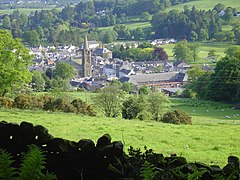 Moffat from the surrounding hills | |
 Moffat Location within Dumfries and Galloway | |
| Population | 2,510 (mid-2016 est.)[1] |
| OS grid reference | NT085052 |
| Council area | |
| Lieutenancy area | |
| Country | Scotland |
| Sovereign state | United Kingdom |
| Post town | MOFFAT |
| Postcode district | DG10 |
| Dialling code | 01683 |
| Police | Scotland |
| Fire | Scottish |
| Ambulance | Scottish |
| UK Parliament | |
| Scottish Parliament | |

Moffat (Scottish Gaelic: Mofad) is a former burgh and parish in Dumfriesshire, now part of the Dumfries and Galloway local authority area in Scotland. It lies on the River Annan, with a population of around 2,500.[2] It was a centre of the wool trade and a spa town.
Moffat is around 59 miles (95 kilometres) to the southeast of Glasgow, 51 miles (82 kilometres) to the south of Edinburgh, 21 miles (34 kilometres) to the north of Dumfries and 44 miles (71 kilometres) to the north of Carlisle.
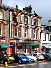
The Moffat House Hotel, located at the northern end of the High Street, was designed by John Adam. The nearby Star Hotel, a mere 20 ft (6 m) wide, was listed in the Guinness Book of Records as the narrowest hotel in the world.[3] Moffat won the Britain in Bloom contest in 1996.
Moffat is home to Moffat toffee.
The town is held to be the ancestral seat of Clan Moffat. The Devil's Beef Tub near Moffat was used by the members of Clan Moffat and later the members of Clan Johnstone to hoard cattle stolen in predatory raids.
Early tourism as a spa town[]

From 1633 Moffat began to grow from a small village into a popular spa town. The sulphurous and saline waters of Moffat Spa were believed to have healing properties, specifically curative for skin conditions, gout, rheumatism and stomach complaints.[4] In 1730 these were complemented by the addition of iron springs. During the Victorian era the high demand led to the water being piped down from the well to a tank in Tank Wood and on to a specially built bath house in the town centre (now the Town Hall).[5]
Luxurious hotels sprang up to accommodate the increasing numbers of tourists. One such hotel opened during Moffat's heyday in 1878, Moffat's Hydropathic hotel was destroyed in a fire in 1921.
The old well was refurbished in the mid 1990s, and is still accessible by vehicle and foot. The water smells very strongly of sulphur, with deposits on the walls and well itself. At the grand reopening of the well, people visiting were encouraged to drink a glass full.
The well can be reached by following Haywood Road and climbing up Tank Wood (on the right at the top): the path at the end was the original route to the well. An alternative is to drive or walk up Well Road, and eventually, one reaches the Well Cottage and the car park for the well. As stated, when the water was first piped into town for the baths, it was pumped uphill to a tank in the appropriately named Tank Wood, before travelling back downhill to the bath house.
Larchhill Well was a chalybeate well located on Old Well Road near Wellwoodhead Cottage. The well is no longer visible.
Origin of the name[]
The name of the town Moffat is an endonym, a Gaelic Anglicization of Movvat, which is of Norman origin.[6] This quasi-place-name has been theorized to be translated as "the long plain," which could be derived from two elements: magh ("plain") and fada ("long").[6] The area of Moffat does not resemble a "long plain" at all, so it is thought that "Moffat" was the locals' attempt at pronouncing "Mowat" as the Mowats, Moffats, and Montaltos all share a common progenitor and at one time bore identical arms.[7] Records as far back as the 1300s show an individual named "Monte Alto, pronounced 'Mowat.'" This is an example of the Anglicization of a Norman name. A good example of this is Belvoir Castle which is pronounced "Beaver Castle." The castle in no way resembles a furry aquatic mammal, but it was easier for the locals to pronounce. Similarly, the name Monte Alto (pronounced "Mowat") was written as Movvat, and from there "very easily corruptible to Moffat".[7] There are no records of the name "Moffat" prior to the Norman Mowat family appearing in the area. A Norman motte ruin is still visible on the Northeast side of town near Alton House.
Governance[]
Moffat is in the parliamentary constituency of Dumfriesshire, Clydesdale and Tweeddale, David Mundell is the current Conservative Party member of parliament.
It is part of the South Scotland region in the Scottish Parliament, being in the constituency of Dumfriesshire. Oliver Mundell of the Conservatives is the MSP.
Prior to Brexit, for the European Parliament its residents voted to elect MEPs for the Scotland constituency.
Wool trade[]

Moffat was a notable market in the wool trade, and this is commemorated with a statue of a ram by William Brodie in the town's marketplace. The ram was presented to the town by William Colvin, a local businessman, in 1875. The ram's ears are missing, as they have been since it was first presented.
Notable people[]
- Danny Bhoy, comedian.
- Sir Thomas Bouche civil engineer and designer of the first Tay Bridge.
- William Carruthers, botanist.
- William Dickson (1751-1823), was secretary to the Governor of Barbados for 13 years. There he witnessed slaves being brutally treated. From January to March 1792 he toured Scotland from Kirkcudbright to Nairn presenting evidence of the evils of the slave trade. This evidence was summarised in 'An abstract of the evidence delivered before a select committee of the House of Commons'.[8] He wrote a book on the subject entitled Mitigation of Slavery.
- Air Chief Marshal Hugh Dowding, commander of RAF Fighter Command during the Battle of Britain, was born at St Ninian's School, Moffat in 1882. The former school is now sheltered housing for RAF veterans. There is a memorial to Dowding in Station Park. It is in a local red sandstone with a bronze memorial tablet on the wall and RAF crest badges on the flanking 'wings'. The architect and designer was D. Bruce Walker and the sculptor Scott Sutherland RSA.
- James Fraser, Scottish international footballer,
- Ellen or Helen Hyslop, was said to have had a daughter, Helen or Ellen Armstrong, fathered by the poet Robert Burns. The gravestone of the mother and her daughter is to be found in the old cemetery. Unusually for Victorian memorials, the name of the father is not recorded on the stone. Ellen died aged 87 and her daughter lived until the age of 98.
- James D. Murray, mathematical biologist.
- James B Niven, Scottish international footballer.
- Ivor Robson, the official starter for the Open golf tournament since 1975.[9]
- D. E. Stevenson (1892–1973), author and cousin to Robert Louis Stevenson.
Famous and infamous visitors[]
Robert Burns came for the waters and frequented the local bars.
The infamous murderer William Hare may have stayed in the Black Bull Hotel during his escape to Ireland after turning King's evidence against William Burke in the Burke and Hare murders.
John Loudon McAdam, Scottish engineer and road-builder, died in Moffat and is buried there.
In 1935, the remains of the victims of the Lancaster murderer, Dr Buck Ruxton, were found in a stream near The Devil's Beef Tub. A landmark case in legal history, it was the first in which the murderer was successfully convicted using the type of highly sophisticated forensic techniques which are taken for granted in the 21st century. The bridge at the top is still used to this day - near the very top it is a switchback that is not quite wide enough for two vehicles to pass on. The area is colloquially known as "Ruxton's Dump". The bridge from which Ruxton threw the parcelled remains has been straightened and widened; Gardenholme Linn, the deep wooded defile into which the packages were thrown is on the east side of the road (A701).[citation needed]
Samuel Wallace, a Victoria Cross recipient, died in the town.
Tourism[]

The town attracts many tourists all year round, both as visitors and as walkers in the surrounding hills. Notable buildings include the Annandale Arms Hotel and Restaurant which has been awarded several AA rosettes, Real and Local Food medals and four stars from Food Review Scotland.
Shops include the Moffat Toffee Shop and The Edinburgh Woollen Mill, while its restaurants and cafes include The Bombay Cuisine, Claudio's, Arietes, The Rumblin' Tum, The Balmoral and the Buccleuch Arms Hotel and Restaurant. The Buccleuch has also been awarded Gold in Visitscotland's Green Tourism Business Scheme.[10]
Moffat also has a recreation park with a boating pond and a memorial to Air Chief Marshal Hugh Dowding.
There is an official Camping and Caravanning Club campsite (for tents, caravans and motorhomes) that is open all year as of 13 March 2008. This is situated next to the Hammerlands Centre - a combination garden centre, gift shop, restaurant, fish farm and children's play area with farmyard animals.
For walkers there is also the Gallow Hill. Moffat is also situated only a few miles from the Southern Upland Way where it passes through Beattock, and the Sir Walter Scott Way starts here.
Northeast of Moffat is the Grey Mare's Tail waterfall. This hanging-valley waterfall is 60m tall and lies within a nature reserve.[11]
Education[]
Moffat Academy teaches pupils of Nursery, Primary and Secondary School age, there are currently just over 520 pupils taught at the school. It was in its former location in the north of the town since 1834. In February 2010 the school moved to a new site in the south-east of the town on Jeff Brown Drive.
Sport and recreation[]


Moffat RFC caters for all ages. The 1st XV plays in the Scottish Rugby Union league structure. They are also known as "The Rams" after the statue in the High Street. The ground wholly owned by the club is situated at The Holm, Selkirk Road.[12]
Moffat's main football club is Upper Annandale F.C., who represent the town in the South of Scotland Football League.
Moffat Golf Club was founded in 1884. In 1904, Ben Sayers of North Berwick was invited to design the present 18-hole course. Located high on Coats Hill overlooking the town, it is some 670 feet above sea level.[13]
A 53-mile (85 km) long-distance walking route called Annandale Way[14] running through Annandale (from the source of the River Annan to the sea) was opened in September 2009.[15] The route passes very close to the town of Moffat, and a diversion from it into the town adds very little in distance.
The nearby Moffat Hills[16] offer many walking routes, and the town itself is the closest base for access to these hills.
References[]
- ^ "Mid-2016 Population Estimates for Settlements and Localities in Scotland". National Records of Scotland. 12 March 2018. Retrieved 30 December 2020.
- ^ "Scotland (United Kingdom): Council Areas & Localities - Population Statistics, Charts and Map".
- ^ "The Famous Star Hotel, Moffat – Hotel".
- ^ Hewison, James K. (1912). Cambridge County Geographies Dumfrieshire. Cambridge University Press.
- ^ Bradshaw's Handbook, 1863: Beattock
- ^ Jump up to: a b Moffatt Name Meaning and Origin Retrieved 2007-11-18
- ^ Jump up to: a b Major Francis Moffat of that Ilk, The Moffats:
- ^ "Slavery".
- ^ "Under starter's orders: Voice of the Open Ivor Robson looks back at his 41 years". 31 July 2015.
- ^ Keywords. "Accommodation - VisitScotland". Guide.visitscotland.com. Archived from the original on 14 July 2012. Retrieved 2 March 2013.
- ^ Scotland, National Trust for (9 February 2019). "Grey Mare's Tail". National Trust for Scotland. Retrieved 10 February 2019.
- ^ http://www.moffat-rugby.com Archived 20 April 2007 at the Wayback Machine
- ^ "Moffat Golf Club". Moffat Golf Club. Retrieved 2 March 2013.
- ^ "Annandale Way website". Annandaleway.org. Retrieved 2 March 2013.
- ^ "The Long Distance Walkers Association - Annandale Way". Ldwa.org.uk. Retrieved 2 March 2013.
- ^ "Website with walking routes in the Moffat hills". Walkscotland.plus.com. Retrieved 2 March 2013.
| Wikimedia Commons has media related to Moffat. |
External links[]
- Visit Moffat - the official website for visitors to Moffat and the surrounding area
- The Moffat Tourist Information Website
- Video and commentary on The Moffat Mineral Well
| show Authority control |
|---|
- Moffat
- Towns in Dumfries and Galloway
- Dumfriesshire
- Parishes in Dumfries and Galloway