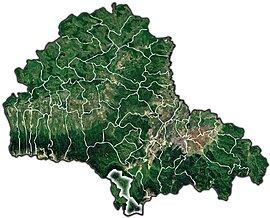
Moieciu
Moieciu | |
|---|---|
 | |
 Location in Brașov County | |
 Moieciu Location in Romania | |
| Coordinates: 45°30′28″N 25°20′33″E / 45.50778°N 25.34250°ECoordinates: 45°30′28″N 25°20′33″E / 45.50778°N 25.34250°E | |
| Country | Romania |
| County | Brașov |
| Government | |
| • Mayor (2020–2024) | Ioniță-Mircea Manea[1] (PNL) |
| Area | 94.91 km2 (36.64 sq mi) |
| Highest elevation | 1,200 m (3,900 ft) |
| Lowest elevation | 800 m (2,600 ft) |
| Population (2011)[2] | 4,892 |
| • Density | 52/km2 (130/sq mi) |
| Time zone | EET/EEST (UTC+2/+3) |
| Vehicle reg. | BV |
| Website | www |
Moieciu (German: Mösch; Hungarian: Alsómoécs) is a commune in Brașov County, Transylvania, Romania. It is located 29 km south of Brașov, within the Bran Pass.
The commune is composed of six villages: Cheia (Kheja), Drumul Carului, Măgura (Magura), Moieciu de Jos (the commune center), Moieciu de Sus (Felsőmoécs) and Peștera (Pestera). Măgura and Peștera are on the eastern side of the Piatra Craiului Mountains.

Măgura village

Moieciu de Sus scenery

Moieciu de Sus scenery

Moieciu de Sus scenery
References[]
- ^ "Results of the 2020 local elections". Central Electoral Bureau. Retrieved 9 June 2021.
- ^ "Populaţia stabilă pe judeţe, municipii, oraşe şi localităti componenete la RPL_2011" (in Romanian). National Institute of Statistics. Retrieved 4 February 2014.
External links[]
| Wikimedia Commons has media related to Moieciu, Brașov. |
- (in Romanian) Official site
- (in Romanian) Moeciu - Romania - Information about Moeciu resort
Categories:
- Communes in Brașov County
- Localities in Transylvania


