Momhil Sar
show This article may be expanded with text translated from the corresponding article in German. (June 2011) Click [show] for important translation instructions. |
| Momhil Sar | |
|---|---|
| Mumhail Sar مومہل سر | |
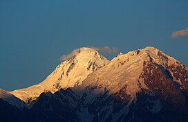 Momhil Sar in 2014 | |
| Highest point | |
| Elevation | 7,414[1] m (24,324 ft) Ranked 64th |
| Prominence | 980 m (3,220 ft) |
| Parent peak | Trivor |
| Listing | List of mountains in Pakistan |
| Coordinates | 36°19′10″N 75°02′06″E / 36.319351°N 75.035108°ECoordinates: 36°19′10″N 75°02′06″E / 36.319351°N 75.035108°E |
| Geography | |
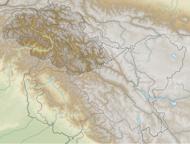
 Momhil Sar Location in Gilgit-Baltistan | |
| Location | Shimshal, Gojal, Gilgit-Baltistan, Pakistan |
| Parent range | Karakoram |
| Climbing | |
| First ascent | 1965[2] |

Momhil Sar (Urdu: مومہل سر), or Mumhail Sar as pronounced in Wakhi is at 7,414 metres (24,324 ft) above sea level, is the 64th highest mountain peak in the world.[1] Mumhail Sar in Wakhi means the mountain that overlooks or is above Grandmother's cattle pen or paddock. It is situated in Shimshal Valley the Hispar Muztagh subrange of the Karakoram range, a few kilometres to the north-west of its parent peak Trivor.
The first people to reach the top were Hans Schell and his expedition, in 1965.[2]
References[]
- ^ Jump up to: a b "Momhil Sar, Pakistan". Peakbagger.com. Retrieved 12 December 2019.
- ^ Jump up to: a b "Asia, Pakistan, Momhil Sar". American Alpine Journal. American Alpine Club. 1965. Retrieved 12 December 2019.
This Gilgit-Baltistan location article is a stub. You can help Wikipedia by . |
This Pakistan location article is a stub. You can help Wikipedia by . |
| Authority control |
|---|
Categories:
- Gilgit-Baltistan geography stubs
- Pakistan geography stubs
- Seven-thousanders of the Karakoram
- Mountains of Gilgit-Baltistan