Momina Klisura (Mesta)
| Momina Klisura | |
|---|---|
| Момина клисура | |
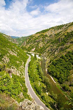 Mesta River at Momina Klisura | |
 Momina Klisura Location within Bulgaria | |
| Floor elevation | 642 m (2,106 ft) |
| Length | 25 kilometres (82,000 ft) north to south |
| Geology | |
| Type | Gorge |
| Geography | |
| Location | Pirin and Rhodope Mountains, Bulgaria |
| Coordinates | 41°43′29″N 23°41′31″E / 41.72472°N 23.69194°ECoordinates: 41°43′29″N 23°41′31″E / 41.72472°N 23.69194°E |

Momina Klisura (Bulgarian: Момина клисура, meaning Maiden's Gorge) is a steep valley along the river Mesta in south-western Bulgaria, stretching about 25 km.[1] Administratively, it is situated in the municipalities of Bansko and Gotse Delchev, Blagoevgrad Province. According to the legend, the gorge was named after a maiden, who fought the Ottoman Turks defending the fortress of and plunged into the abyss upon seeing that the stronghold was about to fall.[2]
Geography[]
Momina Klisura forms the divide between the Pirin Mountains in the west and the westernmost ridge of the Rhodope Mountains, Dabrash, in the east. It links the south-easternmost part of the Razlog Valley in the north and the northernmost part of the Gotse Delchev Valley in the south.[1] The gorge is about 25 km long with an average altitude of 642 m. It is narrow with steep slopes dug into metamorphic rocks, late Triassic sediment and vulcanite.[1] The river Retizhe, a right tributary of the Mesta, flows into its main course at Momina Klisura.[3]
The gorge takes its beginning east of the town of Dobrinishte, at the confluence with Bezbog River at an altitude of 693 m and heads to the south and south-east. The middle section is in the area of the village of Mesta, where the altitude is 642 m. Momina Klisura ends to the south-east of the village of Gospodintsi in the Gotse Delchev Valley at an altitude of 544 m.[2]
Along its length are located the villages of Filipovo, Mesta and Gospodintsi, as well as the ruins of the late antique and medieval fortress and another fortress near Gospodintsi.[1][2]
A 27.4 km long section of the second class road II-19 between Simitli, Bansko, Gotse Delchev and Ilinden at the border with Greece follows the gorge.[1][4]
Gallery[]

Momina Kula

Momina Kula


Citations[]
- ^ a b c d e Geographic Dictionary of Bulgaria 1980, p. 323
- ^ a b c Dushkov 1972, p. 114
- ^ Geographic Dictionary of Bulgaria 1980, p. 408
- ^ "A Map of the Republican Road Network of Bulgaria". Official Site of the Road Infrastructure Agency. Retrieved 5 July 2018.
References[]
- Мичев (Michev), Николай (Nikolay); Михайлов (Mihaylov), Цветко (Tsvetko); Вапцаров (Vaptsarov), Иван (Ivan); Кираджиев (Kiradzhiev), Светлин (Svetlin) (1980). Географски речник на България [Geographic Dictionary of Bulgaria] (in Bulgarian). София (Sofia): Наука и култура (Nauka i kultura).
- Душков (Dushkov), Добри (Dobri) (1972). Пирин. Туристически речник [Pirin. Tourist Dictionary] (in Bulgarian). София (Sofia): Наука и култура (Nauka i kultura).
- Canyons and gorges of Bulgaria
- Landforms of Blagoevgrad Province